B15A
Satellite image showing iceberg B-15
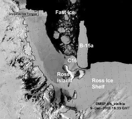
In March 2000, the iceberg B-15 calved from the eastern portion of the Ross Ice Shelf. The iceberg was 295 km in length and up to 40 km in width (~10 000 km2).
Almost immediately after calving, B-15 began to fragment. All but two icebergs drifted north. In November 2000 pieces of B-15 were still in the south-western Ross Sea, forming a barrier that greatly restricted the usual northwest drift pattern of pack ice. B15a and C16 (another piece of the Ross Ice Shelf knocked off by B15) remained in the vicinity of Ross Island for several years resulting in:
- Unusually heavy sea-ice concentrations throughout November and early December 2000
- Large amounts of sea-ice piled up on the south-east side of the icebergs resulting in less open water
- A decrease in primary productivity