Unsaturated zone modelling
Current model outputs of interest
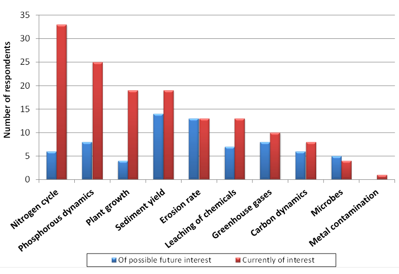
Current hydrological model outputs of interest are listed in Figure 3. There is great interest in modelling soil moisture, drainage, river discharge and groundwater recharge. Other model outputs that rely on hydrological input are listed in Figure 4. This highlights a demand for computing nitrogen fluxes, phosphate dynamics, plant growth and sediment yield. The modelling of nitrogen and phosphorous cycling and leaching requires a plant model. Nevertheless, the trend is to model nitrogen and phosphorous fluxes without using complex agricultural models such as by computing leaching risks by using simple index models imbedded into a GIS framework. Bypass flow, macroporosity and aeration are important processes in computing nitrate leaching. Nevertheless, Figure 3 shows that these processes are not widely taken into account in the models. This may be explained by the difficulties in obtaining these data.
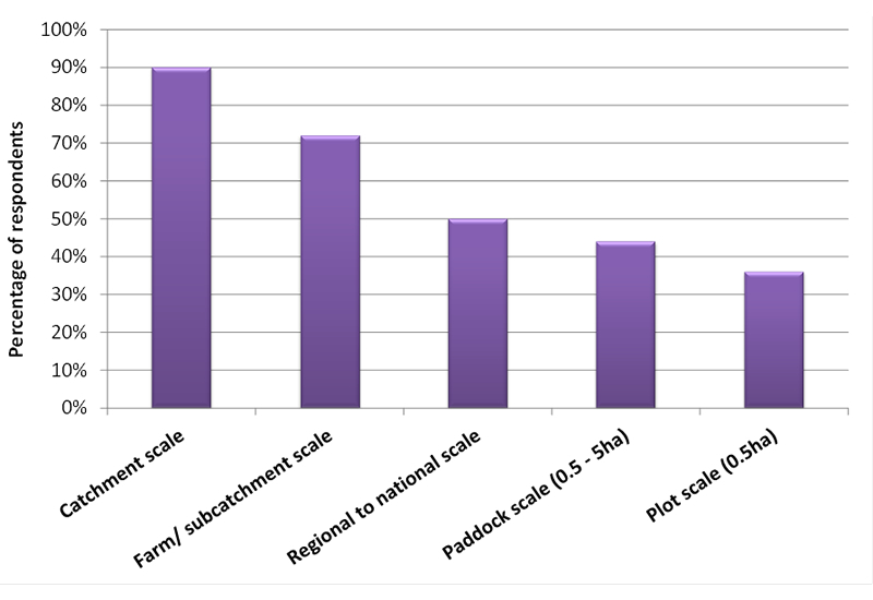
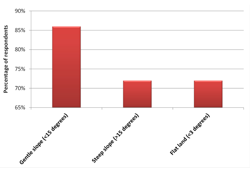
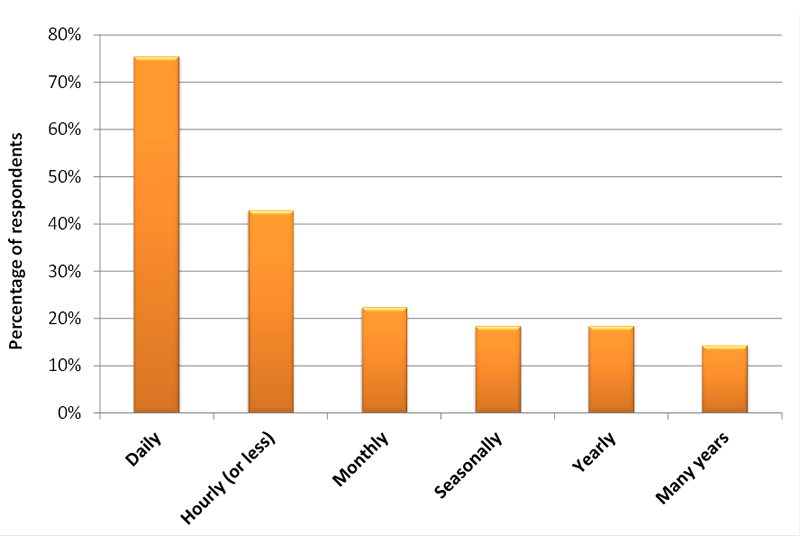
The survey shows that the main scale of interest is at the catchment scale (Figure 5), and on terrain <15° (Figure 6). These slopes include the intensively managed agricultural land. Participants with an interest in steep terrain are mainly focused on predicting river dynamics. The main time interval of interest is daily, (Figure 7), but there is also a requirement for hourly outputs, especially to model river dynamics.
Future model outputs of interest
The three main models of interest in this survey, ranging from the simplest to the most complex, are 1D models, 1D spatial models and 2D fully spatial models. 1D models are used to compute the vertical flow at a point, whereas 1D spatial models combine independent 1D models over an area of interest. The average hydrological outputs are then derived by performing spatial weighting average of a paddock or a catchment. The benefit of a 2D fully spatial model is that it can take into account lateral flow by modelling horizontal and vertical flow within the model itself, giving more realistic results in sloping terrain.
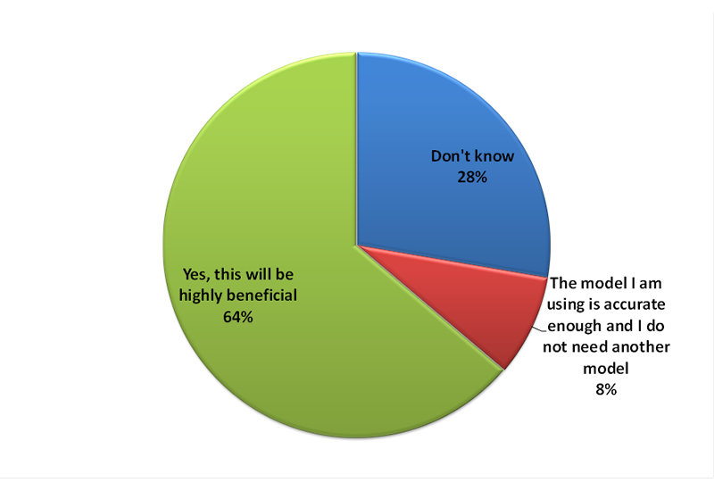
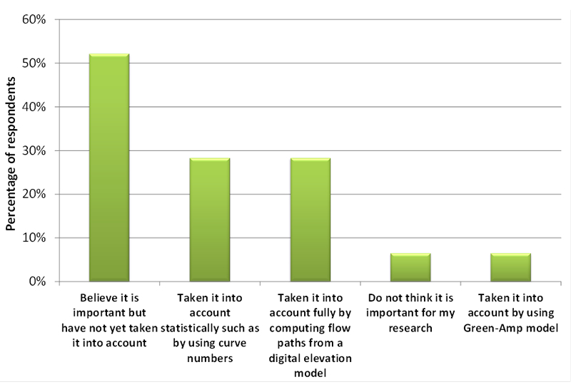
However, 1D models are easier to operate and therefore are more commonly used than spatial models (Figure 8). Nevertheless, most users (64%, Figure 9) believe that their modelled outputs (e.g. Nitrate transport) that rely on hydrological input could be significantly improved if they could plug-and-play their module of interest into hydrological output performed by 2D fully spatially hydrological model at the scale and time step of interest. Fifty-three percent of respondents believe that taking into account lateral flow would improve their model accuracies (Figure 10). Only 28% of the participants currently model lateral flow by using a 2D fully spatially model. The usage of a 2D fully spatially model instead of using a curve number (28%; Figure 10) would no doubt significantly improve the predictions of nitrate and phosphate leaching.
Figure 3 . Hydrological output of interest.
Figure 4 . Other modelled outputs of interest that require hydrological input.
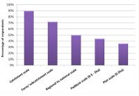
Figure 5 . Scale of interest (multiple choices accepted).
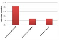
Figure 6 . Terrain of interest (multiple answers accepted).
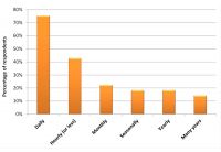
Figure 7 . Time interval of interest (multiple answers accepted).
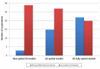
Figure 8 . Interest in 1D, spatial 1D and fully spatial 2D models.

Figure 9 . Interest in using the outputs of a time series hydrological model at the scale of interest.

Figure 10 . Participants’ ranking of importance of lateral flow (multiple choices accepted).