Impact of Himalayan thar on snow tussock grasslands in the Southern Alps
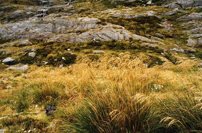
Vegetation plot in the Zora catchment (1999). In each measurement, the condition of at least 20 individual tagged tussocks is assessed, along with overall cover of all plant species present. Thar activity around each plot is assessed using faecal pellet counts. Image – DOC
Following their introduction into New Zealand in 1904, Himalayan thar (tahr) colonised over 8000 km2 and their population grew to over 50,000. However, during the 1970s, aerial commercial hunting reduced their numbers to less than 5000. In 1983, commercial hunting was temporarily banned allowing thar populations to partly recover.
Since 1993, thar have been managed under the Himalayan Thar Control Plan. This specifies intervention (control) densities above which thar impacts were thought to be ecologically unacceptable. These intervention densities are based on expert opinion, but the Plan also calls for further research and monitoring to enable periodic reviews of the appropriateness of the intervention densities.
In response to this recommendation, Landcare Research and the Department of Conservation (DOC) set up a programme in the early 1990s to determine ecologically acceptable thar densities from population assessments undertaken in parallel with vegetation monitoring. Eight catchments were selected where thar densities were well below, at, or far above specified intervention densities. Snow tussocks were chosen as the key indicator species as they constitute a large part of thar diet, but not of the diets of sympatric possum or chamois populations. Variably-sized permanent plots containing at least 20 adult snow tussocks were subjectively placed in areas used by thar.
Measurements for each individual tussock included basal live diameter (cm), maximum height of the extended live leaves (cm) and the amount of crown death estimated to the nearest 10%. The percentage of each plot covered with vegetation (of all plant species) was also measured to assess impact of thar on the overall vegetation present in the tussock grasslands. The level of thar activity was assessed near the plots using the proportion of 1-m2 plots containing faecal pellets (assumed to be mainly from thar since few other ungulates were present).
In the 20 years, the vegetation plots have been remeasured several times, and ungulate activity around the vegetation plots and thar numbers in the study catchments assessed. The monitoring was initially by Landcare Research, and later by DOC (see photo). Landcare Research was commissioned to review the data up to the latest measurements in 2004 and again in 2014.
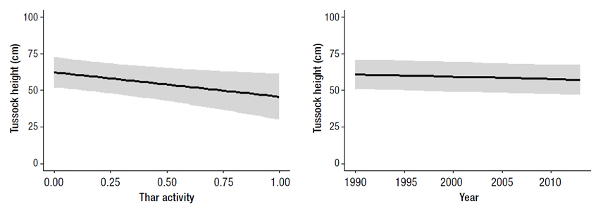
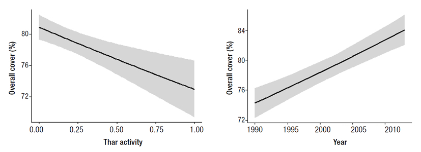
The 2004 review indicated that tussock condition was improving in catchments where thar were held below intervention densities but not in those where thar exceeded the thresholds. Unfortunately, the methodology used for assessing thar densities was not consistent, and in some years it was only possible to derive the minimum number of thar known to be alive. Reliable comparisons of thar density over time and across sites were thus impossible. Furthermore, relating plot data to catchment-wide thar counts involved introducing pseudo-replication into the design. Therefore, the 2014 review focused on comparing snow tussock condition and overall vegetation cover with thar activity immediately around the vegetation plots. This review used a mixed-effects linear model with tussock condition (i.e. height) as the response variable, and thar activity, elevation and aspect of the plot, year of sampling, live diameter and percentage of crown death of adult tussocks as explanatory (fixed) variables. To evaluate the effects on overall vegetation cover, a generalised linear model with Poisson error was used to account for the skewed distribution of vegetation cover. This second model included plot elevation and aspect, year of sampling and thar activity as explanatory variables. The main results suggest that (1) tussock condition decreased over time and continues to be negatively affected by thar (Fig. 1), and (2) although vegetation cover increased over time, it was also negatively impacted by thar at sites with high thar use (Fig. 2).
The latest review by Landcare Research identified a key shortcoming in the monitoring, namely inconsistency in the methods used to collect data relating to thar densities. Because of this, it is impossible to address the key question behind the original study, i.e. what are ecologically acceptable thar densities? This observation highlights an issue for long-term studies in general, in that the initial intent, management and data requirements of such studies risk being relaxed or forgotten over time, thus greatly reducing their value.
Nonetheless, results from the latest review demonstrate that current levels of thar control are not sufficient to maintain the status of tussock grasslands, let alone enable their recovery. This is not surprising, as the intervention densities specified in the Thar Control Plan were exceeded at all eight study sites monitored (based on minimum numbers of thar known to be alive). Thar management is now being reviewed to achieve better conservation outcomes in the future.
This work was jointly funded by the Department of Conservation and Landcare Research.
Ingrid Gruner (DOC) igruner@doc.govt.nz
Jennyffer Cruz, Caroline Thomson, John Parkes (Landcare Research)
David Forsyth (Arthur Rylah Institute)
Fig. 1 Predicted mean relationships between tussock height and thar activity (left), and between tussock height and year of monitoring. Shaded areas are the 95% confidence intervals.
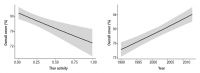
Fig. 2 Predicted mean relationships between overall vegetation cover and thar activity, and between vegetation cover and year of monitoring. Shaded areas are the 95% confidence intervals.