Issue 5, June 2011
News about Landcare Research science relevant to the Ministry of Agriculture and Forestry.
In this issue:
|
|
Editorial
Welcome to the latest edition of our regular e-newsletter aimed at keeping MAF staff up to date with relevent research being undertaken by Landcare Research.
How often do we hear the slogan “the answer lies in the soil”? At Landcare Research we certainly believe that managing our soil health is a key component of pasture productivity. Here, we report on two very different research initiatives around management of soil health.
The introduction of dung beetles may see the much faster breakdown of dung patches in pasture. And, to avoid the loss of soil a significant effort is being made to improve erosion models that predict the impact of farm management changes on sediments entering rivers.
We have seen how carbon foot printing of products and industries is relatively common place in the world now but water foot printing appears to be the next ‘cab off the rank’ and here we report on some studies involving kiwifruit.
With the tenure review process for South Island high country farms well under way what will happen to the retired land? We think there might be profound effects on long-term successional trajectories of grassland/shrubland ecosystems. We also believe the monitoring and management of changing forest and shrubland in New Zealand will benefit from a comprehensive new classification system that we have recently developed.
And finally for those interested in weed and pest management we report on three very different initiatives. The first biocontrol agent for woolly nightshade (Solanum mauritianum) has now been released in New Zealand. And we have some of our latest research on the role pigs play in maintaining Tb in wildlife and understanding possum ecology.
We hope you enjoy the content of this e-newsletter.
Best Regards,
Phil Hart
Land & Water
Dung Beetles
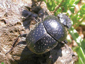 Farmers could soon have an unlikely ally in their efforts to improve environmental stewardship as Landcare Research is breeding colonies of exotic dung beetles for release. Improved soil health, reduced nitrous oxide emissions and improved pasture productivity are just some of the potential benefits provided by the beetles.
In February the Environmental Risk Management Authority (ERMA) approved the Dung Beetle Release Strategy Group’s application for the importation and release of 11 species of dung beetles in New Zealand. Staff at Landcare Research, which has been providing the science support for the group, travelled to Australia to collect specimens of three types of dung beetles that are now being bred in containment at Lincoln.
The beetles are being studied to ensure they are disease-free before MAF will give permission for their release. Landcare Research is also planning to import breeding stocks of further species from Australia, and others from South Africa and France.
Dung beetles search out the faeces of animals which they use for food and reproduction. Most adult dung beetles make tunnels in the soil beneath the faeces which they then bury to lay eggs in. Other species make balls from the faeces which they roll away and bury deep beneath the soil surface before adding an egg.
As the eggs hatch the grubs feed on the dung so they break it down and eventually turn it into a sawdust-like material that actually adds to the fertility of the soil structure while all the time getting rid of dung sitting on top of the ground.
Researchers Shaun Forgie and Hugh Gourlay say that while dung decomposes naturally, intensive farming means large amounts of dung are dropped which can lead to environmental problems such as leaching of nutrients into waterways and reduced pasture production because of increased forage fouling.
‘If we successfully introduce and establish exotic dung beetles in New Zealand we expect that in the long term there will be millions chewing and burying dung from pastoral animals such as cows and sheep and that means a monumental management change for our farmers,’ Mr Gourlay says.
That is because dung beetles have many potential environmental and economic benefits, says Dr Forgie:
- Improved soil health and reduced runoff. Increased aeration and water penetration into the soil, through beetle tunnels, reduces urine and liquid dung runoff, reducing microbial contamination, leachate pollution, and eutrophication of waterways;
- Likely contribution to reduced nitrous oxide emissions. Herbivore excreta account for 20% of New Zealand’s N2O emissions and 80% of the nitrogen content of dung is lost by volatilisation when dung remains on the pasture surface, compared to only 10% following burial by dung beetles;
- Greater pasture productivity. Stock will not graze around dung pats, reducing pasture productivity and burial of nutritious manure by dung beetles enhances grass growth, reducing reliance on fertiliser inputs. Solid fertiliser is one of the biggest working expenses on most conventional livestock farms;
- Reduced fly pests and human disease. Nuisance flies breed in dung but are outcompeted for resources by fast dung burying beetles. In Hawai’I, introduced dung beetles reduced dung breeding pest flies by as much as 95%;
- There will also be reduced infection by parasitic worms of livestock because dung burial removes the infective stages of parasitic worms of livestock. This would reduce the need and expense of drenching stock.
In the United States, which has 100 million cattle (New Zealand has ten million cattle) the services provided by dung beetles in removing cattle dung have been estimated to be worth US$380 million/yr to the US economy.
New Zealand lacks native pastoral dung-burying beetles. A tropical species Copris insertus was introduced in 1956 at Whangarei, and presumably due to poor climate matching, now has limited distribution North of Auckland. Two accidentally introduced Australian Onthophagus species are widespread, but have little impact, because they are small beetles that bury less dung, and don’t achieve sufficiently high densities in livestock dung.
Further information:
Shaun Forgie
Soil conservation reduces sediment yield in rivers
Many rivers in the Manawatu-Wanganui region are silt-laden because of hill-country erosion. Sediment is deposited on river channels, reducing flood capacity and spoiling aquatic habitat. Sediment is also a major source and carrier of phosphorus that degrades water quality. The Horizons Regional Council are encouraging soil conservation through the Sustainable Land Use Inititiative (SLUI). Farm plans are being developed for farms on highly erodible land and farmers are subsidised for erosion control works, such as forestry, retirements, and soil-conservation tree planting. SLUI will spend up to $80 million in the Manawatu-Wanganui region.
To help plan and assess progress in SLUI, John Dymond (Palmerston North), Daniel Rutledge (Hamilton) and Suzie Greenhalgh (Auckland) of the Ecosystem Services Program for Multiple Outcomes are providing a model for assessing the impacts of farm plans on sediment yield. The model integrates the soil-conservation effects of farm plans over water management zones throughout the region. Sediment yields are estimated for present day, for 2020, and for target (i.e. all farm plans implemented and fully mature). Results showed that many of the silt-laden rivers have a target reduction of about 50% in sediment yield, such as the Turakina, Middle Whanganui, Lower and Middle Whangaehu, Akitio, and Owhanga. By 2020, about half of the target reduction would have been realised.
The water management zones of the Manawatu River generally have lower targets of about 25% reduction, with the exception of the Tiraumea tributary that has a target of about 50%. These data are being used by the Integrated Freshwater Solutions program (MSI funded) in their mediation of stakeholders in the Manawatu river accord. In future, the model will be further improved using more comprehensive measurements of erosion and sediment transport in the Clean Water Productive Land research program (MSI funded).
Further information:
John Dymond
Development of a new erosion model for New Zealand: SedNetNZ
 To be useful to land managers erosion models need to be able to provide information on spatial patterns of sediment sources, contributing processes (e.g. landslides, gully, bank erosion), and land use influences on erosion. This would allow better targeting of erosion mitigation measures and assessment of their success on-site and off-site. Both empirical (e.g. NZeem®, SPARROW) and dynamic simulation models (e.g. WEPP, SWAT, SHETRAN) have recently been used in New Zealand. Empirical models have limitations such as lack of process representation, while dynamic models are very difficult to parameterise and apply at large spatial scales and typically don’t simulate mass movement erosion.
As part of the Ministry of Science and Innovation-funded programme ‘Clean water, productive land’, Landcare Research is developing a new erosion model based on the Australian sediment budget for river networks model (SedNet). This approach provides a middle ground between lumped empirical models and dynamic simulation models. The impetus for this development is to provide a model with better erosion process representation, explicit linkage between hillslopes and channels, and simulation of catchment-scale connectivity in order to be better able to simulate the effects of land management changes on upstream sediment loading and downstream response.
The basic element in the model will be the stream link. Each link has an internal catchment area (watershed) which drains overland flow and delivers sediment to that link. For each link an annual mass budget and sediment yield is calculated by taking the difference between: (1) the sum of sediment supplied from the internal catchment area and upstream tributaries; and (2) the loss of sediment in the channel, on floodplains and in any reservoirs and lakes. Sediment supply is the sum of sediment delivered from hillslope (landslide, earthflow, surface wash), gully and riverbank erosion processes. The main outputs from the model will be predictions of mean annual bed and suspended sediment loads in each stream link, throughout the river network. Because source erosion will be spatially linked to sediment loads, it will be possible to examine the proportionate contribution that specific areas of land make to downstream export of sediment. By adjusting input data and model parameters it will be possible to simulate river loads for natural conditions (pre-European) and examine the consequences of future land use or climate change scenarios.
The model is being developed using the Manawatu River as a case study and utilising the extensive set of suspended sediment data currently being collected by Horizons Regional Council. The Manawatu also provides the opportunity to demonstrate the effect of land management change, being implemented as part of SLUI, on sediment generation and transport. Ultimately we aim to incorporate SedNetNZ into the CLUES modelling framework to replace the current sediment model (SPARROW).
Further information:
Chris Phillips
Les Basher
Water footprinting the kiwifruit supply chain
 Freshwater consumption in the growth of food products is fast emerging as a major issue for global retailers and businesses, such as Unilever, in a similar fashion to carbon footprinting. Water footprints are intended to improve consumer understanding of freshwater consumption by products and potentially heighten awareness of options for reducing freshwater consumption within global supply chains. For example, agricultural activity is estimated to constitute on average 80% of the water footprint of food products. It is becoming abundantly clear that, unless businesses begin to address issues such as reducing competition for scarce water resources, they will face major challenges in securing enough water to underpin economic growth and meet environmental requirements.
MAF and Zespri International commissioned Anthony Hume and Carla Coelho (both Wellington) to assess the water footprint of green kiwifruit supplied to the UK — the environmental impact of water used, directly and indirectly, throughout all stages from growing the fruit through to it reaching the consumer. The recently completed project, a partnership with Plant & Food Research and AgriLink, was the first-ever comprehensive water footprinting exercise to be carried out in the New Zealand horticulture sector.
Anthony and Carla evaluated two emerging approaches - the Water Footprinting Network (WFN) and Life Cycle Assessment LCA), and also investigated a third hydrological-based perspective. Used in tandem, these different approaches provide deeper insight into the direct and indirect freshwater consumption by a product. Applying the volumetric WFN methodology on the orchard showed that, based on the national average, the majority of water consumed in the cultivation of green kiwifruit (85%) is taken from rainwater or soil moisture. Five percent of water consumed was taken from irrigation and 10% is the volume of water needed to dilute orchard inputs below safe drinking standards e.g. nitrogen fertiliser entering the environment. At the orchard gate green kiwifruit has an average water footprint of 417 litres per kg of fruit.
The LCA work highlighted regional differences in potential environmental impacts from the freshwater used in cultivation - several regions made a relatively low contribution to national production yet had relatively high environmental impacts. For example, the contribution of the Auckland region to environmental impacts of freshwater consumption is given greater importance using the LCA environmental impact indicators than the WFN method. One possible explanation could be that areas with a high population density tend to place higher stress on water resources because of higher urban use rates and can fare worse than other areas; the LCA method takes into account basic socio-economic factors that lead to domestic, industrial and agricultural water use.
The hydrological perspective included run-off and drainage flows not taken into account in either the WFN and LCA footprint methods but usually included in water balance assessment, and was developed as part of research looking at reducing water use. The first scenario was to convert all irrigated kiwifruit orchards in all regions to rain-fed orchards. At the regional scale, converting irrigated orchards into rain-fed orchards had a significant impact on water footprints for only the low rainfall areas (Hawke’s Bay, Gisborne and Nelson). However, this significantly reduced orchard gate returns for Hawke’s Bay and Nelson. In principle, this is a feasible option only for Gisborne. Several other options associated with the use of N fertilizer in the Te Puke region were examined. Neither the application of fast-release nitrogen fertiliser nor halving of the amount of nitrogen fertiliser typically applied had a significant influence on the water footprint.
Water footprinting methods are developing very quickly as more company and sector case studies are published. Although the project highlighted a number of important data gaps requiring further investigation throughout the supply chain, the research has been of considerable value to Zespri. They will use results to support positive positioning with key global retailers, such as Walmart, Marks & Spencer and Sainsburys, that are increasingly paying attention to water footprints of suppliers.
Other water footprinting projects are underway currently for the red meat and merino sectors, with several different methods being developed in parallel. MAF will use the results to understand the differences between the different methods advocated, and to formulate New Zealand’s responses to the development of the ISO water footprinting standard. The case studies will be used to bolster awareness of global interest in the water footprint of New Zealand’s agricultural products. Domestically there could be potential opportunities to use water footprinting data in water allocation discussions, for example to identify rain-fed orchards that do not rely on an allocation of irrigation water.
Further information:
Anthony Hume
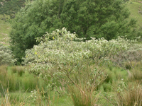
Removal of grazing increases species richness in dryland ecosystems
 A medium-term goal of our researchers in the Dryland Strand is to determine the influence of invasive species on vegetation succession. Several non-forest ecosystems in the eastern South Island are perfect ‘outdoor laboratories’ for understanding shrub succession because they are currently being retired from pastoral use through Tenure Review. This amounts to thousands of hectares of grassland/shrubland ecosystems that are often under-represented in legal protection. Yet former pastoral lease lands potentially have high conservation values and require management that takes into account future transition to shrub dominance.
Andrea Byrom, Richard Clayton, Roger Pech and Amy Whitehead investigated the effects of livestock exclusion on native vegetation in dryland communities by comparing sites where grazing ceased 10–30 years ago with paired sites where grazing has continued. Ungrazed sites had significantly higher native vegetation richness and lower exotic richness than grazed sites. Ungrazed sites also had significantly more native shrubs than grazed sites and higher shrub cover. These differences were reflected in the invasive mammal community: grazed sites were typically associated with higher abundances of rabbits and hedgehogs whereas hares, possums and mice were dominant in ungrazed sites. The team have concluded that removal of livestock grazing can have profound effects on long-term successional trajectories of grassland/shrubland ecosystems, and on the potential impacts of invasive mammal pests. By quantifying ecological community responses to retirement of land to the conservation estate we can support evidence-based management of such ecosystems. The next steps will be to examine the role that invasive mammals play in the invasion and spread of non-native woody weeds.
Further information:
Andrea Byrom
Native Forest Management
New forest and shrubland classification system
The monitoring and management of changing forest and shrubland in New Zealand will benefit from a comprehensive new classification system.
More than 70% of New Zealand’s forest and shrubland has been lost in the 800 years since human arrival through fire, land clearance and logging.
“Remaining forest and shrubland continues to be impacted, for example by invasive species and land-use change, so an up-to-date depiction of the composition, extent and structure of these woody communities, at a range of scales, is valuable,” says Project Leader, Dr Susan Wiser.
Landcare Research has used the LUCAS (New Zealand Land Use and Carbon Analysis System) plot network, established from 2002 to 2007 primarily to monitor carbon stocks, to reclassify our forest and shrubland cover.
Using the 1177 nationally representative vegetation plots (positioned on an 8km x 8km grid across the country), the researchers were able to identify 24 different broad vegetation classes termed ‘alliances’.
Each alliance was evident at between 19 and 105 plots, with each comprising an estimated land area of 144,000–794,000 ha.
“Stand structure data suggest that 16 of these alliances are largely stable whereas eight will undergo compositional change, so the new classification system will be valuable in managing that change,” says Susan.
“Previous classifications and vegetations maps, although based on the best information and analytical techniques available at the time, were either out-of-date, too broad, or didn’t accurately depict the actual vegetation.
“For example, in some areas the maps were largely dependent on aerial imagery, so they focused on canopy composition, or could not accurately distinguish between species such as the different beech (Nothafagus) varieties. From an applied perspective, this is important as Nothofagus now is the main indigenous New Zealand species managed for timber production in New Zealand. Landowners developing sustainable management plans, as required by law, need a framework to describe the specific type of Nothofagus forest they plan to manage, in a consistent way that can be readily placed in a national context.”
So what are the most obvious differences between the latest and previous classifications?
“Our new classification provides more differentiation of types in our most widely distributed forests and highlights the extent of alliances in disturbed landscapes, as well as those that are compositionally dynamic, and those invaded by exotic species. These are areas with high potential for future carbon sequestration and biodiversity enhancement, but still remain poorly understood.”
Work on the classification was funded by DOC, MAF’s Sustainable Farming Fund and Landcare Research internal funding.
Further information:
Susan Wiser
Weed & Pest Management
Intra-specific transmission of Tb among penned pigs
The following research by Graham Nugent, Ivor Yockney and Jackie Whitford appeared in the Journal of Wildlife Diseases earlier this year.
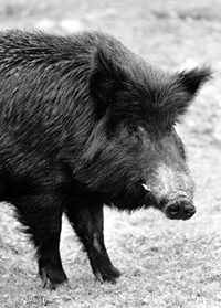 In New Zealand, pigs are known hosts of Bovine Tuberculosis (Tb), but there was some uncertainty as to the role pigs play in maintaining Tb in wildlife. This is of interest because it informs management questions such as “Is pig only, possum only, or a combination of control required for rapid elimination of Tb?”
Between 2002 and 2006, we studied the transmission of Tb between pigs. In two 1-ha pens in natural habitat uninfected ‘sentinel’ pigs were kept with wild-caught feral pigs, most of which were infected with M. bovis. The pens kept the pigs from contacting other wildlife sources of Tb such as possums. Other sentinel pigs were radio collared and released to the wild outside the pens where they could encounter Tb sources including possums and other pigs. The rate of Tb transmission to sentinels was used to assess whether intra-species transmission between live pigs could explain the high levels of infection in the wild population.
In Trial 1, no new infection was detected in 18 penned sentinels after combined exposure of 3.9 years, whereas three of 11 sentinels in the wild became infected. In Trial 2, more heavily infected Tb-source pigs were used (94% prevalence cf 42% in the first trial), and one (4%) of 25 penned sentinels became infected over a combined exposure time equivalent to 3.1 years. At the same time, more (75%) of the eight sentinels released to the wild became infected.
Calculating an apparent annual incidence and comparing between treatments (pen v wild), the difference was significant: 0.03± 0.12 (95%CL) for penned sentinels, 1.06± 6.74 for released sentinels; t = -3.51, p = 0.04. Based on these results, and taking pig longevity into account, it does not appear possible for pig-pig transmission alone to explain the high Tb prevalence found in the wild pig population at our study site. Whilst care must be taken in extrapolating these results, the high prevalences seen in some New Zealand feral pig populations are therefore likely to result from transmission from some other host (most likely possums) and by some other route (most likely scavenging by pigs).
Further information:
Graham Nugent
First biocontrol for woolly nightshade
 The first biocontrol agent for woolly nightshade (Solanum mauritianum) has now been released in New Zealand.
The woolly nightshade lace bug (Gargaphia decoris) was released in a forestry block in Tauranga by Environment Bay of Plenty who had madde the first application to ERMA to release the lace bugs.
Since then releases have been made in Waikato, Taranaki, Northland, Manawatu-Wanganui, and at other sites in the Bay of Plenty. More widespread releases are planned.
We are looking forward to the lace bugs settling in and feeding on woolly nightshade. Having seen the potential for serious damage they have demonstrated in South Africa (the only other place where they have been released for biocontrol) and knowing that there will be less pressure from predators here, we are expecting positive results.The next step in the biocontrol programme will be to work towards releasing a second agent, which is likely to be a tiny weevil (Anthonomus santacruzi), which feeds on the flower buds.
Woolly nightshade is a major pest in the Waikato region because it invades open areas such as pastoral land, native forest margins and urban areas.
It grows quickly and produces large amounts of seed. For example, a single plant can produce up to 10,000 seeds. The seeds are spread by birds, and can remain alive ‘viable’ in the soil for 20 to 30 years before germinating.
Woolly nightshade can quickly establish large groups (or stands) of plants. It takes over an area by ‘crowding out’ other plants and stopping them from growing.
If you come across woolly nightshade:
- Don’t eat the berries - they are moderately toxic to people, especially children.
- Don’t touch the leaves - they shed fine hairs when touched, which irritate the skin, eyes, nose and throat.
- Keep stock away - berries may also be toxic to livestock.
Further information:
Chris Winks
Possum ecology in dryland ecosystems
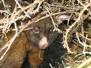 Members of the IMI team recently submitted a paper to the New Zealand Journal of Ecology describing the ecology of brushtail possums in a dryland environment on Molesworth Station in the north-east of the South Island. Although possums are a major environmental and agricultural pest in New Zealand, there is little information available on their ecology in drylands, which cover around 19% of the country. Al Glen and colleagues described a snapshot of possums’ diet, feeding preferences, movement patterns and survival rates. This basic ecological information will be useful in modelling and managing the impacts of possum populations in drylands. The summer diet, based on the stomach contents of 100 possums, was dominated by forbs and sweet briar, both of which were consumed in larger amounts than expected based on their availability. Possums also strongly preferred crack willow, which was uncommon in the study area and consumed only occasionally, but in large amounts. Radio-tracking suggested that possums on Molesworth may have unusually large home ranges. Whereas possums in New Zealand forests typically occupy home ranges of 1–2 ha, possums on Molesworth occupied areas averaging 5.1 ha. During the daytime, possums most commonly sheltered in sweet briar shrubs and rock outcrops. The results suggest that invasive willow and sweet briar may facilitate the existence of possums by providing abundant food and shelter. In turn, possums may facilitate the spread of weeds by acting as a seed vector. This work is being followed up with a more intensive study of possum movements and home ranges in dryland environments by Ivor Yockney, Graham Nugent, Carlos Rouco and Grant Norbury.
Further information:
Al Glen
Points of Interest
Magnetic South
This week (June 14/15) we are initiating an online idea-generating game designed to help people explore the future together.
It’s clear that some of the decisions we all make will shape Christchurch well beyond today. But how do we know what will be needed in twenty or thirty years from now?
It is an exercise that could be of interest to MAF staff.
Whether you have five hours or five minutes, you can help explore what the future will be like, and what this will mean for the decisions we make for Christchurch. Participants can draw on the collected knowledge and creativity of everyone playing to spotlight unexpected challenges, and help reveal new solutions to keep Christchurch vibrant and thriving in the next few decades.
To learn more and to register please go to the website: http://magneticsouth.net.nz/
Landcare Research website survey
We’re asking for assistance from key stakeholders to improve our public website.
The online survey will take you just 5 minutes and is aimed at finding out what you think we could do to improve our online presence.
Here’s the link: https://www.surveymonkey.com/s/LCRWebsite
Please note: The newsletters are to keep MAF informed about current research projects. The news items may include interim results that have not been peer reviewed. They should not be disseminated or quoted without first contacting the person mentioned at the end of each item.