Issue 6, September 2011
News about Landcare Research science relevant to the Ministry of Agriculture and Forestry.
In this issue:
Editorial
Kia ora tatou,
I’m delighted that the first of our ‘Landcare Research link’ lunchtime seminars for policymakers will be held in your Pastoral House, Wellington office tomorrow (Tuesday 27 September).
This first session on ‘Estimating the Impacts of a Multi-Policy Initiative at the Catchment Level’, focuses on the Hurunui Catchment. If you’re based in the capital, I hope you can get along to this discussion, which we envisage will be the first in a series.
In this edition, we cover some exciting new developments relevant to MAF. The next two versions of the Land Cover Database (LCDB), which some of you are involved with, will provide insights into the way land cover and land use is changing in this country.
Improving access to information is a key focus for us at Landcare Research. We’re using the latest online database and visualisation technologies to present information in intuitive and engaging ways. In this edition, we outline how more of our extensive soil information is becoming more accessible through the new S-Map Online website, and the upgrade of the SINDI (Soil INDIcators) website.
There is a lot more soil-related news in our September edition of ‘Soil Horizons’ newsletter and the latest edition of our ‘What’s New in Biological Control of Weeds?’ newsletter is hot off the press as well.
As always, I welcome your feedback.
Best Regards,
Phil Hart
Land & Water
New databases to highlight land cover change
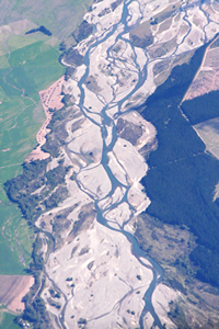
 How and where is land cover in New Zealand changing through time? What are the major characteristics of this change? These two key questions that will be answered by new editions of the New Zealand Land Cover Database (LCDB).
LCDB is a digital map of the surface of New Zealand created using satellite imagery. It contains detailed information on categories of land cover and boundaries, and is a record of land cover changes over time.
Two completed editions (LCDB1 and LCDB2), which show the state of New Zealand’s land cover in 1996-1997 and 2000-2001 respectively, have become critical to central, regional and local government, industry and research institutions. The information is used for land, water and biodiversity management, pest control and monitoring, wildfire threat and risk analysis, and environmental monitoring and reporting.
The creation of new land cover databases and related research has been identified as an important priority by Ministry for the Environment (MfE), Department of Conservation (DOC) and regional councils.
Landcare Research has been commissioned to deliver two further editions of LCDB and, a parallel research programme that will develop improved ways of generating land cover information.
The two new editions will leverage off the significant investment by MfE in research and imagery for their Land Use & Carbon Analysis System (LUCAS) programme. LCDB3 will be derived from the 2008 LUCAS satellite imagery and delivered in July 2012, while LCDB4 will use 2012 LUCAS imagery and will be delivered in July 2014.
“This project will answer key environmental research questions about how land cover is changing,” says Project Leader, Peter Newsome. “The research will also answer a number of other fundamental research questions about land cover classification.
“This research has spin-off benefits for other applications that require spatial analysis and classification of imagery – ranging from the monitoring of sustainable land use, habitat analysis, agricultural applications, economic modelling, to disaster response planning.
“Our goal is that by 2015 end-users will have access to a well established series of LCDB editions that provide the authoritative record of land cover and land cover change in New Zealand. These datasets will be widely used to support decisions on land utilisation, along with monitoring and reporting requirements.
“Landcare Research will also have an effective methodology and the experience and user support to take the series into the future as a leading edge land cover classification utilising the most appropriate satellite imagery available at the time.”
Peter says the project is collaborative, involving MfE, DoC, MAF and regional councils. “They will actively participate, contributing data and participating in specific activities, such as field verification.”
Governance and wider stakeholder advisory groups will be formed to guide future development of the LCDB and the research priorities required to deliver it.
The development of LCDB3 and LCDB4 is largely being funded by MSI and MfE, with support from DOC, MAF and regional councils.
Further information:
Peter Newsome
New tool for classifying land use and monitoring land-use change
 A new tool to help characterise, classify and monitor land use and land-use change across New Zealand is being developed by Landcare Research and the Regional Council Land Monitoring Forum.
Tentatively named the ‘Land Use Classification and Analysis Support System’ or LU-CLASS for short, the tool will enable users to combine a range of input data to produce customised maps depicting land use.
“A user will be able to enter spatially referenced data, such as processed aerial imagery or consent information, to produce classification information that meets their needs,” says Project Leader, Dr Daniel Rutledge.
“The power of the tool is that someone else, perhaps in a different organisation, can take the same input data, a subset of it or even different information, and recreate the same classification, a modified one to meet their information needs, or even generate an entirely new classification.”
Daniel says the aim is to promote consistent and reliable information. “We want the generation of land-use information to be repeatable and transparent, so we can monitor land-use change, and transferable across scales and across organisations.”
The LU-CLASS project has also produced a draft national land-use classification designed by regional council to meet their needs.
Funded by Envirolink, LU-CLASS will be publically available in December. Initially the tool will require an ArcGIS Version 10 licence to run. “Eventually we hope to make LU-CLASS web-based and accessible to anyone wanting to create and explore their own land-use information.”
LU-CLASS consists of several components:
- A database containing the information needed to process input data to produce the resulting land use classification;
- Two executable programmes: one for atomising the input data and a second for classifying it;
- A parameter file to store information needed to re-run the classification process.
LU-CLASS works by taking input data and dividing it into individual data ‘atoms’ according to user specified rules. Each data atom holds a single piece of information depicted at the spatial and temporal resolution desired by the user, subject to the resolution of the original data.
LU-CLASS then processes and combines the individual data atoms according to additional user-specified rules to produce land-use maps (technically geospatial data layers) that satisfy the desired classification specifications.
Further information:
Daniel Rutledge
Online access to soil information
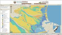 Landcare Research has unveiled a new online tool that helps people to better understand the soils that underpin New Zealand’s economy, land use and ecology.
S-map Online (http://smap.landcareresearch.co.nz) is a web browser service which provides easy access to information on the soils likely to be found at a location of interest.
It’s based on ‘Google Earth’ style navigation to make it easy to search, view and query, and allows a user to:
- explore interactive maps of soil properties such as soil drainage and available water;
- learn about the soil in their backyard or paddock;
- view detailed information about soil classes or attributes;
- create custom PDF soil maps for printing;
- for specific locations, download soil factsheets which provide more detailed knowledge of soil properties and information relevant to a variety of potential uses.
S-map Online is based on a digital soil spatial information system that is being populated with data to provide consistent and comprehensive national soil data layers to support applications at local, and regional to national scales. It improves on previous soil mapping, fills gaps with new mapping, and upgrades the associated soil property information to meet a new national standard.
Landcare Research’s Informatics Team Manager David Medyckyj-Scott says the launch of S-map Online is a “further step towards meeting the Government’s Declaration on Open and Transparent Government, and the requirement that data and information should be open and readily available”.
“A year ago today Landcare Research launched the LRIS portal, which gave those working in regional and central government, in industry, in research and in education access to environment data held by Landcare Research. Aimed at the professional data user, uptake of the service has been high and it is proving to be a great success. However, we felt there was a need for services which make data available in a much more user friendly and informative way and without the need to work with the data directly. So we are delighted to now be able to announce this new soils information service. ”
As well as access to detail soils information, the S-map Online web service has excellent, high quality base maps including maps based on LINZ topographic data. These allow the user to not only locate an area of interest with a high degree of accuracy but also provide a geographic context for the soils data.
Although S-map coverage is not yet complete, there is sufficient coverage to make the service a useful resource for many people. Work continues to extend S-map to the Environment Waikato and Environment Canterbury territorial areas, the soft-rock hill country in the central North Island and parts of Northland, Gisborne, Hawkes Bay, Manawatu, Wairarapa, Golden Bay and the West Coast.
“We also have plans to further develop S-map Online so users can develop their soil knowledge and ultimately make better informed and more reliable land use decisions and we’ll keep users informed of these developments,” says David.
During the initial period of operation, access to S-map Online outside of office hours is not guaranteed.
Further information:
About the service: David Medyckyj-Scott
About S-map: Allan Hewitt
Updated website to assess soil quality
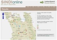 Landcare Research has updated its SINDI (Soil INDIcators) website (http://sindi.landcareresearch.co.nz) to help landowners and other decision makers assess and learn about soil quality.
Originally launched in 2000, SINDI helps people interpret a set of dynamic soil quality characteristics relating to the organic resources, fertility, acidity, and physical quality of a soil.
“The results help inform people about the general quality of their soil and suggest suitable management practices to remedy soil degradation,” says Landcare Research soil scientist, Dr Bryan Stevenson.
“We have now updated the site to make it more user friendly and interactive. People can compare their soil with information from our soils database, and see how their soil measures up against current understanding of optimal values. They can also learn about the effect each indicator has on soil quality and some general management practices that could be implemented to improve the soil.”
The updated site also has a link to the new S-map Online website. This means landowners can obtain additional soils information (soil maps and soil factsheets) for their area.
“In addition to updated information for landowners, regional councils can now use SINDI to generate soil quality statistics on a regional scale and display the data through a map interface. This will be useful for councils’ State of the Environment reporting.”
Underpinning the website is data from the approximately 1000 sampling sites across New Zealand. “Many of these sites have been resampled several times and the dataset from these resamplings represents a valuable resource to assess how our soils change over time,” says Bryan.
The update of the SINDI website was made possible through the New Zealand EnviroLink fund administered by the Ministry of Science and Innovation (MSI).
Further information:
Bryan Stevenson
New model for assessing the economic and environmental impacts of decision making
 Landcare Research has developed a new model to help decision-makers assess the potential economic and environmental impacts of policy on regional land use.
The aim of the New Zealand Forest and Agriculture Regional Model (NZ-FARM) is to maximize rural income across a catchment while accounting for the environmental impacts of land use and land-use changes.
“The model can be used to assess how changes in technology (e.g., greenhouse gas mitigation options), commodity supply or demand, resource constraints (e.g., water available for irrigation), or farm, resource, or environmental policy could affect a host of economic or environmental performance indicators that are important to decision-makers and rural landowners,” says Landcare Research economist, Adam Daigneault.
The environmental impacts considered in the model are GHG emissions (and sequestration), water use, and nutrient (nitrogen and phosphorous) losses.
“We want to provide decision-makers with information on the economic impacts of environmental policy as well as on how a policy aimed at one environmental issue could affect other environmental indicators (e.g., how a cap on nutrient loading could affect GHG emissions and vice versa).”
Hurunui Water Project
Recently NZ-FARM was used to assess the economic and environmental tradeoffs of additional irrigation that would stem from the Hurunui Water Project, a proposed water infrastructure development in North Canterbury.
The proposal estimates that constructing water storage structures in the catchment could increase the area of irrigated land in the Hurunui from about 22,000 to 42,000 ha.
“Key results from NZ-FARM are that if you implement the project with no environmental restrictions, total catchment income is expected to increase by about $12.2 million per annum (8%) as a result of changes in land-use intensity from added irrigation, but nitrogen (N) and phosphorous (P) leaching and GHG emissions could also increase by 18%, 1%, and 22% respectively,” says Adam.
“An alternative scenario found that if you restrict N and P loading to base case levels and allow farmers to trade nutrients within a given region of the catchment, then net revenue for the catchment would still increase by 6% over baseline levels while catchment-level GHG emissions would increase by about 5% with no net change in N and P.
“Important sources of mitigation include establishing new pine plantations, applying nitrate inhibitors (DCD) to pasture, and reducing stocking and fertilizer application rates.”
Adam Daigneault will be discussing the Hurunui assessment at a Landcare Research Link seminar for policy makers and practitioners, at MAF’s Pastoral House on Tuesday 27 September.
Further information:
Adam Daigneault
Doubts about accuracy of on-farm monitoring of nitrate leaching under grazed pasture
Current sampler technologies for measuring farm-scale nitrate leaching under grazed pasture are producing results that are too variable to draw meaningful conclusions, according to a new study.
“Scientists, land managers and environmental regulators all want to quantify the amount of nitrate leached into groundwater to better understand and manage the risk of environmental contamination from agricultural land, including from grazed pasture,” says Landcare Research scientist, Dr Linda Lilburne.
Linda used random computer simulation models to assess the accuracy of using existing types of lysimeter and suction cup samplers to measure leaching of nutrients through soil.
“Our results show that impractical numbers of samplers are needed to achieve estimates accurate to within ±20% of the true value.
“It costs about $50,000 per year to use 60 suction cups in deep fine-textured soils, or $30,000, plus operating costs, to install three 50-cm diameter lysimeters. However, this number of samplers is totally inadequate to accurately estimate nitrate leaching under grazing.”
Linda says the challenge is knowing exactly how much nitrogen is being applied to the soil and where. Urine patches are the primary source of nitrate in drainage waters from grazed pastures but the patches are randomly located in a paddock. This means that the small number of lysimeters or suction cups commonly used in studies to measure leaching, does not representively sample the urine patches. “It’s a bit hit-and-miss”.
“Rather than trying to directly measure paddock-scale leaching under grazing, we suggest that further consideration be given to wider application of controlled application of nitrogen onto a few lysimeters, and extrapolation from the resulting measurements of leached nitrate to the paddock scale (and beyond) using knowledge of urine patch coverage.”
Virtual paddock simulation
Linda’s analysis of the effectiveness of lysimeters and suction cups involved the simulation of nitrogen deposited on a virtual 1-ha dairy paddock in a year. She considered different numbers of randomly spaced urine patches to represent a range of possible stocking densities and grazing regimes.
In a series of experiments she compared the known amount of virtual nitrate leached with the estimates from her virtual lysimeters and suction cups. In one experiment Linda tested estimates from annual nitrate leaching from 6000 virtual urine patches. In her computer simulation, each of the patches were distributed between the four seasons and assigned a representative leaching rate. In this experiment – as with the others – the variability of results from different sampling schemes was beyond ±20% of the true value (considered to be a minimum acceptable tolerance level).
Lilburne L, Webb T, Carrick S, Moir J in press. Computer-based evaluation of methods to sample nitrate leached from grazed pasture. Soil Use and Management.
Further information:
Linda Lilburne
Innovative tools for water management
 An innovative new tool – the WaterWheel – will be an important component in a new project recently funded by the Ministry of Science and Innovation. The Waterwheel project is a partnership between Aqualinc, Landcare Research, AgResearch and Tipa Associates which aims to capitalise on the power of collaborative approaches for managing water allocation and protecting water quality.
Regional and unitary councils are increasingly setting limits on river flows, bulk water allocation and water quality at the scales of catchment, sub-catchment and water management zone. The Waterwheel project examines how to set and implement such limits collaboratively with water users and stakeholders, and how to sheet home the responsibility to individual water and land users, while achieving acceptable cultural, economic and social outcomes.
The WaterWheel itself is a single, visual representation of the ‘health’ of a catchment or water management zone with each spoke of the wheel representing an indicator of environmental, social, cultural or economic variables. The idea is a visual tool which can be used by water users at a sub catchment level, community groups at a catchment scale, industry bodies such as energy companies, and agribusiness and policy agents at the catchment, region and national scale.
Landcare Research scientist Andrew Fenemor says at present there is no real means for water users at a sub catchment scale to understand, and therefore actively manage, the impacts of their decisions on both flow and quality states.
“The cumulative impact of many users requires both individual and collective responsibility for actions. At present there are few examples of collective institutions in place at nested scales to deliver agreed catchment outcomes. Most decisions around water use will still be taken to optimise an economic output with little understanding of the flow-on consequences of these actions for environmental as well as social and cultural outcomes,” he says.
This programme aligns with Land and Water Forum recommendations, SWIM and MfE targets, and addresses Ground Water Forum critical issues by designing improved institutional arrangements. It fills a research gap by developing a tool and process for setting limits which balance the values of communities, and improve water use and quality at a variety of scales.
The programme was developed through an equally innovative initiative, the ‘Freshwater Sandpit’ research planning process last March and imported from Europe. The ‘sandpit’ was an intensive, week-long brainstorming session to develop creative research projects.
As the proposal notes “The distinguishing feature of this research is that we are aligning and integrating institutional behaviour to our understanding of the physical dynamics of water movement through the medium of a tool and process that will allow feedback between collective actions and the meeting of environmental, social, cultural and economic states.” Matauranga Maori is integral to the institutional design and the development of the tool. The research will be informed by literature, analysis of existing case studies and workshops, and a proof of concept will be tested in two sub catchments (yet to be determined).
The outputs will be unique and innovative because they are the product of an interdisciplinary research approach integrating social science with economics, political governance, collective learning and environmental science. A new collaborative governance design will be developed to manage water and land to meet acceptable standards in line with environmental, social, economic values.”
The Waterwheel research team includes John Bright (Aqualinc), Andrew Fenemor (Landcare Research), Liz Wedderburn (AgResearch) and Gail Tipa, plus international input from scientists from Europe who attended the Sandpit. The programme builds on research completed in integrated catchment management (ICM), the Pastoral 21 environment programme and various regional council catchment projects.
As Andrew Fenemor notes “We’d like to get to the point where catchment landowners think about doing their Waterwheel accounts when they do their GST reconciliations every 1-2 months”.
Further information:
Andrew Fenemor
Climate Change
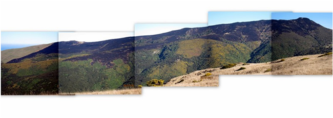
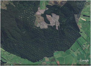
Hinewai fire highlights value of carbon sequestration insurance
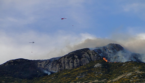 An unseasonal fire at Hinewai Reserve on Banks Peninsula has reignited discussion about the value of carbon sequestration insurance for afforestation schemes.
About a quarter of the 1230ha private reserve was affected by the fire, which was sparked by a lightning strike on 12 July.
Since 2005, Landcare Research’s EBEX21® service has been selling carbon credits from Hinewai Reserve on the voluntary carbon market.
Landcare Research Senior Technician Larry Burrows says some of the Hinewai Reserve carbon credits sold in 2005-2007 were from the area burnt.
“Fortunately it was a condition of the EBEX21 programme that all participating properties (including Hinewai) set aside 10% of their land area in a self-insurance scheme,” says Larry. “That pool of land retained by EBEX21 comfortably exceeds the area burnt at Hinewai.
“This fire does highlight the value of a self-insurance approach, something we have recommended in the recent review of MAF afforestation schemes as has been included in the report by the Review Panel.”
Hinewai fire assessment
 |
| Fire damage was mainly along the central ridge on Hinewai Reserve, predominantly in the youngest stands of gorse and away from most of the larger stands of trees in the catchments on either side. |
The EBEX21 team is now determining the impact of the fire on carbon stored at Hinewai Reserve. Our initial assessment is that the carbon lost from the area burnt is more than compensated on the property as a whole in a number of ways:
- In the burnt area there is a substantial amount of biomass remaining in the form of scorched gorse stems, and so although some biomass has been lost it is likely that total carbon stocks remaining are still at least those sold in the three Pre-Kyoto years (3 t CO2e/ha/yr, i.e., 9 t/ha remaining). The remaining biomass will need to be quantified.
- Gorse remaining within the burnt area is mostly still alive and will continue to sequester carbon as it sprouts afresh. We intend to re-inspect the mortality of the gorse and occurrence of native tree seedlings at Hinewai in spring.
- Credits have not yet been sold from the rest of the property for the period 2008‑2010 awaiting final registration with MAF within the Permanent Forest Sink Initiative (PFSI). Sequestered carbon on the unaffected offset forest land at Hinewai (~385 ha) is estimated at ~10 t CO2e/ha/yr and so offers a substantial buffer to any biomass lost.
- As already noted, the total amount of land retained by EBEX21 in the self-insurance scheme is well in excess of the area burnt at Hinewai.
The MAF registration application for Hinewai into PFSI has been revised. The burnt area has been mapped and will be entered as ‘not yet established’.
Further information:
Larry Burrows
Weed & Pest Management
Beating the beetle bug – new biocontrol agent for tradescantia
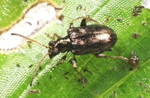 A frustrating two-year delay in releasing a biocontrol agent for one of New Zealand’s most widespread and problematic weeds, tradescantia (Tradescantia fluminensis), is now over.
Landcare Research got permission from ERMA to introduce the tradescantia leaf beetle (Neolema ogloblini) in New Zealand in 2008 but its release was delayed by the discovery of a gregarine gut parasite infecting the beetles held in containment.
For the past two years Landcare Research scientists have been working to eliminate the bug from the beetle populations.
Towards the end of last year three generations of gregarine-free beetles were achieved, resulting in MAF giving permission to release the beetles from containment.
Researchers beat the disease by adopting high levels of hygiene for adults and newly laid eggs, reducing the likelihood of infection, and low levels of hygiene for developing larvae kept in strict solitary confinement.
“By not keeping things too clean at this point any parasites that may be present are given the opportunity to build up to detectable levels in individual beetles, so we minimise the risk of failing to detect very low levels of infection,” says researcher Lindsay Smith.
“Any eggs or offspring from infected adult beetles can then be culled. All this information is recorded, e.g. we have full family trees for all of the leaf beetles and can trace each back to their great grandparents! This knowledge also helps us to reduce inbreeding by making selective crosses between different lines before release.”
Eighty pupae and adults were moved from Landcare Research’s containment facility at Lincoln to its Auckland site in late December. Mass rearing by Auckland staff led to the first release in an Auckland reserve recently. Widespread releases are planned for spring 2011.
As its name suggests, the tradescantia leaf beetle feeds on the foliage of the weed, which has become widespread in frost-free parts of the North Island and parts of the South Island. Thriving in shaded areas of gardens and bush, tradescantia grows densely on the ground preventing regeneration of desirable plants. Earlier research has shown that this weed is a threat to regeneration, and hence long-term survival, of indigenous forest in northern New Zealand.
Auckland Council has recently applied to ERMA for permission to release two further tradescantia agents that Landcare Research has been studying: the tip-feeding (Neolema abbreviata) and stem-boring (Lema basicostata) beetles, with a decision likely within 6 months.
Routine disease tests have found low levels of different species of gregarines in both beetle populations and Landcare Research is confident the methods used to rid the leaf beetle population of the parasite will also work for the stem-borer and tip-feeder beetles. Gregarine-free populations of both species should be available for release by the end of this year.
“We have pursued this trio despite the parasite problems because they attack different parts of the tradescantia plant (leaves, stem, stem-tips) and should make a complementary team,” says Lindsay.
“Defoliation experiments indicate that the sum effect of their feeding will be magnified in the presence of each other. Just wait until we get them out there!”
Meanwhile, work is continuing in Brazil with a fourth promising agent, the yellow leaf spot fungus (Kordyana brasiliense).
This project is funded by the Department of Conservation, National Biocontrol Collective and the Ministry of Science and Innovation under the Beating Weeds programme.
Further information:
Lindsay Smith
For more information about the tradescantia leaf beetle and other biocontrol news see the latest edition of What’s New in Biological Control of Weeds?
Rabbits on the rise
 It’s almost 15 years since the release of the rabbit haemorrhagic disease (RHD) which decimated rabbit numbers over large areas of New Zealand. However, in the intervening years rabbits have developed increasing immunity to the RHD virus and their numbers have started to recover.
Increased rabbit densities have led to resurgence in the use of conventional control tools, including baiting with either 1080 or pindone. Landowners are required to control rabbits when numbers exceed specified population levels and some landowners are again incurring high rabbit control costs.
Due to growing concern about the numbers of rabbits infesting our drylands, for the first time in more than 10 years Landcare Research scientists, led by Bruce Warburton, have received funding from the Crown to extend recent research on possum control to the control of rabbits.
The research has three main strands: (1) reducing the cost and amount of toxic bait used in aerial baiting, (2) identifying cost-effective strategies currently used by farmers for secondary control, and (3) understanding the toxicology of pindone poisoning in order to reduce the cost of application and its potential impacts on non-target species.
As a first step, published papers and reports from previous relevant research were catalogued within a searchable web-accessible bibliography (http://rabbits.landcareresearch.co.nz). The catalogue helped identify key research that could be used to update current best practice for controlling rabbits with aerially sown 1080-carrot bait. Such control typically involves sequential sowings of 20–40 kg each of prefeed (non-toxic) and toxic bait per hectare, depending on rabbit density, and costs up to $100 per hectare. Based on research into baiting for possums, Bruce believes that current bait sowing rates and associated control costs for rabbits can be significantly reduced.
To test this hypothesis, Bruce and his team are working with Otago Regional Council staff to develop and run a series of trials this winter to test a range of different bait sowing rates and applications that could reduce costs by as much as 50% and the sowing rate of bait by 66%.
Some farmers undertake secondary control of rabbits to slow or halt population recovery. To determine how control is currently being carried out, farmers are being interviewed to identify the control methods they use based on variations in habitat, percentage cover, farming practices, and the density of rabbits on their property. Preliminary results show that investment in rabbit control varies greatly; some farmers have long-standing control programmes costing tens of thousands of dollars per year, whereas others invest very little, instead relying on the RHD virus and the even the efforts of meat shooters to suppress rabbit numbers.
Farmers and rabbiters engaged in control use a wide range of tools to limit rabbit populations. Shooting is the most common control method used, though its application varies. For example, in areas where access by 4WD or motorbike is possible, night shooting is effective when rabbit densities are low. On steeper, less accessible country, rabbits are shot from helicopters. Other complementary methods include fumigation of burrows and patch-poisoning with pindone.
Pindone (a first-generation anticoagulant toxin) is used by some farmers and contractors to control rabbits because of the regulatory and stock-withholding-period requirements when using 1080. However, as with other pesticide uses, baiting with pindone raises concerns over toxin residues and risk to non-target species, but far less is known about these aspects of pindone use in comparison to 1080 use. Landcare Research toxicologist Penny Fisher has been assessing the residue concentrations of pindone in tissues from caged rabbits after they have eaten a lethal amount of pindone and has found relatively high levels of the toxin in rabbit liver and fat. Tissue testing is ongoing, and the final results will be used to review assessments of risk to non-target species that prey on or scavenge rabbits and to help optimize the application of pindone baits to both minimize costs and secondary poison risks.
Further information:
Bruce Warburton
This article originally appeared in the latest edition of Landcare Research’s vertebrate pest research newsletter, Kararehe Kino.
Native Forest Management
Beech forest stability and regeneration following harvest
Almost 20 years on from legislative changes to the way indigenous beech forests are harvested, a Landcare Research review has found that with appropriate management systems, harvesting can take place without affecting the health of remaining trees in a forest.
 |
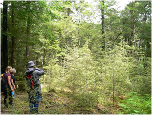 |
| 0.5 ha coupes of silver beech harvested in Woodlaw Forest, Southland. | Group-selection 10 years after the 1998 harvest of red-silver beech at Station Creek, north Westland. |
“Indigenous forestry has long been a controversial issue,” says Ecosystem Processes Science Team Leader, Rob Allen. “There is an estimated 166,000 ha of beech forest types in private ownership in New Zealand that are suitable for commercial harvest. A key issue is whether timber can be extracted while maintaining or even enhancing the non-extractive benefits of these forests, such as biodiversity, water quality, carbon and cultural identity.”
In 1993, Part 3A of the Forests Act 1949 was passed requiring harvested areas in beech forest to be no greater than 0.5 ha, unless specific approval has been obtained for a larger area (up to 20 ha; Ministry of Agriculture and Forestry 2007). Further, regeneration must have reached a predominant height of 4m, and a stocking of the harvested species equal to or greater than pre-harvest levels, before adjacent harvesting could occur.
Rob assessed and summarised studies of seven forests/trials where beech trees have been harvested, in accordance with 1993 legislation. “We studied what was known about the direct influence on tree recruitment, growth and mortality, and, where studied, on other natural values.
“Some general conclusions can be made about the management systems used. Quantitative assessments show harvesting operations do not always elevate mortality rates of remaining trees and observations suggest that, with the exception of coupes harvested in black beech, the systems have not so far dramatically impacted on residual tree mortality.”
The assessment contrasted with reviews of beech harvesting prior to 1993, where intended low-impact extraction often caused significantly elevated tree mortality.
Rob says harvesting since 1993 has typically led to prolific forest regeneration at a range of locations, especially following group or coupe harvesting. The > 4 m height requirement for adjacent harvesting has often been achieved in about 10 years.
“Prolific regeneration in homogeneous patches favours the development of long clean straight trunks by natural competition but, eventually, it can lead to stagnant growth of individual trees and compromise stand stability. Thus there is currently some interest in improving tree growth and product quality through thinning and pruning the dense regenerating stands.
“So far these management systems outlined have only been assessed over a small part of the beech management cycle, and further issues will be resolved through time. For example, whether the group-selection system in red-silver beech forest, or the selection harvest in silver beech forest, will provide adequate canopy openings for a regenerative response to reach the canopy, in the face of lateral expansion of the residual tree crowns, remains unresolved.
“This could have important consequences for coexistence of canopy tree species in red-silver beech forests. Superimposing small-coupe and group management systems on relatively even-aged second-growth beech forest may well lead to some attributes of old-growth forest such as structural complexity, presence of several cohorts of trees, and variation in tree size. However, there is also some evidence that these systems create opportunities for short-lived early successional species (e.g., tree fuchsia and wineberry) rather than the late successional, shade-tolerant species often associated with old-growth forest.”
Rob says that to some degree, the varying responses to different types of management reflect the context within which the management was applied, rather than the management itself.
“For example, trees found on fertile soils, where canopies intercept much of the light, exhibit strong competition with neighbouring trees when compared with trees found on infertile soils.
Further information:
Rob Allen
This review was funded by the Ministry of Science and Innovation. Much of the site research on the impact of beech harvesting was funded by MAF.
Please note: The newsletters are to keep MAF informed about current research projects. The news items may include interim results that have not been peer reviewed. They should not be disseminated or quoted without first contacting the person mentioned at the end of each item.