Issue 3, December 2012
In this issue:
|
|
Editorial
Welcome to our latest edition.
The fact that 10% of New Zealand’s highest quality land is now occupied by lifestyle blocks was highlighted in a media release we put out last December. Our research showed the number of lifestyle blocks had increased from 100,000 to 175,000 in just 13 years.
The story ‘grew legs’ and was picked up by general media, farming news outlets, lifestyle block magazines and others. That media release and the ensuing discussion has continued to surface in the media through most of this year, and we know it is of interest to many of you.
The discussion has focused on whether this growth in lifestyle blocks has been positive or negative in terms of productivity and the reinvigoration of rural communities.
We raised the profile of this issue to highlight that there are no effective, nationally consistent, measures to prevent the gradual loss of highly productive land to urbanisation and subdivision. This is now being addressed through a new two-year Envirolink tools project, outlined in this edition, to help develop consistent national guidelines for monitoring land fragmentation.
Also in this edition, we link to a video on promising biocontrol work to counter broom, one of our most persistent weeds. Many hillsides in Canterbury are a sea of yellow with flowering broom at the moment and, alarmingly, the weed is believed to exist in only about 20% of its potential range.
Plant pathogens are one way to counter invasive weeds, and we cover the opening of our new Plant Pathogen facility in Auckland. It is appropriately named after the late Dr Ross Beever and his wife Dr Jessica Beever, popular colleagues who have made significant contributions to conservation and biosecurity in this country.
We hope you find this edition interesting. It’s our last for the year, so I’d like to wish you all the best for the festive season.
Phil Hart
General Manager Science Investment & Evaluation
Land and Water
 New and improved ways of accessing land resources data and maps online
 New web services technology is allowing Landcare Research to provide people in government, industry, research and education sectors with new innovative ways to quickly and easily download environment data.
Back in 2010 we launched the LRIS Portal while last year we launched Our Environment and S-Map Online. These are “Google Map” like web browser applications making it easy to search, view maps and query environmental information on New Zealand’s land environments and soils respectively.
However, computer-based technologies are developing all the time and mechanisms now exist to stream maps and data direct to your desktop or third party web applications. These work in a similar way to how you stream video from the internet to your computer or TV rather than downloading the video first.
Landcare Research is therefore now able to provide facilities for automatically streaming spatial science data and maps onto your computer by using what are known as web services.
Web services support computer-to-computer data sharing, which means your desktop software and web applications can directly query and access our science data on demand. Up until the advent of web services, interoperability and integration (the exchange of data among computer systems) were extremely limited or cumbersome. Thanks to the development of open geospatial web services standards by the Open Geospatial Consortium (OGC)/ISO that has all changed.
Landcare Research provides two types of web services:
- Web Feature Service (WFS) for accessing vector data (points, lines or polygons). Accessible via the ‘Services’ tab on most data layers.
- Web Map Service (WMS) for accessing maps (images).
There are a number of significant advantages to using web services rather than downloading data from, say, the LRIS portal. These include: removing the need for you to store and manage data locally, access to the most up to date data and maps (you are always accessing the most recent version of the data we are making available), and you can easily use Landcare Research’s land resource maps and data in your own web browser applications overlaid with your own data or with data/maps from another organisation also providing WFS or WMS for the same location.
Web Feature Services
The LRIS Portal now supports Web Feature Services (OGC WFS) for accessing vector data. Unlike the more common OGC Web Map Service (WMS) that returns an image of a map, WFS returns actual features with geometry and attributes that you can use in any type of geospatial analysis. Through the use of what are called filters, WFS also allows you to perform spatial and attribute queries on the data.
More information on using WFS can be found at http://lris.scinfo.org.nz/p/api-support-wfs/
Web Map Services
Landcare Research started providing experimental web map services for some of our land resources data and background topographic maps just over a year ago, but these were not widely publicised because of concerns about reliability of the services under heavy demand. The Informatics team at Landcare Research has recently finished porting our WMS infrastructure to the Amazon Elastic Compute Cloud (Amazon EC2), a commercially available cloud computing service, and we can now scale our services as usage increases and offer high levels of guaranteed availability.
We have also taken the opportunity to add additional map layers, e.g., maps of the New Zealand Land Cover Database, and support for more maps projections. We also provide Cached Tile Services where the maps are all prebuilt rather than maps being created on the fly from data in a database. Using one of the supported tile cache service protocols allows our maps to be accessed faster. More map layers and support for more map projections, particularly support for the Google Maps projection, will appear in the near future.
Details on how to access the WMS and how to use it with various desktop GIS and web applications including Google maps can be found at http://maps.scinfo.org.nz.
Further information: David Medyckyj-Scott
Reviewing the spatial extent and land-use change of stony soils – are they a hotspot for intensification?
Stones don’t hold water or store nutrients and, other things being equal, the more stones in the soil the greater the potential for leaching of contaminants. With this in mind Landcare Research soil scientists are undertaking a national stocktake of the distribution, state of knowledge, and agricultural development on New Zealand’s stony soils.
Stony soils occur where soil depth is less than 45 cm to the underlying river- or ice-deposited gravels. The focus of this study is stony soils with potential for intensive land use, usually on land less than 15 degree slope.
With 1.68 million hectares mapped it is obvious that stony soils are extensive. Fifty three per cent of stony soils occur in the Canterbury region, 12% are in Otago, 9% in Southland and the West Coast, with the remainder distributed across the Tasman, Marlborough, Hawke’s Bay, Manawatu/Wanganui, and Wellington Regions (Fig. 1).
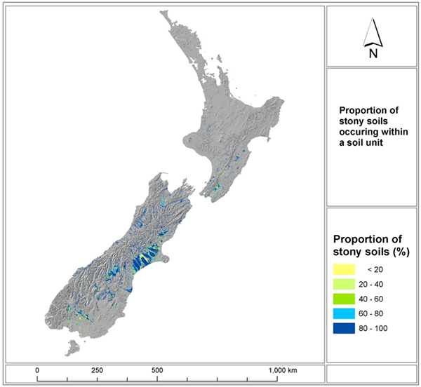 |
| Figure 1: Stony Soils occurring across New Zealand with the portion of stony soils contributing to each polygon unit. Occurrence of stony soils – colour shading indicate percentage of area composed of stony soils. |
The major land uses occurring on stony soils identified using Agribase 2012 are sheep and beef (427,000 ha), sheep (256,000 ha), and dairy (232,000 ha) and our research found significant land use change over the last decade.
Since the year 2000 sheep land use on stony soils has decreased by 38-43%, conversely sheep and beef has increased by at least 22-44%, and dairy land use by at least 47-95% (precise figures are precluded because of gaps in the Agribase data).
Most of the expansion in dairy land use on stony soils has occurred in the Canterbury region, more than doubling in area since the year 2000 to 143,000 ha in 2012. Similar expansion to dairying has occurred in the West Coast, Southland, and Otago regions, although the areas are smaller with 21,000 ha, 20,000, and 12,000 ha respectively in 2012. In Canterbury, irrigation is also extensive on stony soils, with analysis of satellite images collected from 2008-early 2011 estimating at least 196,000 ha under irrigation.
However, not all stony soils are the same, as shown in Fig. 2, where the depth of overlying soil and the nature of the fine earth material between the stones varying widely. The two left hand photographs show young stony soils with limited fine material (Fig. 2A and B), whereas the two right hand photographs are of older soils with increasing silts and clays between the stones (Fig. 2B and C). Stony soils span 10 soil orders, and 71 subgroups under the New Zealand Soil classification. Our analysis shows that 42% of stony soils have low P-retention (<30%), 77% have moderate to rapid permeability, and 58% have low water storage capacity (30-90 mm). These attributes are all indicators of soils with high vulnerability to leach nutrients.
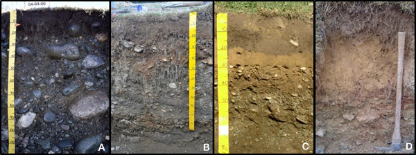 |
| Figure 2: Photographs of four different stony soil profiles showing (A), young alluvial very stony sand, (B), intermediate-aged terrace soil with very shallow sandy loam, (C), older terrace soil with shallow silt loam over sandy gravels at 45 cm, and (D) older terrace soil with loamy material in gravels to 1 m. |
Soil scientist Dr Sam Carrick says this research clearly shows that stony soils have been a hotspot for land use change and intensification over the past decade.
“We suggest that intensive land use on stony soils is creating conditions with high risk for leaching of soluble nutrients,” says Sam.
“These areas may need to have targeted management to reduce leaching losses. Future research will review previous studies related to stony soils, and assess major gaps in our understanding of hydrological and nutrient modelling for these soils.
“We also plan to conduct research on preferential leaching of microbes and phosphorus through the young stony sands (similar to the left picture of Fig. 2), which we suspect to be the stony soils with greatest risk of contaminant losses.”
Further information: Sam Carrick
Engagement key to Māori involvement in Auckland freshwater decision making
 Full iwi/hapū participation and collaboration will be essential for effective Māori involvement in freshwater management in Auckland, according to a Landcare Research report. The authors Garth Harmsworth and Shaun Awatere are leading a number of projects throughout the country using indigenous and western knowledge to resolve complex land and water issues.
Auckland Council asked Landcare Research to develop a suggested approach for integrating Māori values and interests into regional planning and management of freshwater to respond to the National Policy statement on Freshwater. Garth says strong relationships with a broad range of stakeholders are the key.
“The Council will need to recognise the iwi-centricity of Māori world views when engaging with iwi/hapū, and that each hapū or iwi have their own distinct customs, practices, values and planning traditions,” says Garth.
“What holds for one iwi/hapū may not be valid for another, although we have proposed some generic methods for future planning.”
Landcare Research participated in mana whenua workshops organised by Auckland Mouncil in Manukau and Orewa and led the work to identify iwi/hapū values and interests for freshwater management.
Shaun says participants raised many issues relating to the degradation of freshwater, impacts on cultural sites/areas, water allocation, the setting of baseline standards, the reconciling of different worldviews, defining property rights, the interfaces between regulatory regimes, land use practices, and the role of the water management agency, Watercare.
“A wide range of outcomes and aspirational goals were discussed at the workshops but three key themes emerged: empowerment of iwi/hapū, engagement, and the development of mātauranga Māori indicators for monitoring,” says Shaun
The researchers supplemented the workshop feedback with information from iwi and council plans, and good practice examples from around New Zealand and abroad.
“The council has sound plans and frameworks, and we have illustrated what has worked well elsewhere,” says Shaun. “The key is going to be the quality of the engagement.”
For further information: Garth Harmsworth and Shaun Awatere
Biodiversity
Step change in biodiversity assessment
 A new Landcare Research-led project will develop advanced new techniques to assess the state of biodiversity in New Zealand’s productive landscapes.
It’s envisaged that the work, in conjunction with Department of Conservation and regional councils, will bring about a step change in the efficiency and completeness of biodiversity assessment by enabling rapid and cost-effective assessment of all biota.
Biodiversity underpins critical ecosystem services but at the moment there is a shortage of criteria to assess biodiversity to indicate how our ecosystems are functioning in our productive land.
“At a time when we’re looking to achieve ‘green growth’ or ‘growth within environmental limits’, we need cost-effective monitoring techniques using biodiversity criteria developed from reliable, comprehensive data,” says project leader, Dr Robert Holdaway.
“Current methods for measuring terrestrial biodiversity rely on costly surveys and scarce professional labour, and focus on plants, mammals, and birds. Soil biodiversity, critical to the provision of ecosystem function (e.g. nutrient cycling and carbon sequestration), is neglected.”
The new project will develop state-of-the-art molecular techniques for rapid and thorough assessment of biodiversity and ecosystem function.
Using DNA extracted from a single pooled soil sample, the diversity of a minimum of 12 taxonomic groups, including both above- and below-ground organisms, will be assessed.
“Our novel molecular method will be integrated with the latest field monitoring systems for direct validation and comparison with existing techniques. So we will be able to set environmental criteria using cost-effective DNA-based metrics of terrestrial biodiversity and ecosystem function.”
“We will link these measures to ecosystem services by direct measurement of various ecosystem functions (carbon storage, nutrient cycling, and soil resilience to disturbance) within a model catchment. The response of biodiversity and ecosystem function metrics to land-use intensification will be used to produce an evidence-based minimal set of measures needed to set biodiversity criteria.”
Researchers will also determine statistically the least minimal amount of biodiversity information needed to effectively determine change in biodiversity criteria.
“We envisage that these new techniques and criteria will be incorporated into existing monitoring by productive sector organisations, regional councils, and the Department of Conservation. It will provide the evidence base needed for policy and the rigorous processes needed to support growth within environmental limits.
Further information: Robert Holdaway
Sustainable Development
National guidelines for monitoring land fragmentation to be developed
Land is a finite resource. Increasing competition among urban, productive and conservation uses could fragment land such that the resulting management units become unsuitable for certain types of activities.
Of particular concern are the potential impacts to our high class soil resources, says researcher Dr Daniel Rutledge.
“Those soils tend to occur near our larger urban centres and could be subject to increased urbanisation pressures associated with population growth,” says Daniel.
“While some regional councils have policies and practices in place to measure and monitor land fragmentation, the approaches taken and policies developed vary, making it difficult to understand collectively the state of our land resources across scales from local to regional to national.
“Therefore a national framework is needed to help understand the drivers and issues associated with land fragmentation and establish consistent methods to measure and monitor trends.”
In January Landcare Research and the Regional Council Land Monitoring Forum will begin a new 2-year Envirolink tools project to help develop consistent national guidelines for monitoring land fragmentation. The project will build a on a recent tools project that developed a tool to assist with land use classification and analysis by developing more specific capabilities to measure and monitor land fragmentation. To accomplish that goal the project has four objectives:
- Review policies and practices of regional councils and others (e.g., city councils, central government, etc.) currently undertake regarding land fragmentation.
- Develop guidelines and associated indicators that will help councils and others effectively monitor land fragmentation.
- Design and implement a tool to assist regional councils with monitoring and reporting land fragmentation in a consistent manner and on-going basis.
- Train regional council staff to use the tool and produce a set of first-generation land fragmentation reports for all regions across New Zealand.
This work will contribute to better use of our valuable soil resource as well as providing the information to inform policy development and future planning.
Further information: Daniel Rutledge
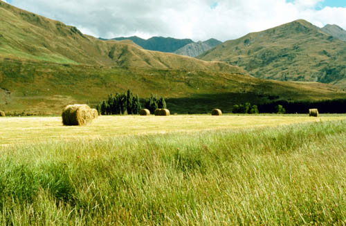
Strong views on Canterbury landscape preferences
Cantabrians have strong preferences for diverse rural landscapes and native shelterbelts, according to a new study.
Landcare Research studied whether Canterbury residents have noticed visual changes to the rural landscape in recent years, what changes they are particularly concerned about, and whether primary producers can adopt practices to mitigate those visual changes.
The research involved two focus groups, one with rural residents and one with urban residents, and an online survey in which 740 local people provided their responses to 43 photographic images of different rural landscape features across the region.
Lead researcher Pike Brown says the results showed that the majority of Cantabrians have noticed visual changes. Sixty-four per cent of urban residents viewed the changes as unfavourable, compared to 54% of rural residents.
“Dairy conversion is noted as a particularly prominent change,” says Pike. “Residents who believe that dairy farming is one of the two most important sectors for the Canterbury economy are less likely to perceive the visual impacts of dairy farming negatively.”
There is strong consistency among rural and urban Cantabrians about the rural landscape features they particularly like or dislike.
“They particularly dislike seeing dairy cows, irrigators, silage bales, gorse hedgerows and overgrown road verges. Conversely, Cantabrians particularly like seeing shelterbelts and individual trees. Native shelterbelts are preferred to exotic shelterbelts, but both are preferred to having no shelterbelts. Cantabrians also like seeing hills and mountains, horticulture, and sheep. Importantly, people appear to value visual diversity in the landscape.
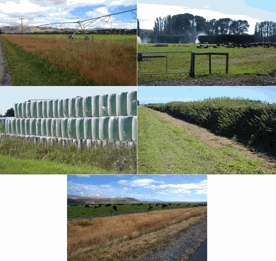 |
| Unfavoured views |
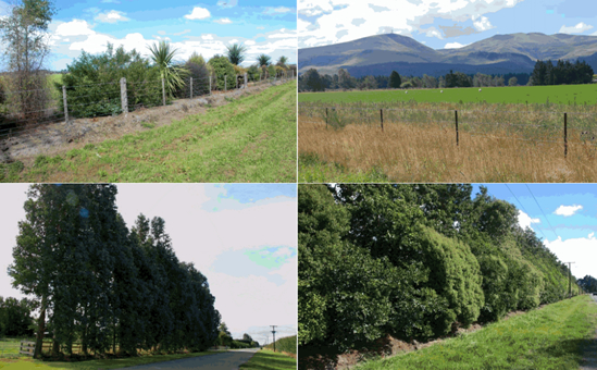 |
| Favoured views |
“Biodiversity matters to people, at least for choosing shelterbelts. Native shelterbelts were even more strongly preferred when survey respondents were informed that these have high biodiversity values, and exotic shelterbelts were less preferred when survey respondents were informed that these have low biodiversity values.”
The researchers came up with four conclusions and recommendations for Canterbury rural land managers:
- Maintain existing shelterbelts except where trees need to be removed to increase road safety or to create windows for views. Internal shelterbelts within paddocks should be maintained wherever possible, particularly on riparian margins.
- Increase the biodiversity value of existing exotic shelterbelts by under- or inter-planting with native plant species.
- Establish new shelterbelts with high biodiversity values. In order to provide visual diversity and increase biodiversity, new shelterbelts along roadsides should comprise a mix of plant species and a high percentage of those plants (at least 25%) should be New Zealand native. It is preferable to use locally sourced natural indigenous species rather than cultivars or hybrids that may have no nectar or fruit for wildlife. Recognised pest species should be excluded.
- Publicly promote on-farm planting programmes that increase rural biodiversity as biodiversity is important to Cantabrians. However, many people are unaware that mixed native shelterbelts provide greater biodiversity value than monoculture exotic shelterbelts.
Further information: Pike Brown
Spotlight on Māori land productivity
 Landcare Research has joined forces with Māori and primary industry-focused organisations to form the new Māori Land Productivity Initiative.
The eight-member initiative is a private sector response to the Māori Economic Development Panel’s recommendation to raise the productivity of Māori land.
The group’s goal is to review existing land productivity improvement programmes, align them where appropriate and ensure they are strongly targeted at the needs of Māori landowners.
In addition to Landcare Research, the group comprises the Federation of Māori Authorities, the Māori Trustee, Fonterra, Dairy NZ, Beef & Lamb New Zealand, ZESPRI and Massey University.
The Chairman of the Māori Economic Development Panel, Ngahiwi Tomoana, said an estimated 1.5 million hectares of New Zealand land was owned collectively or individually by Māori, but a 2011 Ministry of Agriculture and Forestry and Te Puni Kokiri report suggested that 80% of Māori freehold farming land was either underperforming or underutilised and not even close to reaching the land’s productivity potential.
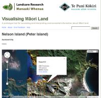
Landcare Research, which manages resources such as the Māori Land Visualisation tool, is pleased to be involved, says Chief Executive, Dr Richard Gordon.
“We are enthusiastic about contributing our science and information systems in sustainable land use, and our experience in working with Māori organisations to develop suitable land management and governance approaches.”
Further information: Garth Harmsworth
Weed & Pest Management
New plant pathogen facility to aid biodiversity and biosecurity
A new state-of-the-art plant pathogen (disease) containment facility marks a significant step forward in New Zealand’s battle against invasive weeds as well as destructive plant pathogens attacking species as diverse as kauri and kiwifruit.
The $2.2 million Beever Plant Pathogen Containment Facility was opened recently in Auckland and will boost Landcare Research’s weed biocontrol programmes which until now have had to rely on overseas facilities and collaborators to undertake trial work involving plant pathogens.
Biocontrol is a sustainable and environmentally friendly method of controlling weeds such as broom and gorse using other living organisms such as fungi, insects, and mites. Landcare Research staff have become world renowned for their expertise in this field.
“As well as weed biocontrol studies the facility will also be suitable for safely undertaking research into invasive plant pathogens that pose a threat to native flora and to crop plants. These include the PTA pathogen causing Kauri dieback, and the Psa bacterium devastating kiwifruit,” says scientist Stan Bellgard, who played a key role in the design of the facility.
The facility will also enable some biocontrol research that was previously not possible. For example, the Brazilian yellow leaf spot fungus (Kordyana sp.), which attacks tradescantia (wandering willie) and is being considered for release in New Zealand, requires plant to plant infection. Obtaining safe, clean material of the fungus for release could not be done without access to a containment facility in New Zealand, since none is available in the weed’s homeland of Brazil.
Although the facility will be primarily used to securely hold and study plant pathogens and their host plants, it can also be used to research insects and other invertebrates in containment if required.
One of the key features of the facility is the ability to grow plants in sealed glasshouses that meet a high level of safety and security of containment and provide natural light.
Other biosecurity and research organisations including the Ministry for Primary Industries (MPI), other CRIs, universities, overseas research institutes, businesses, and private individuals will also be able to use the facility.
The first ‘inhabitants’ - likely to be the Environmental Protection Agency (EPA) approved lantana rusts (Puccinia lantana, Prospodium tuberculatum) - should be in place prior to Christmas with releases beginning in the new year.
The facility is named in honour of the late Dr Ross Beever and his wife Dr Jessica Beever who have made significant contributions to fungal taxonomy and genetics, plant pathology, botany, and to conservation of New Zealand’s flora and fungi.
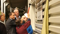 Video - Opening of the Beever Plant pathogen Containment Facility
Further information: Sarah Dodds
Battling Scotch Broom
At this time of year, in many parts of the country it’s hard to miss swathes of bright yellow flowers across large parts of the landscape. Eye-catching perhaps, but it’s evidence of the advance of a highly invasive pest plant.
Scotch broom (Cytisus scoparius) forms dense impenetrable thickets throughout most of New Zealand. It is unpalatable to livestock, shades out desirable pasture species, and has negative impacts on biodiversity and production forestry.
More concerning is that broom currently occupies only about 20% of its potential range and without improved control measures it will continue to spread. And, perhaps because of its bright, colourful and attractive features there is a good degree of public apathy to the plant and its impacts.
Furthermore, broom out-competes and displaces gorse which has often been considered New Zealand’s number one pest plant, says researcher Hugh Gourlay.
“Gorse is still a problem but it’s relatively stable in its distribution while broom is rapidly accelerating and is taking over large expanses of high country land,” says Hugh. “That’s hardly surprising given each plant produces up to 30,000 seeds per square metre, every year.”
Landcare Research is leading the use of biocontrols of broom and many of these agents are proving highly successful. Here is a short video about one agent, the Broom gall mite that was released just a few years ago in North Canterbury.
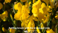 Video - Battling broom with the broom gall mite
Biocontrol offers a cost-effective, environmentally friendly, and permanent solution to weed control. Carefully selected biocontrol agents target only weeds, don’t harm desirable plants and don’t pollute the environment. Once established, they travel wherever the weed spreads and can return again and again to kill off new weed growth—all without human input.
Further information: Hugh Gourlay
Website: Biocontrol & Ecology of Weeds
Please note: The newsletters are to keep MPI informed about current research projects. The news items may include interim results that have not been peer reviewed. They should not be disseminated or quoted without first contacting the person mentioned at the end of each item.