Issue 1, July 2010
In this issue:
Editorial
Welcome to this first edition of our Landcare Research newsletter for local and regional authorities.
We are aware of the breadth of challenges confronting councils. We would like to use this newsletter to keep you informed of the new knowledge and tools arising from our research that might be able to assist you with these issues.
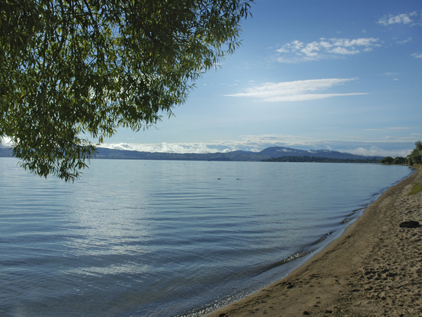
In this edition I’d like to focus on our work in just one area: water. You will be well aware of the economic, social, cultural and environmental importance of water, and the fact that many of the water-related management challenges we are facing are complex and intractable.
In this newsletter we highlight research on the attributes of good water governance; innovative options for water infrastructure options (including a new website to calculate costings); the control of sediment generation and erosion, alternatives for reducing nitrogen getting into lakes, and a comprehensive new guide to wetland restoration.
This e-newsletter is one of an array of initiatives we are taking to improve the way we communicate and engage with key customers. I hope you find the content useful and I would welcome your feedback on how we can improve the newsletter to meet your needs or any aspect of the research reported in this edition.
Best wishes,
Warren Parker
Chief Executive
Twenty attributes of good water governance
 Water governance is one of New Zealand’s most challenging and complex environmental issues. So what does it take to effectively manage our water resources?
Landcare Research Programme Leader, Andrew Fenemor, and counterparts from The Netherlands and Germany have developed a list of 20 attributes for good water governance.
The attributes were derived from questionnaire responses and structured interviews of 56 stakeholders, each involved in one of five South Island Resource Management Act (RMA) catchment management planning and implementation processes: the Waimea Catchment in Tasman; the Awatere Catchment in Marlborough; the Waimakariri Catchment in North Canterbury; the Waitaki Catchment in South Canterbury; and the Pomahaka Catchment in Otago.
Questionnaire results provided a Strengths-Weaknesses-Opportunities-Threats (SWOT) analysis of the likely effectiveness of each of the five water management planning processes achieving their Environmental Results Anticipated (ERAs). Follow-up structured interviews explored stakeholder views about the barriers to achieving ERAs and institutional shifts that could achieve better outcomes through both planning and implementation phases.
Stakeholders were grouped into government, environmental, iwi, water users and instream sectors. Their responses led to the development of a 3-D governance evaluation matrix allowing assessment of the degree of overall satisfaction with each plan and each sector’s degree of satisfaction with the planning process.
Stakeholder observations
These are some specific observations from stakeholder sectors from which the more generic attributes were developed:
- Plan for land and water together at catchment scales; more holistic planning is sought especially by iwi who mostly do not feel well engaged in water management processes.
- Land–water (catchment) management requires not just water body standards and limits, but also direct limits on some land-based activities and uses (‘Emission Limit Values’).
- Planning processes are not keeping up with management needs, especially in addressing water quality decline.
- Stakeholders need confidence in the science upon which plans are based; making science widely available in an understandable and concise form helps engagement.
- Water users need to have formalised involvement in planning and implementation; but engage other stakeholders too, to avoid marginalising other stakeholder values – examples cited were landscape, spiritual and amenity values.
- Better approaches are needed for balancing diverse values in catchment planning.
- Engagement of stakeholders in planning processes needs continuity and focus; fragmentation and long planning processes can erode trust among the parties, while tight time frames can also disenfranchise some stakeholder groups.
- Communication and engagement of water users and key stakeholders in decision-making during low-flow periods creates cohesion and confidence in the water management regime.
- Water users would like consent renewals to be made less bureaucratic.
Conclusions
The 20 Good Governance Attributes for New Zealand water management planning are:
- Determine the actual carrying capacity of water bodies and the desired carrying capacity to meet the present and future needs of the community
- Have good and timely communication between the full range of stakeholders and the regional council at the early stages of planning
- Attune to the whole instead of segment of the whole in catchment management decision making
- Have clearly connected and defined objectives, policies and methods/rules in the plan
- Provide a clear and concise allocation framework through the three principles of sound water management: environmental flows, flow sharing above that bottom line, and allocation caps
- Avoid political bias in environmental decision making
- Consult regularly and have continuous two-way communication with stakeholders during plan process and implementation phases
- Peer review science and share intellectual knowledge
- Use up-to-date science and monitoring in decision making
- Plan for and incorporate transition between planning process phase and implementation phase
- Facilitate buy-in to plan from anyone administering or implementing it
- Foster team approach to water planning and management within councils
- Produce over-arching resource management vision, with generic national priorities on sustainable water management
- Devolve monitoring to stakeholders within a defined management framework to achieve shared goals
- Build in flexibility to the plans and planning processes to respond to new pressures and achieve defined objectives
- Help achieve planning goals through adaptive management
- Monitor effectiveness and efficiency of plans by measuring them against identified values
- Hold regional councils accountable to a higher regulatory authority for their effectiveness and efficiency of plans and implementation
- Ensure water quality targets influence land-based planning
- Spread the burden of water management costs among users
Further information:
Andrew Fenemor
Web: http://icm.landcareresearch.co.nz
Innovative Infrastructure
Urban growth is creating water supply and stormwater management challenges for our local authorities. Innovative, environmentally friendly infrastructure options can take pressure off traditional systems, as researcher Robyn Simcock explains.
Municipal reticulated water supplies are very costly and as houses grow larger and sections grow relatively smaller the resulting increase in impervious areas means the volume and speed of stormwater entering streams is often increased. More environmentally sensitive and cost-effective options are needed to minimise impacts of this stormwater runoff.
Integrated urban water management – linking the management of urban water supply, stormwater runoff, and wastewater with the management of natural urban waterways and water bodies – embodies the principles of Low Impact Urban Design & Development (LIUDD).
Rain tanks
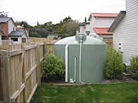 As communities have become larger and more centralised, community water treatment and distribution systems have gradually replaced the collection of rainwater and use of shallow wells as our primary water supply. As we have begun to understand the need for sustainable use of water worldwide there has been a renewed interest in collecting rainwater.
The central functions of rain tanks are to reduce stormwater peak flows and/or supplement stream base (low) flows, thereby protect natural urban waters and/or reduce demand on the reticulated water supply, particularly the use of potable water for non-potable uses (gardening, toilets).
The LIUDD research programme (link) found that Auckland’s climate can provide enough water to meet needs in commercial and residential buildings. A commercial building can meet its full needs if the rainwater tank overflow, combined with uncollected roof water, exceeds the demand from reticulated services.
In a typical Auckland house, which currently needs approximately 240 m3 per year of reticulated water, a rainwater tank can collect 180 m3 per year on average. Simple demand management technologies such as low-flow fixtures, along with accounting for reduced leakage in rainwater tanks (relative to a reticulated system), can make up the difference.
There is also evidence that rainwater tanks provide educational benefits to the community on the availability of water. Residents using rainwater tanks report increased awareness of water consumption, and, if supply is low, can change their behaviour to reduce demand. Besides water quantity, users of rainwater tanks are also concerned with the health impacts of rainwater consumption. While there have been relatively few disease outbreaks linked to contaminated roof rainwater, literature reviews identify that following best-practice system design and best-practice maintenance schedules reduces the level of pathogens and other contaminants entering rainwater tanks.
Work by our senior researcher, Nalanie Mithraratne has provided more insights into the life-cycle costing of rain tanks when compared with reticulated supply. A life-cycle costing study that included the benefit of foregone investment in upgrading existing stormwater infrastructure to cope with increased development found that conventional and LIUDD approaches were similar, but found the LIUDD approach also represented an investment in innovation.
A study that looked only at water-supply benefits showed that continued investment in reticulated water supply LIUDD (including an increased level of demand management) can be up to 80% more costly than investment in rain tanks for supply if the ongoing benefits of water savings are included. Not all infrastructural costs are financial. Energy and greenhouse gas emission costs have also been studied using life-cycle analysis.
Over a 100-year period, concrete rainwater tanks consume the least amount of energy, while reticulated supply (with demand management technology) emits the fewest greenhouse gas emissions. This demonstrates the complex trade-offs that must be considered when planning infrastructure, especially as the most expensive, most energy consuming, and highest greenhouse gas emissions were calculated in the hybrid scenario where investment is made in both reticulated supply and rainwater harvesting.
Vegetated swales
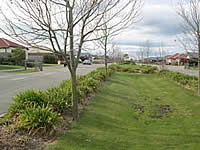 Swales – or biofilters – are vegetated areas that connect roads to grassed verges by replacing kerb and channel or paved gutters. These transport stormwater runoff, slowing runoff and filtering out coarse contaminants. Biofilters can be designed to infiltrate road runoff into the soil.
Vegetated swales can serve as part of a stormwater drainage system and can replace kerbs, gutters and stormwater systems. Swales are best suited for residential, industrial, and commercial areas with low flow.
Swales reduce peak flows, remove pollutants, and can promote runoff infiltration. They tend to have lower capital costs than curb and channel but can have higher maintenance costs. While swales are generally used for stand-alone stormwater management, they are most effective when used in conjunction with infiltration strips, rain gardens wetlands and/or wet ponds.
Rain gardens
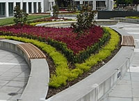 Rain gardens, preferably planted with native plants, are strategically located to collect, infiltrate and filter rain that falls on hard surfaces like roofs, driveways, alleys, or streets to minimise the negative impacts of excessive runoff and contaminants from these surfaces on lakes and streams.
Rain gardens – a bioretention device – are designed to intercept water that comes off a roof or paved area before it enters the piped stormwater infrastructure.
There is no standard size for a rain garden. One formula provides that the bioretention area should be 5% to 7% of the drainage area that the rain garden is intended to accommodate and they work best when close to the source.
Green roofs
Green (or living) roofs are increasingly being legislated for and promoted around the world.
They are effectively a thin planted layer on top of a building, house or other structure (most commonly water reservoirs, pump stations and carparks) to achieve maximum stormwater and energy benefits while keeping additional structural costs to a minimum.
New Zealand has very few thin green roofs currently, but local lightweight substrates, suitable plants, and the benefits for stormwater and biodiversity have been quantified as part of the LIUDD programme.
Using roof space for growing plants has the major benefit of not competing with highly valuable ground-space, while adding value to underutilised space that generates most of the stormwater, reflected heat, and ugly views in a city.
Green roofs are very popular in North America, Asia and Europe to reduce the impacts of flashy stormwater runoff that creates combined sewer overflows to beaches and rivers, reduce building energy demands (through insulation and increased efficiency of air conditioners) and city summer temperatures (for health benefits and control of peak summer energy demand). The research programme also started investigating the potential for green roofs to be urban pest-free ‘islands’ for conservation of our flightless lizard and insect fauna.
Green walls
Green walls, vertical gardens and living building facades, whether free-standing or fixed to a wall, reclaim often disregarded and neglected city spaces (walls and fences) with minimal adverse effect on ground-level usable area. They supply large areas of cooling, insulating and filtering surfaces for a negligible building footprint. This technology has rapidly grown over the last five years with the development of cable and modular trellis systems, and higher maintenance vertical gardens.
Further information:
Robyn Simcock
How much do low impact stormwater options cost?
 A new web application that compares the whole-of-life costs of alternative low impact stormwater devices will aid decision making about environmentally friendly stormwater management options.
COSTnz (Cost of Stormwater Treatment in New Zealand) has been developed by Landcare Research as part of the LIUDD (Low Impact Urban Design and Development) programme.
‘It was clear that for local authorities to determine the most appropriate stormwater treatment they needed to understand both the short- and long-term costs incurred as a result of construction and maintenance,’ says Landcare Research environmental economist Eva Vesely.
‘COSTnz allows users to identify and combine acquisition, routine and corrective maintenance, and decommissioning costs to determine the full life cycle cost.’
Modules are available for ponds, rain gardens, wetlands, swales, filter strips, rain tanks, sand filters and infiltration trenches, plus a generic module enables the same analysis for various proprietary devices. Users can select from a range of default values for the cost elements, or input data from their own suppliers or historical information.
COSTnz uses a unit costing approach based on locally collected data, supplemented for a number of devices with statistical relationships for the total acquisition costs. It includes the option for discounting so that the present value of future costs can be estimated at the base year.
The set-up of the modules allows sensitivity analysis for a range of assumptions, such as lifespan of the device, different maintenance regimes, unit costs and a range of real discount rates.
Dr Vesely says COSTnz will improve understanding of long-term investment requirements and assist local authorities in their budgeting, reporting and auditing processes.
‘It will also help low impact urban design and development decision-makers make more cost-effective choices at the project scoping phase and provide a platform for negotiations between councils and developers regarding financial contributions,’ she says.
Now commercially available, COSTnz is targeted at asset managers, consultants, developers, designers and regulators. The Web application (www.costnz.co.nz) follows a logical approach with consistent layout, and is designed to be flexible and easy to use.
Results are delivered in a PDF report format or as an Excel spreadsheet that enables users to develop the costing of a full treatment-train or input data into other systems.
Further information:
Eva Vesely
Web: www.costnz.co.nz
Improving lake water quality
 Landcare Research science is providing independent, evidence-based support for the policy changes necessary to reduce nutrient levels in the Rotorua Lakes.
Environment Bay of Plenty (EBOP) aims to remove about 310 tonnes of nitrogen from Lakes Rotorua and Rotoiti over the next 200 years.
‘While plenty of people have opinions, very few have robust analysis of the options available and their comparative cost, benefit, efficiency and effectiveness,’ says Kataraina Maki of EBOP. ‘Obviously, we need a range of ways to reduce nutrient levels and to be sure that the ones we choose are the best ways.’
Dr Suzie Greenhalgh of Landcare Research undertook a comprehensive review of interventions that could be used to reduce the amount of nitrogen in the lakes: water quality trading, cost sharing, reverse auctions, land stewardship and land retirement.
- Water quality trading or nutrient trading involves a market that trades reductions in nutrients. It is premised on the fact that the costs to reduce nutrient losses differ among individual entities depending on their size, scale, location, management. Trading allows sources with high nutrient reduction costs to purchase reductions from sources that have lower reduction costs. Entities with lower reduction costs are economically able to lower their nutrient discharges beyond regulated or permitted levels enabling them to sell their excess reductions to entities with higher costs.
- Cost share payments typically cover some or all of the start-up and installation costs of implementing a less polluting practice and are used to encourage individual landowners (i.e. nutrient sources) to adopt pollution control practices that require capital investment. Like a subsidy, the cost of a nutrient-reducing management practice is shared between a nutrient source (e.g. landowner) and government.
- Reverse auctions are a mechanism that can be used to cost-effectively allocate funding. They differ from standard auctions in that they have one buyer and many sellers. In reverse auctions, participants have an incentive to reveal the minimum compensation they are willing to accept to adopt or change management practices. Willingness to accept, which only the participant knows, is important information for an administrator of a reverse auction as they want to purchase the most nutrient reductions they can for the available funding. By making selection competitive, the producers have an incentive not to inflate their bid price much beyond the minimum price they are willing to accept as this may lead to their bid being unsuccessful.
- Stewardship approaches such as memorandums of understanding, memorandums of encumbrance or accords are typically agreements between organisations to undertake a set of specified activities. In this case, they will usually involve agreements to change farm management practices.
- Land retirement is where an entire farm or portion of a farm is retired from agricultural use. Dr Greenhalgh then assessed the strengths and weaknesses of each intervention as well as their impact, reach and cost-effectiveness.
‘We laid out some of the decisions EBOP would have to make in terms of getting things in place or in design of the interventions, as well as outlining some of the compliance issues the council might have to face, the infrastructure they’d need to support the interventions and some of the decisions they’d need to make on an ongoing basis and within any regulatory framework.’
The conclusions were that no single intervention was going to fully solve the problem. Rather, a suite of interventions is likely to be required to achieve the required reduction in nutrients in the lakes.
The information is now being used to educate councillors, staff and stakeholders as EBOP moves to clean up the lakes.
‘I wanted efficient and robust analysis,’ says Kataraina Maki. ‘Landcare Research undertook all that in a robust way and their experience and skills brought it to life.’
Further information:
Suzie Greenhalgh
Planting to avert erosion
Further afforestation of gullies in the Gisborne region will be critical to saving vast areas of productive hill country and reducing catchment sediment yields, a group of Landcare Research scientists recently told the Gisborne District Council.
“More than 800 actively eroding gullies in the region are contributing about half of the abnormally high sediment yield of local rivers says Dr Mike Marden, a local Landcare Research scientist who along with colleagues Drs Chris Phillips and Alexander Herzig presented findings from recent erosion-related projects.
Dr Alexander Herzig’s modelling predictions for sediment yield under different afforestation scenarios showed that sediment derived from gullies will more than double in the next 40 years if nothing more is done to stabilise them. Dr Chris Phillips says a ‘mosaic’ of planting would be the best option for stemming erosion. “What’s required is not all trees or all grass but a mixture of close-planted forests, pastured areas, and space-planted trees.”
Topics covered in the council presentation included the history of gully erosion and its contribution to sediment yield, predicting sediment yields from gullies under different afforestation scenarios, bank erosion measurement and erosion mitigation by vegetation.
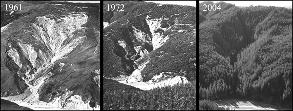 |
| The effectiveness of gully reforestation is evident in these three photos of the same gully, taken between 1961 and 2004. |
Gully erosion
Despite good gully erosion control now being achieved through reforestation of 135,000 hectares of exotic forest since 1960, the wider Gisborne region has still suffered a 27% overall increase in area effected by gully erosion, a 2007 study found.
This is because gullies present on farmland 40 years ago, but never planted, have increased in size, and new gullies have formed over this period as well.
Dr Marden’s work has shown that reforestation of gullies successfully closes down all but the largest features. However the early targeting of gullies could have prevented the loss of significant productive hill country. Gullies, both treated and untreated combined, have affected a staggering 100 square kilometres of hill country in this region.
Dr Marden says gullies are the single largest source of sediment and until sediment production from them is halted, suspended sediment yields in the East Coast river systems will remain abnormally high for many decades to come.
For the period 1957-1997, gullies contributed the equivalent of 43%, 49% and 54% of the average annual suspended sediment yield of the Waipaoa, Waiapu and Uawa rivers, respectively. This sediment came from just 0.8%, 2.4% and 1.7% of hill country areas in these respective catchments.
He warns that the remaining untreated gullies will inevitably increase in size and add significantly to the sediment load.
The region has more than 800 actively eroding gullies (excluding those in indigenous forest) that require treatment. The longer treatment is delayed, the higher the costs of restoration in the future and the greater the on-site and off-site consequences, particularly to the region’s infrastructure.
Gully modelling
Landcare Research’s gully modelling has shown that past afforestation was effective in reducing current sediment yield compared to not having afforested at all. The Waiapu catchment sediment yield is 17% lower and the Waipaoa reduction is 33%.
The models show that of the two afforestation plans for the region, MAF Target Land plan would be more effective at reducing sediment yield than the Gisborne District Council’s Land Overlay 3A area. However, the most effective way to reduce future sediment yield is to afforest all gullies (and sub-catchments) irrespective of size and if this were done for all existing and every newly initiated gully in the Waiapu catchment by 2020, then the sediment yield will halve by 2050 from 22 million tonnes to 11 million tonnes per year.
The modelling also shows that if there is no more afforestation of the present and newly initiating gullies in the Waiapu catchment then the sediment yield will more than double by 2050 from 22 million tonnes to over 45 million tonnes of sediment per year.
Bank erosion
Bank erosion contributes to river sediment loads; in fact it can be a major contributor. Measurements from cross-sectional surveys of the banks of the Waipaoa River following Cyclone Bola indicated that bank collapses of more than 20m in width, and in some cases 65m wide, were common during this single, albeit massive storm.
There have been very few New Zealand studies quantifying bank erosion and evaluating its contribution to sediment loads and budgets, and impaired water quality.
Dr Ron De Rose of Landcare Research is developing models of bank erosion to incorporate into water quality models, and has set up trial sites along two reaches of the much-studied Waipaoa River.
The sites were selected because of the extensive existing research into the geology, hydrology, land use and erosion processes in this region, and because of the availability of a LIDAR (Light Detection and Ranging) survey captured in 2005. LIDAR is an optical remote sensing system used to collect topographic data. Aircraft-mounted lasers record elevation measurements with a vertical precision of 5 centimetres.
Previous research experience in the area and historical aerial photographs from the 1950s in conjunction with LIDAR enabled the researchers to plot the previous location and elevation of river banks.
The analyses showed that the mass of sediment produced from cliff erosion in the gorge area is seven times that coming from alluvial banks. The combined contribution from bank and cliff erosion is not large in percentage terms (<1.5%) because very extensive gully erosion dominates the sediment budget of this catchment.
Nevertheless, the research has significant potential application to rivers elsewhere in New Zealand.
Erosion mitigation using vegetation
Vegetation mitigates erosion in two ways: by changing the hydrological regime and through tree roots reinforcing soils, thereby increasing the soil’s shear strength.
We know that close planted slopes have fewer landslides than grassed slopes – trees prevent erosion. Close planted trees can control gullies if they are treated early and earthflows can be slowed.
The long-term solution to erosion prevention in places like the East Coast is to have a mosaic of land use across the landscape, i.e. not all trees or all grass but a mixture of close-planted forests, pastured areas, and space-planted trees.
Native plants do develop good root systems but they are not as fast growing as some exotic species.
Root studies of native plants indicate that there is significant variation in below ground appearance – in much the same way that native trees look different in their above-ground appearance.
For bank erosion control, non-woody species such as flax, carex and toe toe have many more roots and are likely to be more effective in the short term.
Further information:
Mike Marden
Chris Phillips
What’s to blame for sediment generation – big storms or land use change?
 Large, powerful, infrequent storms as well as changes in land use are both major drivers altering the rates of sediment generation and delivery into rivers and the ocean.
Debate has raged over which is more damaging, but there have been few studies where the impacts of the two have been compared.
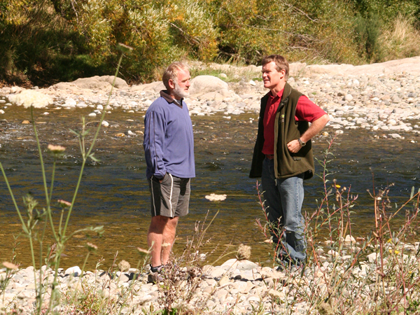
Over the last few years Les Basher of Landcare Research and NIWA colleague Murray Hicks have been monitoring sediment yield at seven sites in the Motueka River as part of Landcare Research’s Integrated Catchment Management (ICM) programme.
‘To measure sediment yield we continuously measured turbidity and took water samples during storms to get a time series of suspended sediment concentration. This was combined with flow measurements to estimate sediment yield for each storm event. Longer term sediment yield was calculated by summing the storm yields,’ says Mr Basher.
At all sites annual yields were dominated by a few large events which carried most of the suspended sediment load. At all sites also there was a very strong relationship between sediment yield and peak flow during each storm.
A significant storm in the headwaters in March 2005 dumped 160 mm of rain in 4 hours causing severe gully and bank erosion. It also increased sediment concentrations and yields by 10–20 times in the affected headwaters while almost 100 km downstream there was still an increase of 2–3 times.
Sediment yields have slowly decreased over the years since that storm – at some sites yields are similar to what they were before the storm while at others they have remained higher.
Harvesting of exotic forest produced a five-fold increase in event sediment yields and they recovered to pre-harvesting levels in under 5 years. However, these sites did not experience any large storms during the measurement period.
Mr Basher says that land use change was an important influence at small catchment scale but the extent of the yield increase, the time to recover, and the total area affected tended to be smaller than the impacts of the large storm in the headwaters.
‘The large storm was a “threshold” event that perturbed the erosion regime and activated sediment sources.
‘This caused subsequent smaller, more common runoff events from these tributaries to carry sediment loads that were over an order of magnitude larger than those events would normally have carried. This effect extended right down the catchment to the coast. Similar results have been found in other catchment studies and have important consequences for calculating long-term sediment yield,’ says Mr Basher.
Further information:
Les Basher
Web: http://icm.landcareresearch.co.nz
New guide to wetland restoration
 New Zealand’s notoriety as a world leader in the destruction of wetlands is now being matched by leading expertise in the restoration of these critical ecosystems.
Over the last 150 years we have lost a staggering 90% of our wetlands, and many remnant wetlands continue to be under pressure from land-use intensification and urban growth.
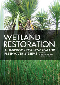
Fortunately attitudes are changing and a new book, ‘Wetland restoration: a handbook for New Zealand freshwater systems’, co-edited by Dr Bev Clarkson of Landcare Research, is an authoritative guide for forward-thinking landowners, community groups, schools, agency land managers and non-government organisations who are now restoring wetlands.
“The handbook brings together expertise from specialists and groups actively engaged in restoring wetlands throughout the country,” says Dr Clarkson. “It provides a detailed, comprehensive ecosystem approach toward understanding, protecting and enhancing our remaining wetlands. It is targeted at those who plan to, and those who already are making a difference to improving wetlands, and is written in a way that can easily be understood and importantly, acted on.”
The problem
Most of our major cities are built on wetlands. Coastal and inland wetlands were drained, reclaimed, destroyed, and built-over to support a growing, land-hungry population. That loss continues today. The majority of wetland remnants are highly degraded and the unique biota dependent on these ecosystems is under threat. Land-use intensification has both increased the demand for fertile land and nitrogen-rich runoff has exacerbated eutrophication processes affecting wetland biodiversity and ecosystem functioning.
The response
Thankfully many people are now recognising that wetlands are not a waste of space. Wetlands are nature’s tools for maintaining water tables, filtering and recycling waste, pollutants, nutrients and sediment washed from the land. Changing attitudes and land-use practices developed over several generations can be challenging, particularly if there is no clear path to the outcome desired or examples to follow.
But change is occurring. Wetlands are being restored to capitalise on their natural attributes and more sustainable land use practices are being applied. Objectives vary widely between projects but the overall goal is clear: to return degraded wetlands back to what they once were - healthy, living ecosystems. Restoring wetlands instead of destroying them inevitably requires new skills, knowledge, and time to learn and apply that knowledge.
The new handbook is timely for guiding new projects as well as providing additional useful information for projects already under way. It focuses on restoring ecosystem function in naturally occurring wetlands for long-term sustainable outcomes.
The Handbook is divided into three sections to highlight the key phases of restoring a wetland. Individual chapters in each section cover key aspects of restoration from planning, to implementing, to monitoring and protecting the restored wetland. Case studies provide practical examples of the main principles covered in each of the chapters. References and further reading, along with useful websites are included at the end of each chapter. A CD inside the back cover contains a PDF of all text references and web links used within the Handbook.
‘Wetland restoration: a handbook for New Zealand freshwater systems’ is available from Manaaki Whenua Press.
Further information:
Bev Clarkson