Issue 2, November 2010
In this issue:
|
|
Editorial
Greetings from the Landcare Research team.
During June and July Landcare Research joined with other environmental research organisations in a roadshow organised by the Envirolink Co-ordinator Bill Dyck. This saw us visit all the regional and unitary councils from Southland to Northland - and enabled us to build a better picture of the key environmental challenges faced by the regions.
It was interesting to learn that while some challenges are common to all, many issues and potential solutions are specific to the physical and social geography, history and culture of the region.
In this newsletter we hope to provide insights into our research areas which are relevant to some of those issues raised as we toured the country. There are articles on governance for successful irrigation developments and people’s attitudes towards climate change, as well as stories about new online tools relevant to councils: our vertebrate pest Decision Support System, a new weed identification key, and the Land Resource Information System (LRIS) Portal.
I hope you find the content useful and I welcome your feedback or suggestions for future topics.
Best wishes,
Christine Harper
Business Development Manager
Water
Governance for success in irrigation development
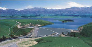 A recent announcement of $739,000 of Government funding for irrigation projects, including a ‘how to guide’ for the development of water user groups, has again placed the public spotlight on water resources and water allocation.
As proposals develop with Government support, Landcare Research researchers have been investigating the key social factors for getting new irrigation schemes underway and the important ingredients for effective governance.
Earlier this year the researchers interviewed people connected with five irrigation organisations in Canterbury and Otago; the Kakanui Water Allocation Committee, the Maniototo Irrigation Company, the Te Ngawai Water Users Group, the Opuha Water Partnership, and the Ashburton–Lyndhurst Irrigation Company. These groups were selected to reflect a range of ages, sizes, histories and origins.
Researchers interviewed farmer leaders in each group as well as liaison and regulatory staff in the Otago and Canterbury regional councils, and staff and office holders of third-party organisations that were required by consent condition or other legal arrangement to work with the irrigation organisations.
From these interviews a set of ‘factors’ emerged that are needed for the effective operation of these voluntary water sharing or communal irrigation schemes. These conditions seem to us to be important ingredients for the further development and effective operation of the self-management model in both regions.
The factors are:
- Community-based leadership
- Local identity
- Shared knowledge
- Reliable and up-to-date information
- Good relationships with regulators
1. Community-based leadership
Wisdom and judgement are essential in governance together with an ability to ‘take people along’ in a constructive and cooperative process. In all the cases studied, one individual or a small group of people have ‘put their hand up’ to take a decision or to guide or lead a group to a decision. Support is also needed from central or local government. The leader adds credibility to the group and this helps with engagement with the community and regulator.
2. Local identity
Where landowners/irrigators have a strong sense of place and identify with an area, its history and its land and rivers, governance arrangements and management decisions relating to that place and those resources are more likely to reflect the long-term needs of the community. Other users of the area, principally of the rivers, may also identify strongly with the area, laying the foundation for partnership around common goals. The arrival of new owners without local history and with different farming experience can threaten or destabilise both internal and external relationships, at least in the short term.
3. Shared knowledge
Stakeholders must have a good understanding of each others’ issues and concerns. This involves a shared knowledge of the different factors that bear upon a scheme such as land use (and misuse), water quality, ecology, and recreation. This aspect is the most visible and was common to the case studies, and includes recognition of the values of the local iwi.
Sharing of experiences is also an important trust-building factor and is time dependent. Eighteen months is reported in three case studies as the time span for meetings, information sharing and discussion to deliver marked benefits in compromise and concession between different interest groups.
4. Reliable and up-to-date information
Irrigators, regulators and stakeholders recognise the need for accurate information on water application and current and forecast water availability. Improving standards of measuring monitoring and reporting by all parties involved in water management and water use will lead to increased confidence in the data, and science, used to inform decision-making around water allocation and environmental flows.
5. Good relationships with regulators
A key challenge is establishing and maintaining empathy and trust between the individualistic and self-reliant farmers and the rule and regulation-focused regional council. The involvement of regional council field officers constructively bridges these divides.
Trust relationships are central to the effective operation of communal irrigation schemes. This was highlighted in many of the interviews and was a central theme regarding relationships between irrigation scheme members and their leaders, with external stakeholders, and with regulators.
Increased trust between those involved directly in irrigation schemes, and regulators and stakeholders, is increasingly recognised to shorten the consenting process and reduce the risk of litigation.
Further information:
Shona Russell
Biosecurity
Weed Identification Key
 Quickly and accurately identifying weeds has become a lot simpler with the launch of a new online weed identification key.
Developed by Landcare Research and other collaborators, the NPPA (National Pest Plant Accord) Key has been designed so that a user does not require extensive plant knowledge to identify weeds. The interactive key covers all 150 pest plant species currently banned from sale, propagation, and distribution within New Zealand, as well as more than 80 non-NPPA weeds and 60 other similar and related species. The key is illustrated with more than 5000 images.
“This new key will significantly benefit council staff and support their weed management strategies,” says Murray Dawson of Landcare Research, the lead developer.
“Until now, council staff have used the most authoritative publications – the New Zealand Flora series – to identify plants, but these have complex terminology and descriptions. And often using the traditional printed keys in these Floras you can only identify a plant based on its floral characteristics. This isn’t much help if you’re holding a leafy branch.”
The new key is multi-access, so you can start at any point. Users can identify plants based on 47 characters and 212 character-states, including leaf size and shape, floral and many other characters. Hyperlinks take users to more information at related websites such as MAF Biosecurity New Zealand, Ngā Tipu o Aotearoa – New Zealand Plants databases, and Weedbusters New Zealand.
Murray has run successful workshops to demonstrate the key. “Once you understand the basics, the key is very easy to use. People have been really enthusiastic about it – you can't get them off it!” Between now and March 2011 the key will be expanded to include all 328 species from the Department of Conservation’s (DOC) consolidated environmental weeds list, and it’s likely additional weeds will be added in future.
The development of the key has been funded by DOC’s Terrestrial and Freshwater Biodiversity Information System (TFBIS) Programme.
Further information:
Murray Dawson
Deadly kauri fungus continues to spread
 Landcare Research is striving to improve understanding of the kauri–killing fungus PTA (Phytophthora taxon Agathis), which was recently found infecting a kauri tree just 500 metres from Tane Mahuta.
This is the first time the pathogen has been confirmed in the world-renowned Waipoua Forest and puts the iconic kauri Tane Mahuta and other nearby giants at risk of being attacked by the pathogen. Previously, the nearest PTA had been found to Waipoua was at Trounson Kauri Park, one kilometre south of the Waipoua Forest boundary, where it had been recovered from the soil in 2005.
Landcare Research scientist Stan Bellgard believes that increased efforts are required to ensure Tane Mahuta does not fall victim to the pathogen.
Dr Bellgard and his team were guided into Waipoua Forest by Te Roroa kaumatua Davy Paniora and Stephen King of the Waipoua Forest Trust who were able to show scientists trees in the forest that exhibited classic PTA dieback symptoms. As well as finding PTA close to Tane Mahuta, the team found some other concerning discoveries.
Many of the infected trees discovered to date on Great Barrier Island and near Auckland have been rickers - young regenerating trees up to about 200 years old. However, at Trounson Kauri Park PTA was recovered from a 2m diameter large tree, at least 600 years old. Team member Dr Nick Waipara from the Auckland Regional Council said that they had discovered a similar-sized infected tree in a survey at the Cascades Park near Auckland. The fact that such large trees are becoming infected confirms the possibility that the iconic giants are at risk.
Symptoms of the disease caused by PTA include yellowing of foliage, canopy thinning, girdling of the lower branches and the eventual death of the tree. However, its most distinctive symptom is the excessive bleeding of gum from lesions in the bark near the base of the tree trunk Dr Bellgard says.
“We were shown some trees near Tane Mahuta with suspicious symptoms and detailed work has confirmed that one tree with characteristic 'pus-like gummosis' was infected with PTA. This is of particular concern because the tree is so close to Tane Mahuta.”
Landcare Research scientists have been working with colleagues in Scion, Plant & Food Research and the Auckland Regional Council to investigate the threat posed by PTA since it was discovered on the mainland in 2006. Dr Stan Bellgard says there is still a lot to find out about PTA.
“It is a bit of a sleeper. It was first recognised on Great Barrier Island in 1972 but was undoubtedly more widespread even then. While it is highly pathogenic to kauri, we know very little about how it spreads and infects trees in the wild. We suspect it is exotic, and are investigating it relationships with strains from overseas, especially South East Asia and Queensland.
Present evidence suggests PTA is a soil-borne disease with long-lived resistant spores that can spread by soil movement, and short-lived swimming spores that can be moved in water flow in soil as well as spreading tree to tree through close contact of the roots. Soil containing the long-lived spores is likely to be transported around on human footwear and by animals such as pigs.
Further information:
Stan Bellgard
Decision Support System for vertebrate pest control
 Recent knowledge about pest management and control has been incorporated into the new DSS.
Vertebrate pest control has become increasingly complex over the last 20 years, prompting Landcare Research to develop a web-based Decision Support System (DSS).
The new tool will improve the transfer of information from researchers to pest managers, to help ensure that the most appropriate control methods are rationally and transparently selected, says one of its designers, Dr Dave Morgan.
Local authorities currently spend about $45 million per year managing vertebrate pest populations, and there are complex considerations.
There is new knowledge of pest impacts and control, an increase in the range of products available for pest control, new legislative requirements for pest control agencies, increased public interest in the impacts and control of pests, diversification of the pest control ‘industry’, and reorganisation of the roles of some of the key participants.
In particular, local authorities have been faced with new responsibilities for pest management on private land under the Resource Management Act and the NZ Biodiversity Strategy. Very broadly, this requires local authorities to identify key biodiversity assets, and sustainably manage them.
As funds are always limited, principally by the number of ratepayers and rate levels, decisions have to be made about which biodiversity assets to manage and how to do this, and this usually involves pest control.
The logic of the new DSS, which is expected to be available by the end of the year, was designed by identifying the ‘generic’ questions that apply when pest managers are considering the most appropriate choice of control method, and using ‘yes/no’ responses to determine the decision paths followed. Such an approach is intuitively easy to understand and unambiguous.
The questions are focussed around the key issues of: operational aims, land tenure, farming practice, public and environmental safety, community views and involvement, and landowner views.
Consideration of these potential constraints in a logical and systematic way results in a series of recommended options being presented that are then further narrowed down by establishing what control methods may have been used previously (as frequent use of many methods results in declining effectiveness), and basing final recommendations on the basis of the likely cost of the remaining suggested methods.
All recommendations will be linked to best-practice advice which is based largely on Department of Conservation documents, and supplemented by practical guidelines for trapping pest animals published by the National Possum Control Agencies (NPCA). Best practice advice is, in most cases well supported by local research findings, for which references are given.
The system emulates the decision-making process that an experienced, well-informed pest manager would typically follow. However, the team stresses that the tool is designed to support, not replace, decision-making by pest managers. This is because there is always the possibility that the DSS may not consider every operational constraint that applies to a particular pest control operation in a particular locality.
While the development was initially driven by the needs of local authorities, the tool will be freely available, and it is likely to find use throughout the pest ‘sector’. It is expected that new information from research, field practice and manufacturers will be incorporated on an ongoing basis.
In summary, the DSS will:
- identify the most appropriate control options in response to proposed operational details and constraints;
- provide transparency/accountability in decision-making by producing a hard copy summary of the DSS input and output;
- enable prioritisation of pest control operations alongside other biodiversity ‘actions’ such as fencing or revegetation;
- provide for a consistent approach nationwide amongst pest managers considering all the key constraints when selecting pest control methods;
- present ‘best current practice’ for all control methods to maximise effectiveness and minimise risks.
This work was funded by an Envirolink ‘Tools’ grant from the Foundation for Research, Science and Technology. The Department of Conservation and NPCA are gratefully acknowledged for generously contributing information to this development.
Further information:
Dave Morgan
Land Environments
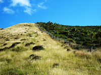
Land use change in the South Island tussock grasslands
The tussock grasslands in the South Island have typically provided broadsweeping and natural landscapes, both for recreationalists and low-intensity graziers. These landscapes have provided a wide range of ecosystem services to humans, from food and fibre, water regulation, natural habitat provision, through to recreation and tourism, and cultural services.
In recent years, this balance has been changing, due to intensification of agriculture. New irrigation schemes are offering the possibility of more intensive grazing on usually dryland soils, and the tenure review is promoting destocking of highlands in return for intensification of lowlands.
Ph.D. student Emily Weeks has been investigating land-use changes in the tussock grasslands. She has used satellite imagery to map changes between 1990 and 2008. The figure shows the changes to the 4 million hectares of tussock grasslands in the South Island. One million hectares of tussock grasslands has been converted to exotic pastures prior to 1990 (shown in yellow). Another 38,000 hectares was converted between 1990 and 2001 (shown in blue). A further 31,000 hectares was converted between 2001 and 2008.
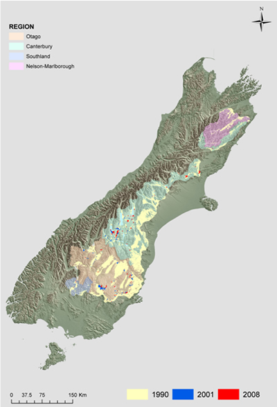
Intensification tends to take place in the lowlands first, so the proportion of these dry, lowland ecosystems left in a natural state is rapidly declining. Emily will now be investigating how agricultural intensification has affected biodiversity, both in the past and the future. She plans to investigate the drivers of land-use change and to model them into the future, and thereby the future impacts on biodiversity.
The results of her work will be used by the FRST-funded Ecosystem Services Program for Multiple Outcomes to help evaluate the conditions and trends of all the ecosystem services in the tussock grasslands.
Emily is located at Landcare Research, Palmerston North. She is supervised by Bruce Clarkson (Waikato University), and Susan Walker, John Dymond, and James Shepherd (all of Landcare Research).
Further information:
Emily Weeks
Considering Ecosystem Services in Policy & Planning
 Ecosystems are the result of a complex interplay among climate, water, soils, and species, including humans. Ecosystems perform the functions needed to support life on Earth, such as regulating climate, cycling nutrients, or purifying water.
Ecosystem services are defined as the direct benefits that humans derive from ecosystems. For example, fungi, worms, and bacteria process materials to create the fertile soils necessary to grow our food. The transformation of those materials is one service provided by ecosystems.
Taken together, the minerals, nutrients, organisms and their interactions represent “natural capital,” which is a natural analogue of the built capital such as our industries and factories that produce goods and services that we desire. Just like our built capital, we need to maintain and enhance our natural capital to insure an on-going flow of services that we need to maintain our quality of life.
More detailed studies of ecosystem services have only recently started. Landcare Research is undertaking an innovative new project to address the wise use of land and natural resources in New Zealand by considering all services provided by ecosystems in natural resource planning, policy and decision-making.
Currently, there are many regulations governing the use of natural resources including resource consents, regional/district plans, and national policies, says Dr John Dymond.
“They are all made at a variety of scales, administered by multiple agents, and often focus on a single issue or an ecosystem service. Furthermore, the information on which these decisions are made is sparse. This fragmented approach threatens New Zealand’s environmental integrity and trade.
“Our research will provide the data, knowledge, tools, and unifying concept to underpin a shift in natural resource management to move away from basing decisions entirely on maximising ‘provisioning’ ecosystem services, such as food and fibre, to consideration of a broader range of services critical to NZ’s overall well-being.
“Our team will produce a nationwide assessment of ecosystem services, determine how ecosystem services are linked to land use and management and offer a framework to adapt natural resource planning and policy across a broad range of outcomes.”
Dr Dymond says the work will be done in several ways including adapting respected international frameworks to local conditions and undertaking the first national scale attempt to comprehensively characterise current and future ecosystem services in New Zealand.
“We’re transforming a research concept into a policy instrument by assessing what types of information, data and tools are needed. We will also identify links with the co-management of resources under the Treaty of Waitangi, and consider Māori perspectives on holistic natural resource governance.”
Three inter-related research objectives aim to provide a holistic view of ecosystem service management:
Objective 1: developing methods to assess and map ecosystem services nationally.
Objective 2: developing methods to explore future changes in national land use patterns and implications for the composition and availability of ecosystem services
Objective 3: integrating multiple ecosystem services into planning and policy decisions and reporting protocols.
Further information:
John Dymond
Web: www.ecosystemservices.co.nz
Powerful new resource provides online access to important environmental data
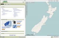 New Zealand has a powerful new online resource to assist people in understanding its diverse natural environments and resources.
With the launch of the Land Resource Information System (LRIS) Portal, individuals working in regional and central government, industry, research and education now have quick and easy access to environment data held by Landcare Research. These geospatial datasets, many of which are considered of national significance, can be used for creating maps, analysis, modelling and generally for finding out about New Zealand’s environments and land resources.
The information available includes records from the New Zealand land resource inventory, data underpinning the land environments NZ (LENZ) data set, fundamental soils layers, regional soil databases and digital elevation models. These data can be used in a diverse range of applications. Examples include catchment and resource management, national monitoring of carbon sources and sinks, studies of climate change, and preparation of farm plans for land managers.
Built using software provided by Koordinates Limited (http://koordinates.com), the LRIS Portal marks a major shift to free on-line access to geospatial information facilitated by Backbone funding from the Foundation for Science Research and Technology.
“Making data collected and managed by Landcare Research available to a wider audience through an easy to use facility is an important first step by Landcare Research to support New Zealand’s government-wide programme to open and reuse government data”, says David Medyckyj-Scott, LRIS Portal Project Leader.
Designed to make the data usable as well as accessible, each data layer comes with metadata (‘data about data’), supporting documents and easy to understand data use licenses. Users can select from a variety of data formats and, using a map-based interface, sub-set the geographic extent of the data so they only download data for the area they are interested. This means users no longer need to store large datasets themselves, they just take the bits they need when they need them.
The amount and type of data available in the portal will be added to significantly in the future.
“We have a list of data we have indentified that can be added to the portal in the coming months” says James Barringer, who manages the data in the portal.
“Many of these datasets haven’t been available publically before but we know they will be of considerable value”.
The portal itself represents the first phase of the development of Landcare Research’s spatial information infrastructure. It is also a key component in creating a new repository of authoritative New Zealand science datasets and information.
Further information:
David Medyckyj-Scott
Climate change
How are people responding to climate change in New Zealand?
 Landcare Research’s social research on climate change is informed by the idea that:
“As a social construction, climate change is no one thing. Instead it is an ensemble of constitutive processes, yielding an ever changing panoply of agents and institutions, fixed in place and meaning only for the moment” (Pettenger, 2007:7)1.
A Landcare Research team is looking at the various ways that individuals, the government, communities, and organisations in New Zealand are responding to discourses of climate change.
The team is examining published and online media, public opinion polls, policy and research documents, surveys of community organisations, findings from workshops and discussions, as well as interviews with key informants.
“To date we have identified media coverage of climate change fluxes in response to significant international and domestic policy events,” says researcher Alison Greenaway.
“Linked to this coverage were polls most commonly asserting the public were looking for government action on climate change. However debates over the form of action, who should take leadership, how responses are articulated and at what levels of government action should be occurring were fairly absent from most media coverage.
“Across all our data international policy forums (e.g. UNFCCC) were most commonly presented as the primary site for creating responses to climate change. On the domestic stage, central government policy has been framed around mitigating NZ’s unique greenhouse gas emissions profile with a much higher proportion of agricultural emissions (e.g., methane and nitrous oxide) measured than those generally seen within other country’s inventories. These policy responses were being made through existing policy networks with some new research arrangements supporting the policy development. These networks are primarily in the agricultural and energy sectors.
“There is also evidence of initiatives developing through research, agriculture, iwi, business and NGOs groups which are starting to link and network across sectors. However we found weak links between the civic climate movement (whose focus was on the international policy arena and consumer or household activities) and the domestic policy formation processes (primarily focused on agricultural and energy production strategies). The central linking point is currently the energy efficiency programmes run through EECA.
“Increased certainty around the Emissions Trading Scheme (ETS), through its passage into legislation has led to a steady and progressive interest in carbon business opportunities over the last 2 years mainly from farmers, foresters, owners of Maori land, and other land owners. There has been a steady increase in larger businesses and the electricity sector planning and attracting investment for alternative energy and domestic households adopting energy conservation strategies.
“Co-benefits with existing environmental priorities (often framed as “ecosystem services” or biodiversity) are being explored and prioritised through established local government and community agencies. We found some new groupings of people were emerging through these activities; these were primarily umbrella initiatives with established links to existing organisations.”
The team’s next phase of research will focus on how the framing of action on climate change is being shaped through intersecting policy priorities in specific locations. The team is proposing to track how discourses of climate change are enlisted through the water governance and spatial planning processes.
1 Pettenger M. 2007. The social construction of climate change: power, knowledge, norms discourses. Aldershot, UK, Ashgate Publishing Ltd.
Further information:
Alison Greenaway
Sustainable Development
Hatched – Sustainable Development Insights
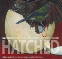 The findings and tools stemming from a decade of research into sustainable development have been presented in a comprehensive new e-book called Hatched.
Written for practitioners working in the business, government and community sectors, Hatched explores five key areas of capacity needed to chart a new trajectory for New Zealand’s long-term success: Thinking and acting for long term success; Businesses as sustainability innovators; Individuals as citizen consumers; Facing up to wicked problems; The future as a set of choices.
Hatched has been described as “one of the first true interdisciplinary case studies efficiently explaining and demonstrating the emergent properties of sustainability science” by Per G Berg, Professor in Landscape Planning, St Louis University. Closer to home, Viki Jane, the editor of NZ Management magazine described Hatched as “the basis for the conversations New Zealand needs to have.”
“Landcare Research has been looking at a whole range of ways that New Zealand can build capacity for sustainable development,” says one of the book’s co-editors, Bob Frame. “We thought it would be useful to bring those learnings together into one place, and an e-book makes the information very accessible.
“The issues addressed in Hatched are large and complex, and they won’t go away. These are issues that people in government and business are grappling with. It’s for New Zealand to find innovative responses to ensure our long term sustainability.”
Further information:
Bob Frame