Downscaling ecosystem services to catchment scale
A case study in the Ruamahanga catchment
The Ruamahanga catchment in the Wairarapa is important for productive, cultural, recreational and natural values. It comprises 350 000 hectares with mountains covered in native forest in the north-west, and a mosaic of pastoral farming and viticulture in the lowlands.
The water draining the mountains is of high quality, but somewhat compromised as it flows through grazing land in the hill country and Wairarapa lowlands, to the sea at Palliser Bay in the south. A community-based group, the Whaitua, is being set up to establish water quality and quantity limits for the catchment. In setting these limits, the Whaitua will have to take into account competing demands for land. There is also a proposal to build large storage dams to enhance summer water supply over much of the lowlands.
An ecosystem services framework can help depict a broad picture of impacts of land use or land management in the catchment. National models already exist for certain ecosystem services: provision of food, timber and wool; fresh water natural habitat; regulation of climate; soil erosion and water flow. However, when local issues are being addressed, downscaling to local detail becomes important. We used detailed soil maps to produce maps of overland flow and drainage. From these, we were able to produce catchment-wide maps of pathogen sources (E. coli) connected to streams (Figure 1). These maps provide useful context to those setting water quality limits for the Ruamahanga catchment.
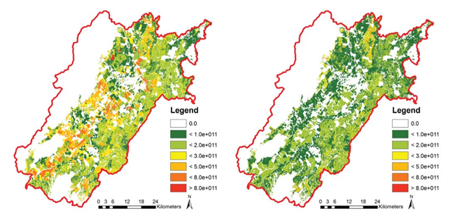 |
| Figure 1. E. coli sources in Ruamahanga catchment. Left: current baseline; Right: with fencing everywhere. |
We have also produced detailed maps of floral resources for assessing pollination services. We used Landcover Database version 3 and visually interpreted satellite information (SPOT) to improve the land cover classes (mānuka, gorse, riparian vegetation). Each land cover class was characterised, using expert knowledge, with estimates of nectar production and flowering time. We then designed a spatial model to combine floral resources with nectar requirement for sustaining hives and bee flying distances to produce a map of hive-carrying capacity (Figure 2).
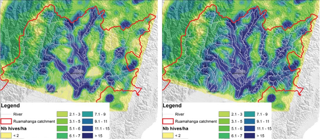 |
| Figure 2. Hive carrying capacity (hives per hectare). Left: current baseline; Right: with fencing everywhere. |
The ecosystem services approach permits the assessment of catchment-wide mitigation strategies. For example, preventing direct stream access by cattle through fencing could reduce total E. coli sources by about 35%. Furthermore, fencing in combination with riparian management could provide additional floral resources that honey bees can feed on, and hence increase the capacity of the landscape to sustain hives.
Other scenarios are being developed, including wetland enhancement, soil conservation in the hill country, and implementation of best management practices for farm and municipal effluent. We are also investigating limits and trade-offs in managing agricultural intensification using potential irrigation schemes as the basis. We use multi-objective spatial optimisation to integrate economic, social, and environmental criteria to assess the potential effects of different on-farm management practices and spatial land-use confi urations (i.e. irrigable areas) on soil natural capital and the provision of catchment-wide ecosystem services and economic returns.
Our work aims to help decision makers by using ecosystem services as a framework for thinking about trade-offs and co-benefits of mitigation options in a catchment context.
John Dymond, Anne-Gaëlle Ausseil & Alexander Herzig — Landcare Research