Method and framework

Method and framework
The present research, which made use of participatory methods involving a number of Māori organizations and individuals in New Zealand, established a number of culturally acceptable methods for recording, organizing and making available information on Māori values in a textual and computerized form (Harmsworth 1995, 1997b). All such information was classified according to specific geographic tribal areas (ranging in size from 500 km 2 to 5000 km 2 ). This produced models linking traditional knowledge -- often in both oral and textual form -- to GIS and multi-media systems. These models made it possible to store information on Māori values (see table 1) and biophysical information, for the benefit of environmental management planning, while protecting confidentiality and addressing intellectual property rights. Before making use of GIS technology, all information was recorded and organized within a framework (see table 2).
| Type of information | Examples |
| Historic places, and tribal landmarks | Fortified villages, hills, rocks, rivers |
| Cultural and social sites | Sites such as "marae" which exist today |
| Ancestral sites | Traditional land tenure, historic tracks |
| Archaeological sites | Cooking sites, tools, weapons, artefacts |
| Sacred sites | Historic burial sites, sacred battle grounds |
| Indigenous place names | Correcting the spelling and adding placenames to maps, recording knowledge/ histories about indigenous placenames |
| Biophysical resources | Landforms, soils, flora and fauna, water quality, geothermal and coastal resources |
| Special plants, special types of trees | Plants used for weaving, wood for carving, traditional medicines |
Table 1. Recorded information on Māori values
A framework for enhancing the use of indigenous knowledge is discussed in Mathias (1995). In the present study, information pertaining to each geographic area was organized and arranged within the framework shown in table 2.
On the y-axis the information was classified according to eight main groups, although certain information may appear in more than one group. In general, the lower the number, the more sensitive the information (1-8). On the x-axis information is arranged according to its confidentiality and detail, and is designated as national, regional, local/community, and individual levels. Along the x-axis, from left to right, the information becomes increasingly more detailed, confidential and personal; greater importance is placed on property rights; and access to information becomes restricted. The location within the framework indicates the type and special attributes of the knowledge, and determines whether the information may be transferred to more general levels for use by outside agencies.
| Main groups used in Māori values classification | a. National level, central government (national databases public domain access) |
b. Regional and district databases, such as local government
(conditions and criteria required for storing confidential information) |
c. Māori databases such as at the iwi or hapuu tribal level
(secured protection of information) |
d. Individual or group information - extended family (whaanau) or individual
(highly sensitive or personal infomation) |
| 1. vegetation | 1a. national or regional data on vegetation and land use | 1b. regional or district data on vegetation and land use | 1c. local information on vegetation types | 1d. plant uses, plant varieties, medicinal plants, plants for weaving etc. |
| 2. animals, birds, fish, insects | 2a. national or regional data on animals, birds, etc. | 2b. regional or district data on animals, birds, fish, insects | 2c. local information on animals, birds, fish, insects | 2d. special animals, birds, fish, insects, such as special foods, cultural harvest, fishing grounds etc. |
| 3. land, soil | 3a. national or regional data on landforms, soils, etc. | 3b. regional or district data on landforms, soils etc. | 3c. tribal information on land features, landforms, soils, etc. | 3d. special landmarks, land features, traditional knowledge on soils and cultivation, muds/dyes for weaving etc. |
| 4. water | 4a. national or regional data on water | 4b. regional or district data on water | 4c. tribal information on water | 4d. detailed or confidential information on water |
| 5. air | 5a. national or regional data on air | 5b. regional or district data on air | 5c. tribal information on air | 5d. detailed or confidential information on air |
| 6. special places | 6a. limited information on special places, cultural sites | 6b. regional and district information on special places, cultural and historic sites | 6c. tribal information on special places, cultural and historic sites (such as archaeological sites) | 6d. detailed or confidential information on special places, cultural and historic sites |
| 7. sacred sites | 7a. little or no information at the national or regional level | 7b. regional and district information on some sacred sites (generalised information) | 7c. tribal information on sacred sites (such as burial grounds) | 7d. detailed or confidential information on sacred sites (such as burial grounds) |
| 8. metaphysical | 8a. little or no information at the national level | 8b. no information at the regional or district level | 8c. tribal information on metaphysical information (spiritual, cosmological) | 8d. detailed or confidential metaphysical information (such as spiritual, cosmological) |
Table 2. A matrix framework for recording information on Māori values
Suitable GIS database structures have been designed to accomodate the setup described above. Once information is stored, links are provided between information at the national level and information accessible at the local or community level; the latter is likely to be detailed and confidential, requiring some form of restricted or protected access. Each piece of information recorded is referenced to an original source or sources, such as a person, book, archive or map, and all references are appropriately coded for database entry.
Once information is classified and stored in the framework it can be spatially represented in the form of layers (see figure 4). Each layer is characterized by different levels of detail, sensitivity and confidentiality, which together determine the degree of access at each level.
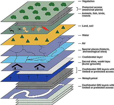 |
Figure 4: GIS layers and confidential sub-layers. |
Knowledge directories
Information too sensitive or confidential to store in a GIS is linked via a database directory to an individual person. This allows additional information to be obtained from an alternative knowledge source. Some of the available options are shown in table 3.
| Type of information | Examples |
| (1) Silent or concealed files | Recording the information in an archive or filing sytstem, linked to a GIS database or a map. |
|
(2) Overlay or grid to flag sensitive areas |
Recording the information for example as a grid network, which does not identify the actual position or location of confidential or sensitive information such as sacred sites. |
|
(3) Link to books maps, etc. |
Setting up a directory to direct the enquirer to associated knowledge in books and maps. |
|
(4) Link to people such as Māori elders |
Setting up a directory to direct an enquirer, via a Māori organisation or contact, to an individual for answers to particular questions and associated traditional knowledge. |
Table 3. Example of options for a knowledge directory
By following the options in table 3, highly sensitive or confidential information can be displayed in the form of a label on a map, alternatively, it can be simply flagged in the GIS as a sensitive or restricted area and the enquirer directed to another information source. This latter option relies on the availability of people with accurate traditional knowledge. Sadly, traditional indigenous knowledge is diminishing at an alarming rate as the population ages (Maundu 1995).
Discussion
Although the methods described above are still in the experimental stage, they provide insight into what is required in order to develop culturally appropriate GIS tools. In an increasingly knowledge-based and technologically advanced world, they underline the need to take into account intellectual property rights, sensitivity, confidentiality, and links to other non-computerized knowledge-based systems. A great deal of traditional indigenous knowledge has already been irretreivably lost in New Zealand, and with the ageing of those in the indigenous population with strong links to the past, we are rapidly running out of time. Society must make clear what value it places on this information from a traditional or indigenous source.
There is enormous potential for the use of indigenous knowledge to enhance our understanding of the environment, underpin culturally appropriate development opportunities, and provide a more holistic and integrated perspective for planning and policy in the twenty-first century.
I hope that GIS and the methods sketched here will be of some use in furthering those aims.