Catchments extend offshore
Case Study 2
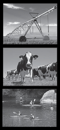
All New Zealand catchments drain to the coast. ICM research showed that the Motueka ‘catchment’ effectively extends offshore, affecting more than 400 km2 of the marine environment of Tasman Bay. Physical and chemical (nutrient) characteristics of the water column within the river plume stimulate the growth of micro-algae on which shellfish (including farmed mussels) depend for food.
Suspended sediment flushed from the upper catchment interferes with the feeding of scallops and potentially other filter-feeding seabed species. Suspended sediment on the seafloor looks like a major contributor to the poor performance of the Tasman Bay scallop resource in recent years.
Of the 400 km2 of catchment influence, about 180 km2 of seabed has a terrestrial signature from the river outwelling plume. Naturally high heavy metal levels (Ni, Cr, Cu) within the sediment flushed from the Red Hills at the head of the catchment (see sediment research) may be affecting marine and freshwater life because they are beyond ANZECC threshold levels for biological effects.
In addition, water quality and productivity in the 4200 ha of designated Aquaculture Management Areas off the Motueka river mouth is affected by the river discharge, particularly during large floods. The extent and magnitude of freshwater effects on seawater temperature, salinity, density, phytoplankton growth and decline (chlorophyll-a), water clarity and nutrients has been mapped to provide a basis for understanding the nature and spatial extent of catchment effects on aquaculture.
Information generated through the ICM Programme has proved critical to consenting of a large offshore mussel farm in western Tasman Bay. High mussel growth rates occurred during spring and autumn 2008/09 with a slowdown during summer, consistent with what researchers predicted for the river plume. Mussel growing conditions and catchment implications are being tracked over time using measured nutrient loads and long-term data from the ICM buoy 6 km off the river mouth.
Harvest criteria are presently being developed by the mussel industry using ICM data of mapped faecal indicator organisms after heavy rain within the river plume. Cawthron’s new microbial source tracking (MST) technology showed that faecal contamination in mussels 7 km offshore came from cows - the first observation in New Zealand of ruminant faecal contamination from a river plume extending offshore. The management applications of the ICM river plume monitoring buoy have strengthened over time with the trialling of new and more robust components. Seasonal and flood-related events shed light on the variability of food for mussel and scallop growth and can now be linked directly to aquaculture responses. Nutrient loading from the catchment to Tasman Bay varies seasonally and between years, with resulting ecosystem implications.
Data collected on catchment discharge impacts in the bay have been applied in models of hydrodynamics (currents and tides), water quality distribution across the bay and with depth, phytoplankton growth and decline, and the marine foodweb from algae up to finfish. These models allow evaluation of trade-offs between large-scale land use change onshore and aquaculture scenarios offshore (see integrated modelling). These connections discovered from the ICM project demonstrate that management of coastal ecosystems, fish and shellfish resources needs to take account of activities across the entire mountains-to-sea continuum comprising our redefined ‘catchment’. This is a major deviation from current coastal management practice.
Paul Gillespie
Contact: Cawthron Institute, Nelson
paul.gillespie@cawthron.org.nz
Chris Cornelisen
Cawthron Institute, Nelson
Chris.Cornelisen@cawthron.org.nz