Silent movement from mountains to sea
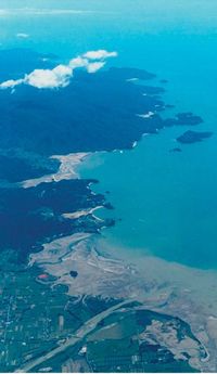
Image - Paul Gillespie
Case study 6
Despite relatively low sediment yields by New Zealand standards, land management for fine sediment control and river gravel extraction have both been contentious issues in the Motueka catchment. Landowners are often blamed for inadequate precautions when big storms hit, yet how much management is enough? Riverbed levels are naturally declining but how much is this exacerbated by gravel extraction?
ICM research addressed both questions. One benefit of running a 10 year study is that a major storm is likely to occur during the research period. A localised ‘1 in a 100 year’ storm that hit the upper Motueka and Motupiko catchments in March 2005 dumped about 170 mm of rain in 4 hours. Heavy metals in fi ne sediment from the Red Hills mineral belt in the headwaters were tracked 100 km downstream and out into Tasman Bay, and the effects are still dissipating. Marine sediments collected from a network of 24 stations in western Tasman Bay showed that the influence of the river plume extended out to around 7 km offshore from the river mouth, with a detectable sedimentation footprint covering an area of about 80 km2 and with plume-affected nickel concentrations up to 7 times higher than background levels in other regions of the bay.
Storm sediment yields increased by a factor of 20 in the headwaters. If we apply the pre-March 2005 peak flow – storm sediment yield relationship to the flow record then sediment yield is estimated at 94 t km-2 y-1. If however we incorporate the effects of this large storm, sediment yield is estimated at 519 t km-2y-1. This revealed the importance of long-term data – over decades – to establish accurate estimates of sediment yield, such as might be required to estimate reservoir sedimentation.
We also developed a Fine Sediment Abundance (FSA) method to rapidly monitor changes in the amount of fi ne sediment on a riverbed. This has already proven useful for regional councils’ State of the Environment monitoring and to complement instream biological surveys. The FSA method showed substantial changes in the proportion of fines in the riverbed after the March 2005 flood, indicating it was able to detect changes effectively in the percentage of fines.
Gravel is the larger fraction of sediment moving from mountains to sea. Regional councils routinely use surveys of river cross-sections to estimate how much gravel can be allocated for extraction. However, our research showed that cross section surveys typically only give a minimum estimate of the gravel transport rate. Annual GPS surveys in the upper Motueka showed that the cross-sections underestimated the changes in gravel volumes stored in the riverbed by about a factor of 3, but did confirm the overall decline in riverbed levels. This information has been useful in supporting reviews of regional councils’ river gravel monitoring and resulting gravel monitoring allocation plans.
Les Basher