Issue 3, September 2011
In this issue:
|
|
Editorial
Kia ora tatou
Over the next four years we’ll be working closely with the Ministry for the Environment on an exciting new mapping project to better understand our changing land environment.
The significance of the third and fourth phases of the Land Cover Database (LCDB) Programme, featured in this edition, was apparent in the comments by the Environment and Science Ministers at the recent announcement.
“(The programme) will provide vital information about our rural and urban environment for the natural resources sector, regional councils and research organisations to use,” said Environment Minister, Dr Smith. “Using the best in modern technology, we can thoroughly map New Zealand’s changing land use so we can quantify the pressures on water quality and biodiversity.”
Science Minister Dr Mapp said land cover research is moving forward and needs to apply the best in science and innovation for the sake of New Zealand’s environmental and economic health.
“Up-to-date information about vegetation, water sources and the built environment is critical for the success of natural resource industries such as agriculture and forestry,” Dr Mapp said.
In future editions we will look at other initiatives and opportunities to improve national datasets and data layers to help improve the performance of industries as well as support meaningful environmental reporting of state and trend.
But for now, we highlight work on ‘the WaterWheel’ an innovative new tool for catchment water management; provide a wrap-up of the Life Cycle Management (LCM) programme; and mention the release of the first of three biocontrol agents that should have a significant impact on the troublesome weed, tradescantia.
Finally, if you are Wellington-based, I hope you can make it to the first of our ‘Landcare Research Link’ series of short seminars and discussions for environmental policy-makers and practitioners. The first seminar is on ‘Estimating the Impacts of a Multi-Policy Initiative at the Catchment Level’, on Tuesday 27 September.
I hope you find this newsletter interesting. As always, I would welcome any feedback.
Best wishes,
Alison Collins
Acting GM Environment & Society
Land-water environments
New databases to highlight land cover change
 How and where is land cover in New Zealand changing through time? What are the major characteristics of this change? These two key questions that will be answered by new editions of the New Zealand Land Cover Database (LCDB).
LCDB is a digital map of the surface of New Zealand created using satellite imagery. It contains detailed information on categories of land cover and boundaries, and is a record of land cover changes over time.
Two completed editions (LCDB1 and LCDB2), which show the state of New Zealand’s land cover in 1996-1997 and 2000-2001 respectively, have become critical to central, regional and local government, industry and research institutions. The information is used for land, water and biodiversity management, pest control and monitoring, wildfire threat and risk analysis, and environmental monitoring and reporting.
The creation of new land cover databases and related research has been identified as an important priority by Ministry for the Environment (MfE), Department of Conservation (DOC) and regional councils.
Landcare Research has been commissioned to deliver two further editions of LCDB and, a parallel research programme that will develop improved ways of generating land cover information.
The two new editions will leverage off the significant investment by MfE in research and imagery for their Land Use & Carbon Analysis System (LUCAS) programme. LCDB3 will be derived from the 2008 LUCAS satellite imagery and delivered in July 2012, while LCDB4 will use 2012 LUCAS imagery and will be delivered in July 2014.
“This project will answer key environmental research questions about how land cover is changing,” says Project Leader, Peter Newsome. “The research will also answer a number of other fundamental research questions about land cover classification.
“This research has spin-off benefits for other applications that require spatial analysis and classification of imagery – ranging from the monitoring of sustainable land use, habitat analysis, agricultural applications, economic modelling, to disaster response planning.
“Our goal is that by 2015 end-users will have access to a well established series of LCDB editions that provide the authoritative record of land cover and land cover change in New Zealand. These datasets will be widely used to support decisions on land utilisation, along with monitoring and reporting requirements.
“Landcare Research will also have an effective methodology and the experience and user support to take the series into the future as a leading edge land cover classification utilising the most appropriate satellite imagery available at the time.”
Peter says the project is collaborative, involving MfE, DoC, MAF and regional councils. “They will actively participate, contributing data and participating in specific activities, such as field verification.”
Governance and wider stakeholder advisory groups will be formed to guide future development of the LCDB and the research priorities required to deliver it.
The development of LCDB3 and LCDB4 is largely being funded by MSI and MfE, with support from DOC, MAF and regional councils.
Further information:
Peter Newsome
Innovative tools for water management
 An innovative new tool – the WaterWheel – will be an important component in a new project recently funded by the Ministry of Science and Innovation. The Waterwheel project is a partnership between Aqualinc, Landcare Research, AgResearch and Tipa Associates which aims to capitalise on the power of collaborative approaches for managing water allocation and protecting water quality.
Regional and unitary councils are increasingly setting limits on river flows, bulk water allocation and water quality at the scales of catchment, sub-catchment and water management zone. The Waterwheel project examines how to set and implement such limits collaboratively with water users and stakeholders, and how to sheet home the responsibility to individual water and land users, while achieving acceptable cultural, economic and social outcomes.
The WaterWheel itself is a single, visual representation of the ‘health’ of a catchment or water management zone with each spoke of the wheel representing an indicator of environmental, social, cultural or economic variables. The idea is a visual tool which can be used by water users at a sub catchment level, community groups at a catchment scale, industry bodies such as energy companies, and agribusiness and policy agents at the catchment, region and national scale.
Landcare Research scientist Andrew Fenemor says at present there is no real means for water users at a sub catchment scale to understand, and therefore actively manage, the impacts of their decisions on both flow and quality states.
“The cumulative impact of many users requires both individual and collective responsibility for actions. At present there are few examples of collective institutions in place at nested scales to deliver agreed catchment outcomes. Most decisions around water use will still be taken to optimise an economic output with little understanding of the flow-on consequences of these actions for environmental as well as social and cultural outcomes,” he says.
This programme aligns with Land and Water Forum recommendations, SWIM and MfE targets, and addresses Ground Water Forum critical issues by designing improved institutional arrangements. It fills a research gap by developing a tool and process for setting limits which balance the values of communities, and improve water use and quality at a variety of scales.
The programme was developed through an equally innovative initiative, the ‘Freshwater Sandpit’ research planning process last March and imported from Europe. The ‘sandpit’ was an intensive, week-long brainstorming session to develop creative research projects.
As the proposal notes “The distinguishing feature of this research is that we are aligning and integrating institutional behaviour to our understanding of the physical dynamics of water movement through the medium of a tool and process that will allow feedback between collective actions and the meeting of environmental, social, cultural and economic states.” Matauranga Maori is integral to the institutional design and the development of the tool. The research will be informed by literature, analysis of existing case studies and workshops, and a proof of concept will be tested in two sub catchments (yet to be determined).
The outputs will be unique and innovative because they are the product of an interdisciplinary research approach integrating social science with economics, political governance, collective learning and environmental science. A new collaborative governance design will be developed to manage water and land to meet acceptable standards in line with environmental, social, economic values.”
The Waterwheel research team includes John Bright (Aqualinc), Andrew Fenemor (Landcare Research), Liz Wedderburn (AgResearch) and Gail Tipa, plus international input from scientists from Europe who attended the Sandpit. The programme builds on research completed in integrated catchment management (ICM), the Pastoral 21 environment programme and various regional council catchment projects.
As Andrew Fenemor notes “We’d like to get to the point where catchment landowners think about doing their Waterwheel accounts when they do their GST reconciliations every 1-2 months”.
Further information:
Andrew Fenemor
Soil conservation reduces sediment yield in rivers
Many rivers in the Manawatu-Wanganui region are silt-laden because of hill-country erosion. Sediment is deposited on river channels, reducing flood capacity and spoiling aquatic habitat. Sediment is also a major source and carrier of phosphorus that degrades water quality. The Horizons Regional Council are encouraging soil conservation through the Sustainable Land Use Inititiative (SLUI). Farm plans are being developed for farms on highly erodible land and farmers are subsidised for erosion control works, such as forestry, retirements, and soil-conservation tree planting. SLUI will spend up to $80 million in the Manawatu-Wanganui region.
To help plan and assess progress in SLUI, John Dymond (Palmerston North), Daniel Rutledge (Hamilton) and Suzie Greenhalgh (Auckland) of the Ecosystem Services Program for Multiple Outcomes are providing a model for assessing the impacts of farm plans on sediment yield. The model integrates the soil-conservation effects of farm plans over water management zones throughout the region. Sediment yields are estimated for present day, for 2020, and for target (i.e. all farm plans implemented and fully mature). Results showed that many of the silt-laden rivers have a target reduction of about 50% in sediment yield, such as the Turakina, Middle Whanganui, Lower and Middle Whangaehu, Akitio, and Owhanga. By 2020, about half of the target reduction would have been realised.
The water management zones of the Manawatu River generally have lower targets of about 25% reduction, with the exception of the Tiraumea tributary that has a target of about 50%. These data are being used by the Integrated Freshwater Solutions program (MSI funded) in their mediation of stakeholders in the Manawatu river accord. In future, the model will be further improved using more comprehensive measurements of erosion and sediment transport in the Clean Water Productive Land research program (MSI funded).
Further information:
John Dymond
Development of a new erosion model for New Zealand: SedNetNZ
 To be useful to land managers erosion models need to be able to provide information on spatial patterns of sediment sources, contributing processes (e.g. landslides, gully, bank erosion), and land use influences on erosion. This would allow better targeting of erosion mitigation measures and assessment of their success on-site and off-site. Both empirical (e.g. NZeem®, SPARROW) and dynamic simulation models (e.g. WEPP, SWAT, SHETRAN) have recently been used in New Zealand. Empirical models have limitations such as lack of process representation, while dynamic models are very difficult to parameterise and apply at large spatial scales and typically don’t simulate mass movement erosion.
As part of the Ministry of Science and Innovation-funded programme ‘Clean water, productive land’, Landcare Research is developing a new erosion model based on the Australian sediment budget for river networks model (SedNet). This approach provides a middle ground between lumped empirical models and dynamic simulation models. The impetus for this development is to provide a model with better erosion process representation, explicit linkage between hillslopes and channels, and simulation of catchment-scale connectivity in order to be better able to simulate the effects of land management changes on upstream sediment loading and downstream response.
The basic element in the model will be the stream link. Each link has an internal catchment area (watershed) which drains overland flow and delivers sediment to that link. For each link an annual mass budget and sediment yield is calculated by taking the difference between: (1) the sum of sediment supplied from the internal catchment area and upstream tributaries; and (2) the loss of sediment in the channel, on floodplains and in any reservoirs and lakes. Sediment supply is the sum of sediment delivered from hillslope (landslide, earthflow, surface wash), gully and riverbank erosion processes. The main outputs from the model will be predictions of mean annual bed and suspended sediment loads in each stream link, throughout the river network. Because source erosion will be spatially linked to sediment loads, it will be possible to examine the proportionate contribution that specific areas of land make to downstream export of sediment. By adjusting input data and model parameters it will be possible to simulate river loads for natural conditions (pre-European) and examine the consequences of future land use or climate change scenarios.
The model is being developed using the Manawatu River as a case study and utilising the extensive set of suspended sediment data currently being collected by Horizons Regional Council. The Manawatu also provides the opportunity to demonstrate the effect of land management change, being implemented as part of SLUI, on sediment generation and transport. Ultimately we aim to incorporate SedNetNZ into the CLUES modelling framework to replace the current sediment model (SPARROW).
Further information:
Chris Phillips
Les Basher
Climate change responses
Igniting social knowledge about climate change
 Climate change and sustainability need to be ‘re-framed and re-imagined’ as locally understood and relevant issues before most New Zealanders will embrace low-carbon lifestyles, according to a leading group of social scientists.
A new report,
‘Degrees of Possibility: Igniting Social Knowledge around Climate Change’, says climate change has been framed as a singular, global and temporally distant problem, removed from people’s immediate concerns and everyday lives.
Landcare Research social scientist, Alison Greenaway, one of the report authors, says that in replacing the doomsday discourse of climate change with an imaginative and aspirational one we need a uniquely New Zealand perspective.
“Climate change needs to be connected to our sense of identity. We need to understand what a changing climate will mean for our lifestyles and cultures, what we value, for our agricultural and biological economies, and we need to collectively find our own ways to adapt.”
Alison teamed up with counterparts, Brendon Doody of GNS Science and Karen Cronin of ESR, together with the New Zealand Climate Change Centre to produce the ‘Degrees of Possibility’ report.
“The report presents a unique New Zealand take on the current state of social knowledge around climate change, highlights key questions that need to be addressed and potential processes for future engagement and interdisciplinary collaboration.”
The report followed a December 2010 workshop with the same title, attended by 110 people. The aim of the workshop was to facilitate dialogue within the social science community, and between social scientists and biophysical scientists, around climate change.
“We believe there are four important ways that social science is contributing to dialogue about climate change,” says Alison.
- Improving social understanding of climates and the relationship between climate and societies;
- Providing new perspectives and potential breakthroughs in the debates around climate change, and supporting cohesive social discussion and constructive policy development;
- Applying and developing social science knowledge and tools to create new insights and pathways for institutional transformation, organisational learning and social change;
- Providing evidence to support decision makers in institutions and organisations.
The report recommends three key research themes to be considered in the development of a New Zealand social science research agenda for climate change:
- General framework for enquiry: How are we making sense and responding to the phenomena of global change, including human-induced climate change?
- Changing practices in everyday life: How well do we understand the specificities of resource-intense everyday practices in New Zealand? How can resilience and adaptation be introduced without undermining our commitments to quality of life and social cohesion?
- Enhancing institutional capacity: How can we enhance organisational capacities for understanding and addressing climate-related practices across organisations and sectors?
Alison, Brendan and Karen are now developing their next phase of work with the Royal Society of NZ, UNESCO, the NZCCC, BRCSS and He Waka Tangata to address these suggestions and further support the production of social knowledge around climate change.
Further information:
Alison Greenaway
Sustainable business and communities
Valuable Benefits from Life Cycle Management Programme
 Improved market access and reduced costs were two of the key advantages for New Zealand businesses that took part in a recent Life Cycle Management (LCM) programme.
LCM helps organisations to minimise the environmental and economic impacts of products and services, and provides a focus for reducing their environmental impacts beyond the factory floor.
Six manufacturing companies took part in the programme, which was led by Landcare Research and funded by Ministry for the Environment and Ministry of Economic Development, and supported by BusinessNZ and New Zealand Trade and Enterprise.
Programme Leader Anthony Hume says LCM is a relatively new approach in New Zealand. “It provides an integrated framework to boost environmental performance of products by reducing impacts in the supply chain, manufacturing processes and distribution, as well as disposal of products,” says Anthony.
The project enabled each firm to develop a LCM product strategy, engage in the Enviro-Mark environmental management programme, and complete a product life cycle study to quantify the environmental impact of a product. In depth training was provided for addressing environmental impacts in product design, production efficiencies, marketing and understanding customer needs on environmental issues. LCM experts from Landcare Research were also on hand to provide support to the companies when needed.”
Anthony says several companies gained significant benefits from participation in the project including:
- Access to new markets through demonstrating environmental credentials of products
- Product redesign to reduce impacts in distribution and lower energy use
- Improved resource efficiency and reduced waste costs
- Assessment of options to reduce carbon emissions throughout the supply chain
- Information for customers on product environmental performance
- Environmental criteria added to product development information
Research in the project identified a number of key success factors and barriers to LCM adoption.
“Establishing a strong medium and long-term business case aligned to company goals and gaining commitment from senior management in delivering a comprehensive change management process are critical to LCM adoption,” says Anthony.
“Barriers to the development of a strong business case were the availability of systematic environmental data and the lack of analysis of market issues relating to environmental issues. Other barriers to implementation included difficulties in involving staff across each organisation in initiatives to reduce impacts and constraints in influencing larger or geography distant operators in the supply chain. Companies are also not confident in communicating the results of activities to reduce environmental impacts.”
Anthony says that building LCM initiatives within industry in the future need to focus on:
- Greater everyday involvement of the CEO/senior managers in the set up of LCM activities
- Flexible and tailored delivery frameworks for training firms
- Increasing the understanding of importance of change management in meeting customer environmental expectations
- Improving the selection of firms that would benefit from LCM
“Companies facing product environmental challenges would also benefit from a better understanding of the policy measures that facilitate the uptake of LCM.”
Landcare Research is now reviewing opportunities to amplify the research with businesses and industry groups.
Further information:
Christine Harper
Water footprinting the kiwifruit supply chain
 Freshwater consumption in the growth of food products is fast emerging as a major issue for global retailers and businesses, such as Unilever, in a similar fashion to carbon footprinting. Water footprints are intended to improve consumer understanding of freshwater consumption by products and potentially heighten awareness of options for reducing freshwater consumption within global supply chains. For example, agricultural activity is estimated to constitute on average 80% of the water footprint of food products. It is becoming abundantly clear that, unless businesses begin to address issues such as reducing competition for scarce water resources, they will face major challenges in securing enough water to underpin economic growth and meet environmental requirements.
MAF and Zespri International commissioned Anthony Hume and Carla Coelho (both Wellington) to assess the water footprint of green kiwifruit supplied to the UK — the environmental impact of water used, directly and indirectly, throughout all stages from growing the fruit through to it reaching the consumer. The recently completed project, a partnership with Plant & Food Research and AgriLink, was the first-ever comprehensive water footprinting exercise to be carried out in the New Zealand horticulture sector.
Anthony and Carla evaluated two emerging approaches - the Water Footprinting Network (WFN) and Life Cycle Assessment LCA), and also investigated a third hydrological-based perspective. Used in tandem, these different approaches provide deeper insight into the direct and indirect freshwater consumption by a product. Applying the volumetric WFN methodology on the orchard showed that, based on the national average, the majority of water consumed in the cultivation of green kiwifruit (85%) is taken from rainwater or soil moisture. Five percent of water consumed was taken from irrigation and 10% is the volume of water needed to dilute orchard inputs below safe drinking standards e.g. nitrogen fertiliser entering the environment. At the orchard gate green kiwifruit has an average water footprint of 417 litres per kg of fruit.
The LCA work highlighted regional differences in potential environmental impacts from the freshwater used in cultivation - several regions made a relatively low contribution to national production yet had relatively high environmental impacts. For example, the contribution of the Auckland region to environmental impacts of freshwater consumption is given greater importance using the LCA environmental impact indicators than the WFN method. One possible explanation could be that areas with a high population density tend to place higher stress on water resources because of higher urban use rates and can fare worse than other areas; the LCA method takes into account basic socio-economic factors that lead to domestic, industrial and agricultural water use.
The hydrological perspective included run-off and drainage flows not taken into account in either the WFN and LCA footprint methods but usually included in water balance assessment, and was developed as part of research looking at reducing water use. The first scenario was to convert all irrigated kiwifruit orchards in all regions to rain-fed orchards. At the regional scale, converting irrigated orchards into rain-fed orchards had a significant impact on water footprints for only the low rainfall areas (Hawke’s Bay, Gisborne and Nelson). However, this significantly reduced orchard gate returns for Hawke’s Bay and Nelson. In principle, this is a feasible option only for Gisborne. Several other options associated with the use of N fertilizer in the Te Puke region were examined. Neither the application of fast-release nitrogen fertiliser nor halving of the amount of nitrogen fertiliser typically applied had a significant influence on the water footprint.
Water footprinting methods are developing very quickly as more company and sector case studies are published. Although the project highlighted a number of important data gaps requiring further investigation throughout the supply chain, the research has been of considerable value to Zespri. They will use results to support positive positioning with key global retailers, such as Walmart, Marks & Spencer and Sainsburys, that are increasingly paying attention to water footprints of suppliers.
Other water footprinting projects are underway currently for the red meat and merino sectors, with several different methods being developed in parallel. MAF will use the results to understand the differences between the different methods advocated, and to formulate New Zealand’s responses to the development of the ISO water footprinting standard. The case studies will be used to bolster awareness of global interest in the water footprint of New Zealand’s agricultural products. Domestically there could be potential opportunities to use water footprinting data in water allocation discussions, for example to identify rain-fed orchards that do not rely on an allocation of irrigation water.
Further information:
Anthony Hume
Magnetic South
Landcare Research and the Christchurch City Council teamed up to organise an innovative public-driven online ‘game’ that discussed how the city could look in the future. The same ‘game’ could also be used by other organisations to help tackle difficult problems.The Magnetic South event used an online tool developed in Silicon Valley, California, by The Institute for the Future and ran for almost 30 hours.
Magnetic South allowed participants to explore the future together by drawing on the collected knowledge of the crowd. As well as spotlighting unexpected challenges, it helped reveal new ideas and solutions to keep Christchurch vibrant and thriving in the next few decades.
It posed the question “In 2021, when talent and investment are in even shorter supply than clean energy, what will you do to attract them to Christchurch?”
Project Director Bob Frame says it was a critical question that captured the fast-changing world in which the future Christchurch must be a destination of choice for the talented, if it is to be the success it so dearly desires.
“The event encouraged people to think about life in the future. A lot of the ideas bouncing around at the moment are based on people’s current lifestyles and preferences – naturally. But many of the redevelopment decisions about to be made in Christchurch will impact people for generations to come, so it is useful to think about the longer-term.”
And, the answers came in thick and fast - almost 900 participants in 16 countries took part generating more than 9,000 ideas.
“That’s an average of six a minute, though at times it was many more. It highlights a genuine community commitment to engage in the exciting opportunity to rebuild the city in a way that will continue to attract talent and investment,” says Bob. Some ideas spanned as many as ten secondary ideas and one conversation went on for more than 25 exchanges.
All the data is freely available online at http://blog.magneticsouth.net.nz/ and can be analysed by anyone. A unique visualisation created by Landcare Research’s Chris McDowall enables every conversation to be examined in depth.
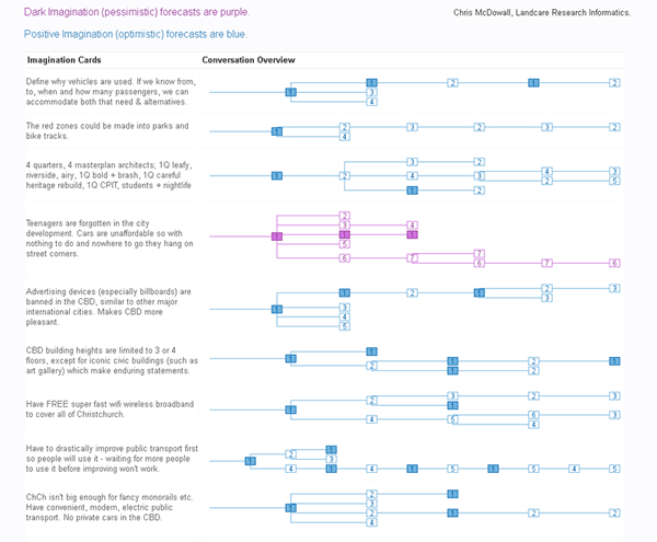 |
| Magnetic South Micro-Forecast Chain Reactions The graphic is an experimental visual overview of the most detailed conversations. Each graphic represents a conversation that is taking place. Each person in the conversation is represented with a number. The person who made the initial forecast is number one. The first person to reply is number two... and so on. |
Bob Frame says that consensus-based decision making has become increasingly popular over the last ten years, especially in areas where polarised views mean that competing priorities are difficult to meet. It is difficult because it often requires lengthy and expensive face-to-face meetings (and often lots of these if there are large numbers of stakeholders involved).
“Online participatory exercises can bring lots of people together at much lower cost (including time costs) than getting everyone physically assembled in the same room, and experiences around the globe are demonstrating how well these exercises can work.”
Christchurch Mayor Bob Parker, who was supporting the event, said Magnetic South was a great addition to the City Council’s successful ‘Share an Idea’ website and community expo initiatives.
“What makes Magnetic South different is we’re looking at the city from a future perspective. The decisions our forebears made in the 1800s, creating Hagley Park and the grid layout of our streets for example, continue to impact us today, and it’s important the decisions we make in redeveloping Christchurch also stand the test of time,” Mr Parker says.
This unique event – only one of a handful tried in the world - utilised new technology, and its limitations were exposed. Two hours before the event was meant to end, the US-based system crashed due to very heavy interest following an interview about the event on Kim Hill’s “Saturday Morning” radio show on Radio New Zealand.
“While the event was forced to end a little earlier than expected it still generated almost 9,000 ‘ideas’ on how to shape the city following several devastating earthquakes in the past nine months. This is an exceptional result that highlights a genuine community commitment to rebuild the city in a way that the community wants and in a way that will continue to attract talent and investment.”
Support for similar events has already been voiced by authorities leading the earthquake recovery as well as from other councils throughout New Zealand who are grappling with other challenging issues.
“Future events of interest to Landcare Research include more boutique crowd-sourcing events with perhaps no more than 500 people on quite specific issues in more focused environments. We will be discussing this with Christchurch City Council and the Christchurch Earthquake Recovery Authority,” Bob Frame says.
Further information:
Bob Frame
Biodiversity
Thinning ‘therapy’ for beech stands
A Landcare Research-led team has found that the stem diameter of 58-year-old beech trees in a thinned area of forest can be about double the stem diameter of trees in comparable unthinned stands. In addition, differences in timber yield are even wider than the four-fold increase expected from a two-fold increase in stem diameter growth.
The surprising findings came from revisiting two thinning trials that were set up by the former NZ Forest Service in the 1970s.Beech trees grow very slowly in natural forest and even-aged stands regenerating from felled forest tend to develop into dense thickets of saplings and pole-sized trees where competition between trees is strong and individual growth rates slow (in the order of 2 mm in stem diameter per year). Dominant trees are slow to emerge and are expected to lead to rotations of more than 120 years. Beech saplings respond well when competition from neighbours is reduced and exhibit rapid growth rates when grown in isolation. A simple thinning intervention and release from competition will promote tree growth rates and bring a number of associated benefits. Short rotations mean shorter exposure to windthrow, fire or insect attack, and make investments in silvicultural treatments financially more appealing. On top of this, the big logs that result from fast growth imply lower costs of harvesting and processing for well-priced wide boards.
Foresters have long recognized the utility of stand thinning. This led Dudley Franklin of the former NZ Forest Service to establish a number of thinning trials in regenerating beech forest in the early 1970s. Trials were mounted in dense young stands with stockings in the order of 10 000 stems/ha and thickets of up to 50 000 stems/ha. Candidate ‘crop’ trees were tagged and remeasured several times. In collaboration with Larry Burrows and Rob Allen (Landcare Research), David Henley (Scion) and Gordon Baker (private consultant), we have recently remeasured and assessed the response to thinning of silver beech (Nothofagus menziesii) stands to densities ranging between 3000 and 150 stems/ha, and of thinning mixed red (Nothofagus fusca) and hard beech (Nothofagus truncata) stands to densities ranging between 540 and 150 stems/ha. The work was co-funded by MAF Policy and a FRST Program on Sustainable Indigenous Forestry.
The outcomes of intense thinning (stem densities under 550 stems/ha) are remarkable. Mean stem diameter in 58-year old stands with 150 stems/ha is almost double that of unthinned stands (43.2cm compared to 21.1cm for red/hard beech and 35.9 compared to 17.3cm for silver beech). The somewhat faster diameter growth of red/hard beech and their taller stems meant that, at 58 years, merchantable volumes were up to 21 times higher in thinned mixed red/hard beech stands (191 m3/ha) and 7 times higher in thinned silver beech stands (127 m3/ha) when compared with unthinned stands. At 58 years yield tended to maximise at c. 190 stems/ha for red/hard beech stands, whereas it peaked arround 600 stems/ha for the more shade-tolerant silver beech.
 |
 |
| No photographic tricks. Both photos were taken with equal magnification and angle of view (ie focal length) on contiguous even-aged (58-year-old) mixed red and hard beech stands. One of the stands (bottom image) was left unthinned (~ 14 000 stems/ha) whereas the other one was thinned to 250 stems/ha. |
Will such treatments pay off? A first assessment with discounted cashflow analysis for silver beech stands collaboratively undertaken with David Evison, Adam Sewell and Euan Mason at the School of Forestry, University of Canterbury, indicated that thinning operations are currently unprofitable for timber production due to overhead costs and discounting (time value of money). The estimated revenue from trading carbon credits was substantially greater than that of timber production with positive revenue in light thinnings with high biomass accumulation. This economic assessment sets the precedent but will require deeper examination of budgeted costs, associated risks and values gained from managing different beech species for either timber production or carbon farming.
Where to from here? Various other trials were mounted by the former NZ Forest Service between the 1960s and 1980s. These trials constitute an enormous investment and although plot maintenance has mostly been discontinued since the 1990s, we know that some tagged trees can be relocated and valuable information can be obtained from them. We intend to recuperate and remeasure these trials to quantify and demonstrate the gains in tree growth, merchantable timber yield, log quality, and carbon sequestration that can be attained from thinning and pruning a wider range of beech species, over a broader range of ages, and on a more diverse range of sites than previously attempted. We are currently seeking funds to carry on with this work.
Further information:
Tomás Easdale
Beating the beetle bug – new biocontrol agent for tradescantia
 A frustrating two-year delay in releasing a biocontrol agent for one of New Zealand’s most widespread and problematic weeds, tradescantia (Tradescantia fluminensis), is now over.
Landcare Research got permission from ERMA to introduce the tradescantia leaf beetle (Neolema ogloblini) in New Zealand in 2008 but its release was delayed by the discovery of a gregarine gut parasite infecting the beetles held in containment.
For the past two years Landcare Research scientists have been working to eliminate the bug from the beetle populations.
Towards the end of last year three generations of gregarine-free beetles were achieved, resulting in MAF giving permission to release the beetles from containment.
Researchers beat the disease by adopting high levels of hygiene for adults and newly laid eggs, reducing the likelihood of infection, and low levels of hygiene for developing larvae kept in strict solitary confinement.
“By not keeping things too clean at this point any parasites that may be present are given the opportunity to build up to detectable levels in individual beetles, so we minimise the risk of failing to detect very low levels of infection,” says researcher Lindsay Smith.
“Any eggs or offspring from infected adult beetles can then be culled. All this information is recorded, e.g. we have full family trees for all of the leaf beetles and can trace each back to their great grandparents! This knowledge also helps us to reduce inbreeding by making selective crosses between different lines before release.”
Eighty pupae and adults were moved from Landcare Research’s containment facility at Lincoln to its Auckland site in late December. Mass rearing by Auckland staff led to the first release in an Auckland reserve recently. Widespread releases are planned for spring 2011.
As its name suggests, the tradescantia leaf beetle feeds on the foliage of the weed, which has become widespread in frost-free parts of the North Island and parts of the South Island. Thriving in shaded areas of gardens and bush, tradescantia grows densely on the ground preventing regeneration of desirable plants. Earlier research has shown that this weed is a threat to regeneration, and hence long-term survival, of indigenous forest in northern New Zealand.
Auckland Council has recently applied to ERMA for permission to release two further tradescantia agents that Landcare Research has been studying: the tip-feeding (Neolema abbreviata) and stem-boring (Lema basicostata) beetles, with a decision likely within 6 months.
Routine disease tests have found low levels of different species of gregarines in both beetle populations and Landcare Research is confident the methods used to rid the leaf beetle population of the parasite will also work for the stem-borer and tip-feeder beetles. Gregarine-free populations of both species should be available for release by the end of this year.
“We have pursued this trio despite the parasite problems because they attack different parts of the tradescantia plant (leaves, stem, stem-tips) and should make a complementary team,” says Lindsay.
“Defoliation experiments indicate that the sum effect of their feeding will be magnified in the presence of each other. Just wait until we get them out there!”
Meanwhile, work is continuing in Brazil with a fourth promising agent, the yellow leaf spot fungus (Kordyana brasiliense).
This project is funded by the Department of Conservation, National Biocontrol Collective and the Ministry of Science and Innovation under the Beating Weeds programme.
Further information:
Lindsay Smith
For more information about the tradescantia leaf beetle and other biocontrol news see What’s New in Biological Control of Weeds?
Rabbits on the rise
 It’s almost 15 years since the release of the rabbit haemorrhagic disease (RHD) which decimated rabbit numbers over large areas of New Zealand. However, in the intervening years rabbits have developed increasing immunity to the RHD virus and their numbers have started to recover.
Increased rabbit densities have led to resurgence in the use of conventional control tools, including baiting with either 1080 or pindone. Landowners are required to control rabbits when numbers exceed specified population levels and some landowners are again incurring high rabbit control costs.
Due to growing concern about the numbers of rabbits infesting our drylands, for the first time in more than 10 years Landcare Research scientists, led by Bruce Warburton, have received funding from the Crown to extend recent research on possum control to the control of rabbits.
The research has three main strands: (1) reducing the cost and amount of toxic bait used in aerial baiting, (2) identifying cost-effective strategies currently used by farmers for secondary control, and (3) understanding the toxicology of pindone poisoning in order to reduce the cost of application and its potential impacts on non-target species.
As a first step, published papers and reports from previous relevant research were catalogued within a searchable web-accessible bibliography (http://rabbits.landcareresearch.co.nz). The catalogue helped identify key research that could be used to update current best practice for controlling rabbits with aerially sown 1080-carrot bait. Such control typically involves sequential sowings of 20–40 kg each of prefeed (non-toxic) and toxic bait per hectare, depending on rabbit density, and costs up to $100 per hectare. Based on research into baiting for possums, Bruce believes that current bait sowing rates and associated control costs for rabbits can be significantly reduced.
To test this hypothesis, Bruce and his team are working with Otago Regional Council staff to develop and run a series of trials this winter to test a range of different bait sowing rates and applications that could reduce costs by as much as 50% and the sowing rate of bait by 66%.
Some farmers undertake secondary control of rabbits to slow or halt population recovery. To determine how control is currently being carried out, farmers are being interviewed to identify the control methods they use based on variations in habitat, percentage cover, farming practices, and the density of rabbits on their property. Preliminary results show that investment in rabbit control varies greatly; some farmers have long-standing control programmes costing tens of thousands of dollars per year, whereas others invest very little, instead relying on the RHD virus and the even the efforts of meat shooters to suppress rabbit numbers.
Farmers and rabbiters engaged in control use a wide range of tools to limit rabbit populations. Shooting is the most common control method used, though its application varies. For example, in areas where access by 4WD or motorbike is possible, night shooting is effective when rabbit densities are low. On steeper, less accessible country, rabbits are shot from helicopters. Other complementary methods include fumigation of burrows and patch-poisoning with pindone.
Pindone (a first-generation anticoagulant toxin) is used by some farmers and contractors to control rabbits because of the regulatory and stock-withholding-period requirements when using 1080. However, as with other pesticide uses, baiting with pindone raises concerns over toxin residues and risk to non-target species, but far less is known about these aspects of pindone use in comparison to 1080 use. Landcare Research toxicologist Penny Fisher has been assessing the residue concentrations of pindone in tissues from caged rabbits after they have eaten a lethal amount of pindone and has found relatively high levels of the toxin in rabbit liver and fat. Tissue testing is ongoing, and the final results will be used to review assessments of risk to non-target species that prey on or scavenge rabbits and to help optimize the application of pindone baits to both minimize costs and secondary poison risks.
Further information:
Bruce Warburton
This article originally appeared in Landcare Research’s vertebrate pest research newsletter, Kararehe Kino.
New forest and shrubland classification system
The monitoring and management of changing forest and shrubland in New Zealand will benefit from a comprehensive new classification system.
More than 70% of New Zealand’s forest and shrubland has been lost in the 800 years since human arrival through fire, land clearance and logging.
“Remaining forest and shrubland continues to be impacted, for example by invasive species and land-use change, so an up-to-date depiction of the composition, extent and structure of these woody communities, at a range of scales, is valuable,” says Project Leader, Dr Susan Wiser.
Landcare Research has used the LUCAS (New Zealand Land Use and Carbon Analysis System) plot network, established from 2002 to 2007 primarily to monitor carbon stocks, to reclassify our forest and shrubland cover.
Using the 1177 nationally representative vegetation plots (positioned on an 8km x 8km grid across the country), the researchers were able to identify 24 different broad vegetation classes termed ‘alliances’.
Each alliance was evident at between 19 and 105 plots, with each comprising an estimated land area of 144,000–794,000 ha.
“Stand structure data suggest that 16 of these alliances are largely stable whereas eight will undergo compositional change, so the new classification system will be valuable in managing that change,” says Susan.
“Previous classifications and vegetations maps, although based on the best information and analytical techniques available at the time, were either out-of-date, too broad, or didn’t accurately depict the actual vegetation.
“For example, in some areas the maps were largely dependent on aerial imagery, so they focused on canopy composition, or could not accurately distinguish between species such as the different beech (Nothafagus) varieties. From an applied perspective, this is important as Nothofagus now is the main indigenous New Zealand species managed for timber production in New Zealand. Landowners developing sustainable management plans, as required by law, need a framework to describe the specific type of Nothofagus forest they plan to manage, in a consistent way that can be readily placed in a national context.”
So what are the most obvious differences between the latest and previous classifications?
“Our new classification provides more differentiation of types in our most widely distributed forests and highlights the extent of alliances in disturbed landscapes, as well as those that are compositionally dynamic, and those invaded by exotic species. These are areas with high potential for future carbon sequestration and biodiversity enhancement, but still remain poorly understood.”
Work on the classification was funded by DOC, MAF’s Sustainable Farming Fund and Landcare Research internal funding.
Further information:
Susan Wiser