Issue 6, September 2012
In this issue:
|
Editorial
Welcome to this latest edition of our Landcare Research newsletter for MfE and, for the first time, EPA staff; hence the minor name change from ‘MFE Update’ to ‘Environment Update’. If you’re receiving this for the first time, we hope you find it interesting and useful.
‘Driving innovation’ in New Zealand’s management of biodiversity and land resources is our core purpose, and as we drew up a list of content for this edition of our newsletter, the word ‘innovative’ certainly came to mind.
The concept of a pest-free or predator-free New Zealand is definitely innovative. This aspirational goal is gaining traction across community, business, government and science sectors, and in this edition Andrea Byrom provides some thought-provoking insights into the opportunities and challenges.
Also innovative is the treatment of Te Urewera National Park in the recent Tuhoe Treaty settlement. At a time when many of the discussions about major land resource decisions are adversarial, it’s great that research and consultation with all stakeholders can play a constructive part in achieving a good outcome.
We mention innovative new tools such as New Zealand Forest and Agriculture Regional Model (NZ-FARM) to help decision makers assess the economic and environmental impacts of environmental policy; and the third version of the Land Cover Database (LCDB), a valuable record of the changing land cover in this country.
Finally, in determining our core purpose, the Government signalled that it wanted science organisations to work more collaboratively together and to engage better with users of our science. The new National Land Resource Centre, which is being supported by Landcare Research, is a great example of this new and innovative working environment.
I hope you find this edition interesting, and as always, I’d welcome your feedback.
Alison Collins
Director NLRC / Portfolio Leader
Biosecurity
 Can we really rid NZ of pests or predators?
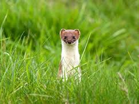 The appealing concept of a ‘predator-free NZ’ or ‘pest-free NZ’ (PFNZ) is gaining an increasing amount of air-time. But is such an audacious goal really possible?
Dr Andrea Byrom, the leader of our Managing Invasive Weeds, Pests and Diseases science portfolio recently teamed up with Susan Timmins, the Department of Conservation’s Threats Science and Technical Manager to present a Wellington seminar on PFNZ.
Here Andrea explains the concept.
What is PFNZ?
Predator-free is not the same as pest-free, although they are related concepts. Momentum and interest in the general concepts are building. Some high profile initiatives are emerging:
- Conservation Minister Kate Wilkinson’s aspirational goal of pest-free New Zealand was stated in National’s conservation policy along with the development of a Biodiversity Forum at: http://www.national.org.nz/PDF_General/Conservation_policy.pdf.
- The predator-Free NZ initiative led by Les Kelly and Forest & Bird. A Predator-Free NZ summit held last March decided that the species of focus should be possums, rats, mice, and mustelids (not cats or rabbits, and not ungulates such as deer, goats, etc).
- Numerous philanthropists and businesses are signalling interest in PFNZ. Sir Paul Callaghan’s speech at Zealandia in Wellington last February increased the public profile of the benefits of removing pests and nurturing native wildlife for the enjoyment of all, as well as economic advantage. After Sir Paul’s death, the idea was further profiled in an editorial in the NZ Listener: http://www.listener.co.nz/current-affairs/science/sir-paul-callaghans-crazy-idea/
The concept of PFNZ does not currently include weeds or invasive invertebrates: it’s focussed on mammal pests.
Is PFNZ possible?
The short answer is: we don’t know yet. Most want to believe it is possible. Many conservationists and scientists remember the 1974 workshop to discuss the possibility of removing rats from any island >2ha. Some said it was not possible. Yet just 30 years later, Campbell Island (11,300ha) was declared pest free in 2005 and remains New Zealand’s largest pest free island, and DOC are close to declaring success from their current efforts to eradicate stoats and red deer from Resolution (20,800 ha) and Secretary (8140 ha) Islands in Fiordland, which are just 800m and 500m from the mainland respectively.
Learning from this experience, ever-larger islands such as Stewart Island (174,600 ha) and Great Barrier Island (28,500 ha) are now being mooted, and people are also beginning to think about how we could tackle large ‘defendable’ mainland areas such as Banks and Otago Peninsulas.
The islands and mainland areas mentioned above are significantly larger than has ever been attempted before – anywhere in the world. Internationally, the idea of eradicating invasive species from inhabited islands is regarded as one of the next major challenges among the ‘island eradications’ community. For example, the consultation process around eradication of rodents from Lord Howe Island has taken several years, and is continuing. It is acknowledged that, given the potential challenges ahead for PFNZ, it could easily take decades to achieve.
There are a number of challenges ahead:
- Technical – having the right traps, toxins, and as-yet-unthought-of tools for all the species of interest. Biocontrol is an option in the future, but requires a lot of research and international collaboration.
- Social and cultural – engaging people and getting them on board. This would require huge commitment and effort, would be inter-generational, and would transcend political and cultural boundaries.
- Ecological – understanding rates of reinvasion into ‘cleared’ areas, detection at low density in order to find ‘every last mouse’, understanding impacts of the species on native biodiversity, and dealing with the problem of ‘ecological release’. For example, if ferrets and stoats are removed, will we have a greater rabbit problem on our hands?
- Policy and regulatory – who ‘leads’ PFNZ; how it all fits together at a national scale.
- Financial – the facts and figures are sobering. For example, NZ’s land area is approximately 26.9 million ha. Current control costs for multiple pest species can be as high as $20/ha depending on the tools and strategies used. Research by several Landcare Research staff is aimed at reducing the $20/ha figure significantly. Nevertheless, the operational cost of pest-free NZ could therefore be as high NZ$27B! (plus administration, public consultation, project management and coordination, infrastructure, HR staff for hiring of contractors, compensation for lost earnings by wildlife harvesters, etc.).
General consensus
The general consensus out of the Predator-Free NZ summit was to start with large islands and large chunks of the mainland, and learn adaptively as we go, through evidence-based research initiatives, community engagement, and with support from agencies and industry.
Even this is a huge logistical, financial and social challenge, and has a long time horizon (2100 has been mentioned). PFNZ is therefore a long term goal, and possibly will remain an aspirational goal. We may end up focussing on the pragmatic goal of long term suppression of pests over very large scales, to achieve significant gains for biodiversity, rather than killing all pests per se.
What is certain is that the environmental, economic and social benefits of PFNZ are so significant that interest in the possibility, and the air time it is receiving, will only increase.
Further information: Andrea Byrom
Cost-effectiveness of weed biocontrol
The savings created by just one biocontrol agent, the St John’s wort beetle, more than pay for all the other weed biocontrol programmes ever undertaken in New Zealand, according to a new study.
The economic analysis by Simon Harris (Harris Consulting) and Landcare Research’s Simon Fowler looked at the cost-effectiveness of releasing biocontrol agents against weeds in New Zealand.
As Simon Fowler explains, such assessments are rare in this country. “There isn’t much demand for retrospective studies as sponsors would rather spend money finding new biocontrol agents, and it has not been considered a priority by funding agencies. Also the long-term nature of biocontrol can mean that it may not be appropriate to undertake an economic analysis for several decades after agents are released.”
Landcare Research began by gathering data on successful agents such as the St John’s wort beetles (Chrysolina spp.).
At the time that beetles were first released in the 1940s, St John’s wort (Hypericum perforatum) was rapidly expanding in distribution, particularly in high country pastures. By the 1980s, the beetles were successfully controlling the weed.
To assess the economic gains, it was first necessary to look at results from ecoclimatic models. These were produced by Grant Humphries (University of Otago) using data provided by Landcare Research. The models were used to predict where the weed is capable of invading and to determine what its potential range would have been in the absence of any control.
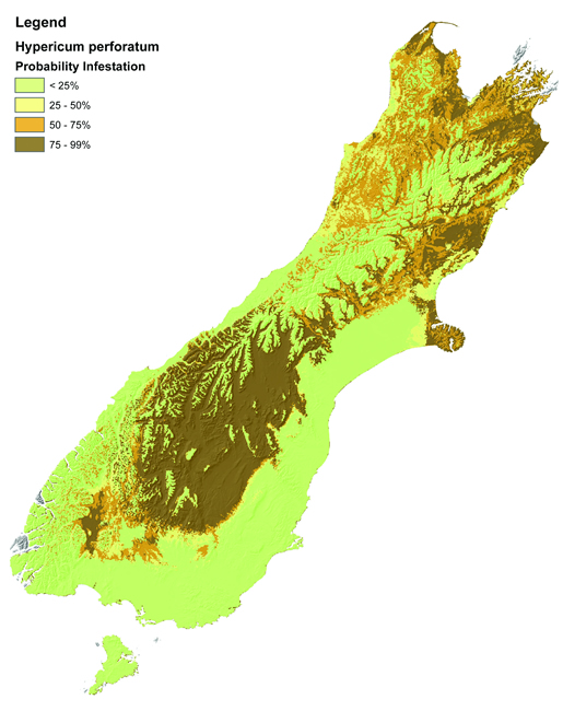 |
| The potential distribution of St John's Wort in the South Island. |
Various filters were added into the model to create a realistic scenario. For example, only areas of pasture used for sheep, beef and deer farming and where there was a high probability of St John’s wort infestation were used.
The model suggested that 660,000 ha of the South Island would have been badly infested if St John’s wort had been allowed to grow unfettered until 2042. The negative impact from this level of infestation (based on loss of pasture and grazing to farmers) was calculated to be $109/ha with a smaller cost of $6/ha for manual weed control.
The final figures suggested that the Net Present Value (NPV) of the introduction of the beetles is between $140 million (given a conservatively slow rate of spread) and $1,490 million (with a faster rate of spread) over 70 years. The respective benefit-to-cost ratios are therefore an impressive 10:1 and 100:1.
Another assessment has shown that the ragwort flea beetle (Longitarsus jacobaeae) is savings farmers about $7 million per year in the areas where it is effective. With the establishment of the ragwort plume moth (Platyptilia isodactyla) in wetter areas of New Zealand, where the flea beetle has not been effective, it’s anticipated the benefits could be as high as an additional $5 million per year.
Funding for this project was provided by the former Ministry of Science and Innovation (now the Science and Innovation Group of the Ministry of Business, Innovation and Employment) to the Beating Weeds Programme and Landcare Research’s Discretionary Capability Fund.
Further information: Simon Fowler
This is a summary of an article in the latest edition of our ‘What’s new in Biocontrol of Weeds?’ newsletter
Sustainable Development
Assessing transport’s lifetime impact
 Sealing unsealed roads, using durable construction techniques on hilly roads, and locally sourced steel rail tracks are three key ways of reducing the lifetime environmental liabilities of road and rail-based transport services.
A Landcare Research study for the New Zealand Transport Agency used whole-of-life thinking to assess the environmental impacts of transporting passengers and freight on New Zealand’s road and rail networks.
Christine Harper, who managed the research project, said researchers initially intended to look at the total life cycle energy consumption, greenhouse gas emissions, stormwater contamination and costs of the various transport options.
“However, the commercially sensitive nature of the costs of building and maintaining transport infrastructure meant that the information we needed was not available. The data on stormwater also proved inadequate for a detailed assessment.”
In the end, the study focussed on greenhouse gas emissions, total energy demand and the quantity of contaminants delivered to water bodies by road infrastructure. Current construction and maintenance practices were used for the assessments, as were the current vehicle fleet and rolling stock.
The assessments found that for road pavements, the type of construction used significantly altered the road’s lifetime energy use and greenhouse gas emissions.
This was significant, given that one third of the country’s total road network currently has a loose surface. Roads with loose surfaces have high maintenance needs (and also high tyre-pavement resistance and lower traffic speeds, leading to higher fuel use), which boost their energy use and emissions in the long term to four times that of roads with sealed wearing courses.
Sealing the currently unsealed lengths of the road network is therefore an effective way to significantly reduce resource use associated with road infrastructure. Unbound granular pavement systems, with a sealed wearing course, provided an environmentally friendly option.
The terrain that roads are built on also contributes to their impact, with significant increases in energy use and emissions for hilly, as opposed to flat terrain. As a result, the report recommends that more durable pavement construction types, with lower maintenance needs, are selected for roads in hilly areas.
With respect to rail, the study found that the steel rails used to construct railway tracks accounted for nearly half of their lifetime greenhouse gas emission and energy use. The current practice of sourcing steel rails from China had a significant impact, and the report recommended that a local source of steel, with lower carbon emissions, should be sourced for future infrastructure projects.
Using rail for passenger and freight transport leads to greater reductions in both energy use and emissions, when compared to all the different modes of road transport, especially when electrified rail is used for suburban passenger transport (as opposed to diesel rail).
For road-based passenger transport services, fuel use was particularly influential, and using smaller lighter vehicles and increasing vehicle occupancy would noticeably reduce the impact of trips.
For road-based freight services, however, the choice of vehicle and infrastructure was just as influential as fuel use. The highest energy and emissions intensity was calculated for light commercial vehicles, with intensity decreasing as truck size increases (intensity for a light vehicle is over twice that of a large truck).
Further information: Christine Harper
The report: Lifetime liabilities of land transport using road and rail infrastructure, NZ Transport Agency research report 462, is available online at www.nzta.govt.nz/resources/research/reports/462
Assessing impacts of environmental policy
 Assessing the economic and physical impacts of environmental policy has long perplexed decision makers but a new tool from Landcare Research looks set to change that.
The New Zealand Forest and Agriculture Regional Model (NZ-FARM) was developed to allow central government agencies, regional councils and industry to systematically assess the economic and environmental impacts of environmental policy – including limits, allocation options, taxes - and resource constraints such as water availability.
Researcher Suzie Greenhalgh says that for example, the model can be used to simultaneously assess how meeting different regional water quality limits and the implementation of the NZ Emissions Trading Scheme can impact catchment-level farm income.
The model optimises potential farm income across a catchment against the environmental impacts of land use (pastoral, arable, horticultural, forestry, scrub or conservation) and land-use and management change. The model also includes soil and weather variability across the catchment.
“To enable the agricultural sector to respond to policy changes and resource constraints farmers can change land use or adopt management practices with lower environmental impacts,” Dr Greenhalgh says.
“The management practices available to farmers currently include changing stocking rates and fertiliser regimes, applying nitrogen inhibitors, and using feedpads for dairy operations.”
Researcher Adam Daigneault says the model focuses on greenhouse and water environmental constraints, accounting for greenhouse gas emissions from agriculture and forestry, forest carbon sequestration, water use and water constraints, and nutrient (nitrogen and phosphorous) losses. The water quality impacts are modelled using OVERSEER® - an agricultural management tool that assists in examining nutrient use and movements within a farm to optimise production and environmental outcomes - while the greenhouse gas emissions and carbon sequestration are based on the methods used to derive the annual national inventory of greenhouse gases.
“Over time additional ecosystem services, environmental constraints and farm management options will be added to the model and currently, water yield and pollination services are being incorporated,” Dr Daigneault says.
The model was originally developed for the Hurunui/Waiau River catchments in the Canterbury region of the South Island and the Manawatu River catchment in the North Island and it has been developed to enable a relatively straightforward customisation to other catchments. To date, NZ-FARM has been used to assess the benefits and impacts of:
- Increases in water storage from capital improvement projects such as water storage infrastructure,
- Proposed water quality caps or limits such as those on nitrogen and phosphorus loads, and the allocation of these limits within a catchment,
- Mandatory good management practices for agriculture
- Input and output taxes
- Implementation of NZ-ETS on the forestry and agricultural sectors,
- Regional afforestation schemes,
- Implementation of new farm technology and good management practices,
- Increases in farm input costs and/or product prices, and
- Combinations of the above options.
Further information: Adam Daigneault
Toyota greens its dealer network
 Toyota has extended its environmental leadership in New Zealand by being the first national dealership network to implement Landcare Research’s Enviro-Mark certification programme.
Enviro-Mark is a five-step programme (Bronze to Diamond) that provides the resources and support for organisations to implement credible and effective environmental management systems.
In 2010, Toyota trialled Enviro-Mark with selected dealers, and by the end of 2011, 66 of its 67 dealer sites had achieved Enviro-Mark Silver certification. By the end of this year Toyota expects all its dealers to have achieved a minimum of Enviro-Mark Gold certification.
At the Gold level of certification an organisation has confirmed its compliance with applicable health, safety and environmental legislation, identified their significant environmental issues, and made quantifiable progress in improving their environmental performance.
Landcare Research Chief Executive Dr Richard Gordon says the servicing of cars can have a major impact on the environment if not managed correctly. “It is tremendously pleasing to see a company as large as Toyota lead the way by taking responsibility for addressing these issues across its dealer network.”
Toyota has also been managing and offsetting the carbon emissions of its New Zealand distribution operations since 2005 under Landcare Research’s CEMARS and carboNZero programmes, another first for the auto industry in New Zealand.
Further information: Chris Bailey
Land Environments
National Land Resource Centre (NLRC) launched
 The National Land Resource Centre, which we signalled in our last edition, is now up and running. The collaborative centre aims to improve the way science is used to enhance the land resource.
“I can’t think of a more powerful outcome than making sure that the top 15cms of this country are appropriately stewarded,” said Ministry for the Environment CEO, Dr Paul Reynolds, at the NLRC opening.
“The launch of this centre comes at a time when our future depends more than ever on robust, evidence-based environmental intelligence and a collaborative approach to ensure we effectively manage our natural resources. It comes, too, as a time when there is a lot more attention being paid to core priorities and value for money, and in these cash-strapped times it makes an initiative like this all the more important.”
This video, highlighting the important of the land, also screened at the launch.
NLRC Director Dr Alison Collins says much of the focus is now turning to establishing priorities for the centre and on capability development.
Further information: Alison Collins
Research support for Tuhoe’s Treaty of Waitangi Settlement
 The details of the Crown’s recent Treaty of Waitangi settlement with Tuhoe have been well reported but a lesser known detail is the work of Manaaki Whenua (Landcare Research) in helping to facilitate the process.
Manaaki Whenua has worked with Tuhoe for 20 years, providing conservation management research and advice particularly around indigenous forestry, possum control and the restoration of kiwi and kereru populations. In the past three years that relationship has extended to research around the governance and management of protected areas.
Together with Tuhoe and other iwi representatives, we assessed how models of protected area governance and management have been implemented in Australia and Canada. We also extensively canvased the principles and priorities of many Te Urewera stakeholders by conducting interviews and holding a summit in May where these issues were thoroughly discussed.
Manaaki Whenua researcher, Dr Phil Lyver says that by the end of the May summit, there was a consensus among park stakeholders that Tuhoe should have a lead role in the future management of Te Urewera.
“People should understand that Tuhoe’s management philosophies for the area are fundamentally aligned to the care and protection of land that most of us associate with a national park,” says Phil.
“This is a major decision about a very important area of land with high biodiversity, cultural and recreational values.”
Further information: Phil Lyver
New Land Cover Database Released
The third version of the Land Cover Database (LCDB) – the authoritative record of the state and changes in land cover in New Zealand – has been produced by Landcare Research.
LCDB v3.0 has been compiled over the past year from about 160 satellite images of New Zealand that were captured in the summer of 2008/9.
The database is extensively used by policy makers and land managers in central and regional government for uses such as state of environment monitoring, forest and shrubland inventory, biodiversity assessment, trend analysis and infrastructure planning.
Users can download the database from Landcare Research’s data portal and use a GIS (Geographical Information System) to manipulate the data and produce the information they require.
Building on the first two LCDB versions, produced in 2000 and 2004, the latest database makes use of improvements in the resolution of satellite imagery, as well as Landcare Research’s advances in image processing technology to provide an accurate record of New Zealand’s land cover at 2008/09.
With just under 450,000 polygons, or delineated areas, the database classifies all land cover under 33 classes at three time steps (the summers of 1996/97, 2000/01 and 2008/09).
“We’ve had great support from users of the database, particularly regional councils and Department of Conservation, who have extensively checked much of the data,” says Project Manager, Peter Newsome.
“Utilising the half million dollars’ worth of satellite imagery already acquired by Ministry for the Environment’s LUCAS (Land Use and Carbon Analysis System) programme has made LCDB v3.0 a very cost-effective revision of this nationally-significant database.”
Work will begin shortly on the next version of the LCDB database, using satellite imagery shot last summer.
In a parallel research programme, Landcare Research is studying ways to improve the development of land cover databases in the future. “A key goal is to make even better use of sophisticated computer technology to interpret the satellite imagery, so there is less ‘hand-digitising’. The manual work would largely be limited to checking the data.”
The LCDB project is funded by the Ministry of Business, Innovation & Employment (MBIE).
Further information: Peter Newsome
Monitoring and managing regional water quality issues
 With water quality issues becoming more prominent in New Zealanders’ thinking, the pressure is mounting on regional councils to effectively manage the cumulative effects of land use on water quality.
Landcare Research has been working with Environment Canterbury to try to develop more effective mechanisms for managing land use (and associated nitrate leaching) to meet water quality limits for the region.
We’ve been doing this work at farm, catchment and regional scales.
At the farm-scale, in a simulated study, we showed that current methods and technology for measuring leachate under grazed pasture are inadequate. Impractical numbers of measuring devices are required to accurately estimate average leaching from a field and this is critically important given this type of data is used by researchers to develop and evaluate farm-scale leaching models, and some regional councils are hoping to ensure compliance with nutrient discharge limits through such measurements.
Meanwhile, the spatial model AquiferSim (developed with Lincoln Ventures) assesses the impact of potential land intensification options on water quality in aquifers and spring fed streams and takes only minutes rather than weeks as with more complex models. It can be used where there is limited geo-hydrological data (good information is only available for a few aquifers in New Zealand).
Researcher Linda Lilburne says AquiferSim was tested in the Central Canterbury Plains (where there is good data) and in the Hurunui River area (where there is only poor data) and the modelling work contributed to the Environment Canterbury’s Land Use and Water Quality Project, a collaborative process with stakeholders that resulted in the Hurunui and Waiau River Regional Plan. We are now working with Environment Southland to apply AquiferSim to the mid-Mataura River basin.
Our new spatial model of contamination risk at the regional scale draws on data in S-map and relevant research on contaminant pathways. This helps land managers determine where mitigation practices are needed, and enables regional councils to apply more appropriate consenting rules for effluent disposal and septic tank discharge fields.
We used an updated regional nitrate-leaching map to provide statistics on the impact of nitrate thresholds being considered for the draft Canterbury Land and Water Regional Plan. We also developed a new method for allocating a catchment-scale nutrient limit between farms. This focuses on more intensive mitigation practices for land where there is a nitrate contamination problem, i.e. intensive land use on leaky soils in catchments known to have poor water quality.
Further information: Linda Lilburne
Biodiversity
New organisms register to benefit wide range of decision makers
 The New Zealand Organisms Register (NZOR), a new web-based record of species important to New Zealand was launched by the Minister for Primary Industries, Hon David Carter, at the recent Living Data Conference in Wellington.
Designed and developed by Landcare Research, the New Zealand Organisms Register provides up-to-date information on over 94,000 animals, plants, fungi and bacteria of significance to our economy, environment and society, making it the most complete digital species catalogue of any country in the world.
Mr Carter says the benefits of the register will be widespread wherever species names are needed in the conservation of threatened species and management of ecosystems, provision of biosecurity responses and decisions on species introductions.
“It will also be of value to the primary industry for export clearances, and regional councils in pest and land management,” says Mr Carter.
“It will help conservation managers and scientists to make quicker decisions at less cost, and will enable information about our rich indigenous biodiversity to be shared more easily with the public. It will also assist our biosecurity agency to protect us from new pests.”
The register uses state-of-the-art data sharing technology that links the research community with management agencies. With the technology users can access species data from research providers both here and overseas, meaning NZOR will be kept up-to-date as new knowledge emerges.
Mr Carter describes NZOR as globally-unique in its ability to harvest and integrate data.
“The Department of Conservation (DOC) played a key role in the creation of the NZOR, helping to fund its development over the last three years. DOC was instrumental in getting cross-sector support for this strategically-important register, which will benefit conservation and primary industries alike,” says Mr Carter
Key partners in NZOR include DOC, Ministry for Primary Industries, Environmental Protection Agency, Ministry of Business, Innovation and Employment, NIWA, Landcare Research and Te Papa.
Further information: Jerry Cooper
Landcare Research Link – linking research and policy in Wellington
Landcare Research has now delivered 10 ‘Link’ seminars in Wellington. The lunchtime series has proved popular with staff in a variety of government agencies and related policy-making organisations.
Seminar organiser, Christine Harper: “We have now ‘entertained and informed’ over 120 people, and the growing number of ‘frequent flyers’ encourage us as to the helpfulness and relevance of this type of delivery. The science teams at Landcare Research have also enjoyed the opportunity to present and discuss their work in an informal way across a variety of policy agencies.
“The various topics tackled so far have included water governance, policy innovation, pest eradication, catchment level economic modelling for environmental policy-decisions, soils and S-map Online, global change implications for NZ, biodiversity and ecosystems services and Maori land.
The Link seminars are held on the last Tuesday of the month. “They are over lunch so that people can refresh mind and body together…. a basket of fruit and sweet treats keeps us refreshed and energised!”
September will see us present two Link seminars – on related but different ecosystems services topics. Tomorrow (18th September) we will be at MfE with results from the Ecosystems Services for Multiple Outcomes programme, and this will be followed on 25th September with a session at DoC where we review global and national developments in ecosystems services for business.
If you would like to be included on the mailing list contact Christine Harper
Please note:The newsletters are to keep MfE and EPA informed about current research projects. The news items may include interim results that have not been peer reviewed. They should not be disseminated or quoted without first contacting the person mentioned at the end of each item.