Issue 3, April 2011
In this issue:
Editorial
I imagine the day-to-day challenges of working in local and regional government have been put in perspective by the truly devastating issues that have faced the Christchurch City Council and Environment Canterbury since 22 February.
Just when we thought we were enduring the unimaginable, our disaster was put in perspective by events in Japan. As I communicate with friends in the adjacent Ibaraki region of Japan, where I worked for three years in the agriculture sector, I feel the same survivor guilt that people outside Christchurch have told me about.
Our Landcare Research head office is at Lincoln, 20 minutes drive from Christchurch, where we have 200 of our 400 people. Many have been impacted by and involved in the response to the Christchurch disaster. Sixteen of our staff joined the Civil Defence’s Operation Suburb for five days and others assisted in their own neighbourhoods and with food delivery. We were pleased to be able to make their time available because our people very much wanted to help the community. Other staff are volunteers in Urban Search & Rescue and the Fire Service who were on the front-line.
Our image processing experts were quickly on the job of helping the response effort by processing and enhancing optical satellite imagery of the city and its surrounds. That capability to provide high-resolution ‘eye-in-the-sky’ images following an emergency (and for a range of other territorial authority management applications) is explained in this edition of our newsletter by Informatics researcher, Stella Bellis.
As Christchurch bounces back, we will be involved in other ways, not least hosting re-located staff from DoC and Land Information NZ and co-hosting a workshop of urban science and innovation people from around the country to agree on how we as a community can help the recovery effort. The disaster once again reminds us of the need for good soils knowledge and green infrastructure solutions for our changing world. Look at the price of petrol now!
In this edition we describe a successful approach to incorporating Māori input into decision making that has worked well in the Motueka area, and together with Auckland Council we have just released our first biocontrol agent to tackle the problematic weed, Tradescantia.
I hope you find this edition interesting and, as always, I would welcome your feedback.
All the best,
Richard Gordon
Acting Chief Executive
Water
New Approach to Māori Involvement in Decision Making
 A new framework for Māori involvement in collaborative science and resource management projects is one of the key developments from the ten-year Integrated Catchment Management research programme on the Motueka River.
The research work with three Motueka iwi: Ngāti Rarua, Te Atiawa, and Ngāti Tama through their resource management agency, Tiakina Te Taiao Ltd, has attracted national attention from government and other Māori groups.
ICM researchers built a collaborative working relationship with these iwi, which led to the adoption of a GIS (geographic information system) and the development of a Māori Cultural Health Index for rivers, adapted from work by Ngai Tahu’s Gail Tipa.
The cultural health of the Motueka and Riwaka Rivers has been monitored by an iwi team and the information compared with research on the state of the rivers using scientific indicators. “This has shown that the two monitoring methods can provide an enriched and complementary understanding of freshwater systems,” says Garth Harmsworth of Landcare Research.
“The two methods can be used side by side by local government, community, iwi and hapū, and research agencies – for example in regional councils’ State-of-the-Environment monitoring of rivers.”
Te Atiawa’s Pat Park says previous generations of local Māori have found it difficult to clearly articulate their concerns about the deterioration of the natural environment. “This programme has given us the scientific bite that adds to what we’ve been saying and now, thankfully, we are starting to be listened to by those in power and they are understanding our worldview, which ultimately is not that dissimilar to theirs.”
Trevor James of Tasman District Council says the process led to better communication about the mutual appreciation of the natural resources. He said that including information about the values that iwi associate with places in the council’s Resource Management Plan would mean Māori issues could be considered up-front in decision making, averting visits to the Environment Court.
The ICM programme has been successful in meeting a range of Māori objectives, such as information collation for iwi management plans, defining the process for undertaking cultural impact assessments of development proposals under the RMA, improved input into resource consent decisions, and contaminated sites management.
The GIS-based information system for knowledge (Matauranga Māori) is now used daily for input into council resource management decision-making.
Importantly Māori also wanted to build the capacity of their people as ‘kaitiaki’ (guardians) of their natural resources. “We (the iwi monitoring team) have different skills and when we apply those skills the others learn. So we learn as much as we give,” says Pat Park. “That’s why we involve other people, so we pass on our knowledge - our kaitiakitanga.”
“Healthy land, healthy people; that’s it in a nutshell,” says monitoring team member, John Katene.
“I can see this working on my Dad’s lands up at Kahungnunu (east coast of the North island), which is where I hope to go and exercise it there,” says another team member, Hori Kahukura. “I know the people there will grab it with both hands.”
Garth Harmsworth says the ICM project has highlighted the importance of the Māori cultural perspective, and its contribution and knowledge for resource management throughout New Zealand.
“In Te Tau Ihu (the top of the south), this can be seen by the development of their overarching iwi pan-tribal resource management committee, enhanced GIS capability at the marae, hapū and iwi level, and the development and incorporation of iwi capacity as shown in environmental monitoring teams.”
Garth has documented the approach used in the ICM programme as guidelines for anyone wanting to consult with iwi. “We’ve developed some effective tools that are relevant right throughout the country.”
Further information:
Garth Harmsworth
Mapping irrigated land
How much irrigable land is there in New Zealand? Where is the growth occurring? Where will we need additional water storage?
Landcare Research has provided some answers to these important questions for central and regional government by mapping New Zealand’s irrigable land.
There is about 600,000ha of irrigable land in New Zealand, a figure that has increased rapidly in recent years. The area of land that can be irrigated is now reaching near total allocation, raising significant issue for decision makers.
The pressure on water use also means that tools for improving efficiency of use are needed. A map of irrigated land combined with a soil map will help optimise water use.
However, although farmers are well aware of where the irrigated land is, mapping at regional or national scale is not trivial. Regional councils hold information on the consented areas for extracting water from rivers or groundwater, but that doesn’t say how much of this water is actually used in any one year. In addition, water could be extracted in areas away from consented locations.
Landcare Research estimated the area of irrigable land by overlaying information on farm boundaries and resource consent locations. This exercise was done in five regions (Manawatu, Hawkes Bay, Wellington, Otago and Canterbury). But, this only estimates the potential for irrigation, not active irrigation. Satellite images can be used to detect greenness of the land and pivot irrigators. This information shows where irrigation actually occurs.
We tested this approach in two regions, Manawatu-Wanganui and Hawkes Bay, and used mosaics of Landsat ETM+ images acquired in 2001 and SPOT 5 images acquired in summer 2008. By overlaying the farms with freshwater resource consents for irrigation, we were visually interpreting the landscape to determine if the land was irrigated or not.
This preliminary study showed that the accuracy of the mapping relies heavily on the acquisition dates of the images. As shown on figure 1, the irrigated land was interpretable where the land was dry enough to distinguish greenness due to irrigation from greenness due to naturally lush pastures.
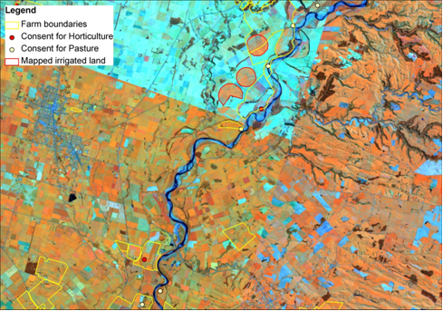 |
| Figure 1. An example of irrigated land (red line) mapped on a mosaic of SPOT images in false colours. Cyan colour represents bare ground (dry or ploughed fields, cities, roads), shades of orange represents levels of green pasture. The upper part of the mosaic was taken from imagery during a dry period. |
In the future, Landcare Research envisages developing a two-level approach:
- At the national scale, we can produce a map using a national database of resource consents compiled by MfE and farm boundaries. We can improve on the methodology by using simple rules to calculate the effective irrigated area in each property based on consented volume per day, and by removing obvious non-irrigated areas (e.g. uplands).
- At the regional scale, we can use satellite images to visually interpret irrigated land. We can identify the appropriate high resolution satellite imagery by assessing driest period using NIWA soil moisture deficit archives. Using any other ancillary information (aerial photos, GoogleEarth, regional council information), we can build on our previous experience to produce a 1:50,000 scale map of current irrigation.
Further information:
Carolyn Hedley
Anne-Gaelle Ausseil
Biosecurity
Predicting where and when possum browse will kill trees
 Where should land managers focus on possum control to avoid fatal browsing of native trees? Landcare Research scientist Pen Holland and her colleagues have developed a model to provide some answers.
Possums have been implicated as major drivers of the loss of biodiversity in forests in New Zealand. Although possums favour non-foliar foods such as energy-rich flowers and fruits (and such browsing may hinder long-term forest regeneration), foliage browsing is a significant cause of dieback and mortality of native tree species.
Untangling quantitative, causative relationships between possum density, observable damage and tree mortality is difficult, not least because such data are highly variable, both within and among forest sites. For example, while both Landcare Research and the Department of Conservation use the Foliar Browse Index (FBI) method to assess forest tree condition, it provides only snapshots of forest health.
Pen Holland and colleagues have been using FBI data to formulate and parameterise a mathematical model of foliage growth, turnover and consumption, to answer two questions:
- How much of a tree’s foliage do possums have to eat in order to kill it?
- To what level does foliage consumption by possums have to be reduced in order to protect trees at a particular location from browse-induced mortality?
The model framework is based on interacting processes at different spatial scales, from individual leaves to tree canopies, through to large areas of mixed forest.
Browse damage occurs when part of a leaf is eaten by a possum, and the FBI records the ratio of whole to partially browsed leaves in the tree canopy. For this reason, the model incorporates the within canopy foraging strategy of possums, such as browsing entire or partial leaves indiscriminately, or only browsing entire leaves, leaf tips or petioles, or new growth.
The timescale is also important. While trees may be able to regenerate after a one-off, severe, defoliation event (e.g. storm damage), continual and preferential browsing by possums can have a detrimental effect on foliage growth rates and lead to tree death. The model has been used to quantify how foliage growth rates of kāmahi change with browsing damage, and to estimate mean leaf life span from FBI data. This is a crucial part of the framework, since leaf turnover removes evidence of historical browse.
At the tree scale, light browsing does not generally make any difference to canopy health, but heavy browsing clearly does so. When browsing exceeds some threshold, the model shows that the tree is unable to regrow foliage fast enough to replace the leaves lost to both browse and leaf-fall, and total defoliation and death are inevitable.
This proves that browsing alone can kill kāmahi, with an average sized tree dying if more than about 6,000 leaves or about 10% of its foliage (<1 kg dry weight, or <2% of a typical possum’s annual foliage consumption) are eaten annually. Once a tree has passed the browsing threshold, possum control may not be enough to reverse canopy decline.
Possums choose to eat foliage from an individual tree depending on the palatability, nutritional quality and toxin levels of its foliage, and the variety of other foods available. Hence, to predict how possum damage drives tree mortality at a site means large-scale foraging strategies must be incorporated into the model. FBI data alone cannot tell managers why spatial browsing patterns are so heterogeneous, but such data can be used to estimate foraging behaviours. For example, the proportion of kāmahi at a site showing no sign of browse can be used to estimate the degree of preference for individual kāmahi trees of similar size. If more large trees than small show heavy browse damage (as is normally the case), there must be an underlying preference for feeding in the canopies of large trees, over and above the proportion of food such trees provide within an area.
To predict tree mortality at a new location, minimal new data are required, including diameter at breast height, foliage cover, and browsing damage indices from a sample of trees, and a single estimate of possum density. Pen and her colleagues used such data from two North Island locations to test the model’s predictions, and found that their model reproduces annual kāmahi mortality patterns well. Future development of the model will broaden the scope to more native tree species, and incorporate drivers of possum population and foraging dynamics.
Further information:
Pen Holland
This article is from Landcare Research’s vertebrate pest research newsletter, Kararehe Kino.
Beating the beetle bug – new biocontrol agent for tradescantia
 A frustrating two-year delay in releasing a biocontrol agent for one of New Zealand’s most widespread and problematic weeds, tradescantia (Tradescantia fluminensis), is now over.
Landcare Research got permission from ERMA to introduce the tradescantia leaf beetle (Neolema ogloblini) in New Zealand in 2008 but its release was delayed by the discovery of a gregarine gut parasite infecting the beetles held in containment.
For the past two years Landcare Research scientists have been working to eliminate the bug from the beetle populations.
Towards the end of last year three generations of gregarine-free beetles were achieved, resulting in MAF giving permission to release the beetles from containment.
Researchers beat the disease by adopting high levels of hygiene for adults and newly laid eggs, reducing the likelihood of infection, and low levels of hygiene for developing larvae kept in strict solitary confinement.
“By not keeping things too clean at this point any parasites that may be present are given the opportunity to build up to detectable levels in individual beetles, so we minimise the risk of failing to detect very low levels of infection,” says researcher Lindsay Smith.
“Any eggs or offspring from infected adult beetles can then be culled. All this information is recorded, e.g. we have full family trees for all of the leaf beetles and can trace each back to their great grandparents! This knowledge also helps us to reduce inbreeding by making selective crosses between different lines before release.”
Eighty pupae and adults were moved from Landcare Research’s containment facility at Lincoln to its Auckland site in late December. Mass rearing by Auckland staff led to the first release in an Auckland reserve recently. Widespread releases are planned for spring 2011.
As its name suggests, the tradescantia leaf beetle feeds on the foliage of the weed, which has become widespread in frost-free parts of the North Island and parts of the South Island. Thriving in shaded areas of gardens and bush, tradescantia grows densely on the ground preventing regeneration of desirable plants. Earlier research has shown that this weed is a threat to regeneration, and hence long-term survival, of indigenous forest in northern New Zealand.
Auckland Council has recently applied to ERMA for permission to release two further tradescantia agents that Landcare Research has been studying: the tip-feeding (Neolema abbreviata) and stem-boring (Lema basicostata) beetles, with a decision likely within 6 months.
Routine disease tests have found low levels of different species of gregarines in both beetle populations and Landcare Research is confident the methods used to rid the leaf beetle population of the parasite will also work for the stem-borer and tip-feeder beetles. Gregarine-free populations of both species should be available for release by the end of this year.
“We have pursued this trio despite the parasite problems because they attack different parts of the tradescantia plant (leaves, stem, stem-tips) and should make a complementary team,” says Lindsay.
“Defoliation experiments indicate that the sum effect of their feeding will be magnified in the presence of each other. Just wait until we get them out there!”
Meanwhile, work is continuing in Brazil with a fourth promising agent, the yellow leaf spot fungus (Kordyana brasiliense).
This project is funded by the Department of Conservation, National Biocontrol Collective and the Ministry of Science and Innovation under the Beating Weeds programme.
Further information:
Lindsay Smith
For more information about the tradescantia leaf beetle and other biocontrol news see What’s New in Biological Control of Weeds?
Land Environments
How do stony soils cope with dairy shed effluent?
 Landcare Research is studying the ability of stony soils, such as those found in the Mackenzie Basin, to handle dairy shed effluent.
Over the last 15 years Landcare Research has developed a good understanding of how different soils treat microbes in dairy shed effluent that is applied to the soil’s surface.
Central to this research is the use of lysimeters - undisturbed soil cores in purpose-built barrels. Dairy shed effluent and artificial rainfall is irrigated onto the soil core, and the leachate is analysed for microbial indicators.
Not surprisingly, the microbial load in dairy shed effluent is very high. Soil Scientist Malcolm McLeod has found that the leachate from some soils contained microbial loads nearly as great as in the irrigated dairy shed effluent. On the other hand, microbes were not detected in the leachate from some other New Zealand soils. This suggests some soils play a significant role in moderating the microbial load that can potentially reach shallow groundwater or surface water, while others have little effect.
A nice friable soil will retain microbes but a clayey soil with many cracks will allow microbes to leach quickly through the soil.
Landcare Research soil scientists have produced a general map for all of New Zealand showing if and where soils are “leaky” to microbes or retained within the soil. The longer that microbes can be retained in the soil the better the chance for them to die-off by desiccation or be eaten by other ‘mini animals' in the soil.
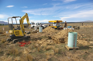
The map also revealed a general lack of knowledge about stony soils. To remedy this, Malcolm and other Hamilton-based colleagues went to Pukaki Airport in the heart of the Mackenzie Basin to collect cores from a series of sites that had stones at the surface, stones starting at 30 cm depth and stones starting at 50 cm depth. Four replicate undisturbed cores, 50cms in diameter and 70cms high, from each soil type were collected. These oil cores have now been transported to the laboratory in Hamilton in preparation for being irrigated with dairy shed effluent.
Malcolm says that with the spread of dairying to areas with poorer quality soils, such as the Mackenzie Basin, there is keen interest in the results of the research.
This work was funded by a FRST Sustaining Soil Services contract.
Further information:
Malcolm McLeod
Dung beetles to provide major farm management and environmental benefits
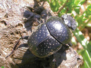 Farmers will soon have an unlikely ally in their efforts to improve environmental stewardship as Landcare Research is breeding colonies of exotic dung beetles for release. Improved soil health, reduced nitrous oxide emissions and improved pasture productivity are just some of the benefits provided by the beetles.
In February the Environmental Risk Management Authority (ERMA) approved the Dung Beetle Release Strategy Group’s application for the importation and release of 11 species of dung beetles in New Zealand. Staff at Landcare Research, which has been providing the science support for the group, travelled to Australia to collect specimens of two types of dung beetles that are now being bred in containment at Lincoln.
The beetles are being studied to ensure they are disease-free before MAF will give permission for their release, probably later this year. Landcare Research is also planning to import breeding stocks of further species from Australia, and others from South Africa and France.
Dung beetles search out the faeces of animals which they use for food and reproduction. Most adult dung beetles make tunnels in the soil beneath the faeces which they then bury to lay eggs in. Other species make balls from the faeces which they roll away and bury deep beneath the soil surface before adding an egg.
As the eggs hatch the grubs feed on the dung so they break it down and eventually turn it into a sawdust-like material that actually adds to the fertility of the soil structure while all the time getting rid of dung sitting on top of the ground.
Researchers Shaun Forgie and Hugh Gourlay say that while dung decomposes naturally, intensive farming means large amounts of dung are dropped which can lead to environmental problems such as leaching of nutrients into waterways and reduced pasture production because of increased forage fouling.
‘If we successfully introduce and establish exotic dung beetles in New Zealand we expect that in the long term there will be millions chewing and burying dung from pastoral animals such as cows and sheep and that means a monumental management change for our farmers,’ Mr Gourlay says.
That is because dung beetles have many potential environmental and economic benefits, says Dr Forgie.
- Improved soil health and reduced runoff. Increased aeration and water penetration into the soil, through beetle tunnels, reduces urine and liquid dung runoff, reducing microbial contamination, leachate pollution, and eutrophication of waterways;
- Likely contribution to reduced nitrous oxide emissions. Herbivore excreta account for 20% of New Zealand’s N2O emissions and 80% of the nitrogen content of dung is lost by volatilisation when dung remains on the pasture surface, compared to only 10% following burial by dung beetles;
- Greater pasture productivity. Stock will not graze around dung pats, reducing pasture productivity and burial of nutritious manure by dung beetles enhances grass growth, reducing reliance on fertiliser inputs. Solid fertiliser is one of the biggest working expenses on most conventional livestock farms;
- Reduced fly pests and human disease. Nuisance flies breed in dung but are outcompeted for resources by fast dung burying beetles. In Hawai’I, introduced dung beetles reduced dung breeding pest flies by as much as 95%;
- There will also be reduced infection by parasitic worms of livestock because dung burial removes the infective stages of parasitic worms of livestock. This would reduce the need and expense of drenching stock.
In the United States, which has 100 million cattle (New Zealand has ten million cattle) the services provided by dung beetles in removing cattle dung have been estimated to be worth US$380 million/yr to the US economy.
New Zealand lacks native pastoral dung-burying beetles. A tropical species Copris insertus was introduced in 1956 at Whangarei, and presumably due to poor climate matching, now has limited distribution North of Auckland. Two accidentally introduced Australian Onthophagus species are widespread, but have little impact, because they are small beetles that bury less dung, and don’t achieve sufficiently high densities in livestock dung.
Further information:
Shaun Forgie
Hugh Gourlay
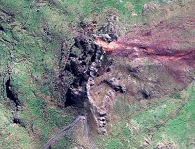
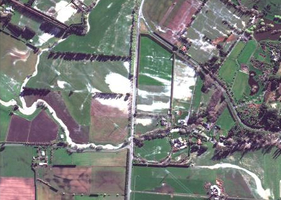
Enhanced satellite imagery – an eye in the sky following a disaster
Optical satellite imagery can now provide territorial authorities with high quality images of damage caused by a natural disaster.
Following Canterbury’s 4 September earthquake, Landcare Research processed high resolution images of the affected area (acquired by the Ministry of Civil Defence and Emergency Management with assistance from Ministry of Defence) for emergency response work.
Captured just hours after the early morning event, the high resolution (to half a metre) images showed features such as surface flooding, liquefaction, and major rockfalls.
Landcare Research Informatics Researcher, Stella Belliss says with the number of high resolution satellites now operating, imagery is available virtually daily, so can be captured on the next cloud-free day after an event.
“Our expertise is in taking that satellite footage from a range of sources, standardising or enhancing it – correcting the effects of slope, aspect, topography, and atmosphere – and quickly making it available,” says Stella.
“Following both major Canterbury earthquakes we took the raw imagery and orthorectified it (processed it so that it conformed to a map projection,) so that it could be used in the response teams’ Geographic Information systems, along with their other information layers, such as reticulated water or stormwater infrastructure.”
Landcare Research also has sophisticated digital image processing software to interpret information from the images, for example to map the total area of liquefaction in open spaces.
 |
 |
|
Rockfall damage at Castle Rock on the Port Hills (l), and flooding and liquefaction at Halswell were evident in Geoeye imagery provided to the New Zealand Government for response and recovery mapping. |
|
Following a 2004 storm in the lower North Island, Landcare Research was able to map 62,000 landslides for the Ministry of Civil Defence. The information was used to validate a regional model of landslide risk.
Use of the satellite imagery is not restricted to emergencies. Local and regional authorities have used Landcare Research remote sensing tools for recognising and calculating changes to a wide range of land features.
For the past decade, Stella and her colleagues have been mapping changes in the total area of impervious surfaces for the former Auckland City Council. Whenever an impervious surface such as a building or carpark replaces a permeable surface such as a grassed area or garden, stormwater loadings can increase. That research has shown the total area of impervious surfaces in Auckland City has increase by an average of 3-4% between 2000 and 2007, although individual territorial local authorities showed more increases, up to 13% in one area.
The imagery has been used to help regional authorities monitor changes in indigenous and exotic scrub cover, while mapping of the amount of Canterbury Plains farmland that is left fallow over winter has helped ECan better understand and manage nitrate leaching.
Other territorial authorities have saved hundreds of thousands of dollars in pest control monitoring by using Landcare Research’s enhanced satellite imagery of vegetation to gauge the effectiveness of possum control operations. Other projects have included the mapping of indigenous forest remnants, wetland status, riparian zones, and monitoring the condition of high country land.
Landcare Research is an agent for satellite operators from France, Japan, Canada and the United States, including NASA.
Further information:
Stella Belliss
Sustainable Development
Linking people with environmental initiatives
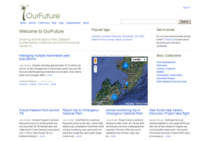 A new website has been developed that will help people learn about projects and activities throughout New Zealand that benefit the natural environment.
OurFuture is an interactive website that geo-tags sites of environmental projects and research onto Google Earth, and also uses photos and videos to tell stories about the work and its importance.
Landcare Research project manager Claire Mortimer says the website is designed to link people with environmental initiatives, and to make connections between research and work to sustain our natural environment.
“In this age of heightened environmental awareness many organisations including schools, community groups, environmental organisations and government agencies are undertaking successful initiatives and interesting environmental research,” she says.
“A lot of information is out there but it’s in many different places so Landcare Research is striving to make that information more accessible by developing the interactive website where any relevant organisation can publish information about their work improving our natural environment and resources.”
OurFuture has been developed and co-ordinated by Landcare Research in partnership with a range of organisations, seven of which are providing content at the time of launch: WWF-NZ, Forest and Bird, Hikurangi Foundation, Department of Conservation, Enviroschools, Bush Telly and QE11 National trust.
Claire is encouraging groups and organisations such as local and regional councils to join up to the website and learn how to upload stories of how their project or research is sustaining New Zealand’s environment.
Further information:
Claire Mortimer
Web: www.ourfuture.net.nz
Video introduction to OurFuture:
Please note: The newsletters are to keep territorial authorities informed about current research projects. The news items may include interim results that have not been peer reviewed. They should not be disseminated or quoted without first contacting the person mentioned at the end of each item.