Issue 5, October 2011
In this issue:
|
Editorial
I hope you enjoy this “bumper” issue of our council update. Every time we compile the newsletter we are aware that we are only presenting a slice of our work as there is always more that will be of relevance and assistance to councils around the country. We touch on some very different topics this time: the sustainability and economics of local food production, another exciting new bio-control, and a new project to develop a tool for Freshwater Invertebrate identification.
However, I know the one that many of you are waiting for is the arrival of S-Map OnLine website. This tool makes our extensive soil information more accessible as we use new database and visualisation technologies to present information in more intuitive and engaging ways. Also announced here are the next two versions of the Land Cover Database (LCDB), which some of you are involved with already. This will provide insights into the way land cover and land use is changing in this country.
There is a lot more soil-related news in our September edition of ‘Soil Horizons’ newsletter and the latest edition of our ‘What’s New in Biological Control of Weeds?’ newsletter is hot off the press as well.
If there’s a topic you would like to see in future issues, or if you have feedback on this issue, please do not hesitate to contact us.
Best wishes,
Christine Harper
Land Environments
Online access to soil information
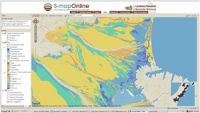 Landcare Research has unveiled a new online tool that helps people to better understand the soils that underpin New Zealand’s economy, land use and ecology.
S-map Online (http://smap.landcareresearch.co.nz) is a web browser service which provides easy access to information on the soils likely to be found at a location of interest.
It’s based on ‘Google Earth’ style navigation to make it easy to search, view and query, and allows a user to:
- explore interactive maps of soil properties such as soil drainage and available water;
- learn about the soil in their backyard or paddock;
- view detailed information about soil classes or attributes;
- create custom PDF soil maps for printing;
- for specific locations, download soil factsheets which provide more detailed knowledge of soil properties and information relevant to a variety of potential uses.
S-map Online is based on a digital soil spatial information system that is being populated with data to provide consistent and comprehensive national soil data layers to support applications at local, and regional to national scales. It improves on previous soil mapping, fills gaps with new mapping, and upgrades the associated soil property information to meet a new national standard.
Landcare Research’s Informatics Team Manager David Medyckyj-Scott says the launch of S-map Online is a “further step towards meeting the Government’s Declaration on Open and Transparent Government, and the requirement that data and information should be open and readily available”.
“A year ago today Landcare Research launched the LRIS portal, which gave those working in regional and central government, in industry, in research and in education access to environment data held by Landcare Research. Aimed at the professional data user, uptake of the service has been high and it is proving to be a great success. However, we felt there was a need for services which make data available in a much more user friendly and informative way and without the need to work with the data directly. So we are delighted to now be able to announce this new soils information service. ”
As well as access to detail soils information, the S-map Online web service has excellent, high quality base maps including maps based on LINZ topographic data. These allow the user to not only locate an area of interest with a high degree of accuracy but also provide a geographic context for the soils data.
Although S-map coverage is not yet complete, there is sufficient coverage to make the service a useful resource for many people. Work continues to extend S-map to the Environment Waikato and Environment Canterbury territorial areas, the soft-rock hill country in the central North Island and parts of Northland, Gisborne, Hawkes Bay, Manawatu, Wairarapa, Golden Bay and the West Coast.
“We also have plans to further develop S-map Online so users can develop their soil knowledge and ultimately make better informed and more reliable land use decisions and we’ll keep users informed of these developments,” says David.
During the initial period of operation, access to S-map Online outside of office hours is not guaranteed.
Further information:
About the service: David Medyckyj-Scott
About S-map: Allan Hewitt
Updated website to assess soil quality
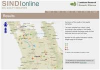 Landcare Research has updated its SINDI (Soil INDIcators) website (http://sindi.landcareresearch.co.nz) to help landowners and other decision makers assess and learn about soil quality.
Originally launched in 2000, SINDI helps people interpret a set of dynamic soil quality characteristics relating to the organic resources, fertility, acidity, and physical quality of a soil.
“The results help inform people about the general quality of their soil and suggest suitable management practices to remedy soil degradation,” says Landcare Research soil scientist, Dr Bryan Stevenson.
“We have now updated the site to make it more user friendly and interactive. People can compare their soil with information from our soils database, and see how their soil measures up against current understanding of optimal values. They can also learn about the effect each indicator has on soil quality and some general management practices that could be implemented to improve the soil.”
The updated site also has a link to the new S-map Online website. This means landowners can obtain additional soils information (soil maps and soil factsheets) for their area.
“In addition to updated information for landowners, regional councils can now use SINDI to generate soil quality statistics on a regional scale and display the data through a map interface. This will be useful for councils’ State of the Environment reporting.”
Underpinning the website is data from the approximately 1000 sampling sites across New Zealand. “Many of these sites have been resampled several times and the dataset from these resamplings represents a valuable resource to assess how our soils change over time,” says Bryan.
The update of the SINDI website was made possible through the New Zealand EnviroLink fund administered by the Ministry of Science and Innovation (MSI).
Further information:
Bryan Stevenson
New forest and shrubland classification system
 The monitoring and management of changing forest and shrubland in New Zealand will benefit from a comprehensive new classification system.
More than 70% of New Zealand’s forest and shrubland has been lost in the 800 years since human arrival through fire, land clearance and logging.
“Remaining forest and shrubland continues to be impacted, for example by invasive species and land-use change, so an up-to-date depiction of the composition, extent and structure of these woody communities, at a range of scales, is valuable,” says Project Leader, Dr Susan Wiser.
Landcare Research has used the LUCAS (New Zealand Land Use and Carbon Analysis System) plot network, established from 2002 to 2007 primarily to monitor carbon stocks, to reclassify our forest and shrubland cover.
Using the 1177 nationally representative vegetation plots (positioned on an 8km x 8km grid across the country), the researchers were able to identify 24 different broad vegetation classes termed ‘alliances’.
Each alliance was evident at between 19 and 105 plots, with each comprising an estimated land area of 144,000–794,000 ha.
“Stand structure data suggest that 16 of these alliances are largely stable whereas eight will undergo compositional change, so the new classification system will be valuable in managing that change,” says Susan.
“Previous classifications and vegetations maps, although based on the best information and analytical techniques available at the time, were either out-of-date, too broad, or didn’t accurately depict the actual vegetation.
“For example, in some areas the maps were largely dependent on aerial imagery, so they focused on canopy composition, or could not accurately distinguish between species such as the different beech (Nothafagus) varieties. From an applied perspective, this is important as Nothofagus now is the main indigenous New Zealand species managed for timber production in New Zealand. Landowners developing sustainable management plans, as required by law, need a framework to describe the specific type of Nothofagus forest they plan to manage, in a consistent way that can be readily placed in a national context.”
So what are the most obvious differences between the latest and previous classifications?
“Our new classification provides more differentiation of types in our most widely distributed forests and highlights the extent of alliances in disturbed landscapes, as well as those that are compositionally dynamic, and those invaded by exotic species. These are areas with high potential for future carbon sequestration and biodiversity enhancement, but still remain poorly understood.”
Work on the classification was funded by DOC, MAF’s Sustainable Farming Fund and Landcare Research internal funding.
Further information:
Susan Wiser
New databases to highlight land cover change
 How and where is land cover in New Zealand changing through time? What are the major characteristics of this change? These two key questions that will be answered by new editions of the New Zealand Land Cover Database (LCDB).
LCDB is a digital map of the surface of New Zealand created using satellite imagery. It contains detailed information on categories of land cover and boundaries, and is a record of land cover changes over time.
Two completed editions (LCDB1 and LCDB2), which show the state of New Zealand’s land cover in 1996-1997 and 2000-2001 respectively, have become critical to central, regional and local government, industry and research institutions. The information is used for land, water and biodiversity management, pest control and monitoring, wildfire threat and risk analysis, and environmental monitoring and reporting.
The creation of new land cover databases and related research has been identified as an important priority by Ministry for the Environment (MfE), Department of Conservation (DOC) and regional councils.
Landcare Research has been commissioned to deliver two further editions of LCDB and, a parallel research programme that will develop improved ways of generating land cover information.
The two new editions will leverage off the significant investment by MfE in research and imagery for their Land Use & Carbon Analysis System (LUCAS) programme. LCDB3 will be derived from the 2008 LUCAS satellite imagery and delivered in July 2012, while LCDB4 will use 2012 LUCAS imagery and will be delivered in July 2014.
“This project will answer key environmental research questions about how land cover is changing,” says Project Leader, Peter Newsome. “The research will also answer a number of other fundamental research questions about land cover classification.
“This research has spin-off benefits for other applications that require spatial analysis and classification of imagery – ranging from the monitoring of sustainable land use, habitat analysis, agricultural applications, economic modelling, to disaster response planning.
“Our goal is that by 2015 end-users will have access to a well established series of LCDB editions that provide the authoritative record of land cover and land cover change in New Zealand. These datasets will be widely used to support decisions on land utilisation, along with monitoring and reporting requirements.
“Landcare Research will also have an effective methodology and the experience and user support to take the series into the future as a leading edge land cover classification utilising the most appropriate satellite imagery available at the time.”
Peter says the project is collaborative, involving MfE, DoC, MAF and regional councils. “They will actively participate, contributing data and participating in specific activities, such as field verification.”
Governance and wider stakeholder advisory groups will be formed to guide future development of the LCDB and the research priorities required to deliver it.
The development of LCDB3 and LCDB4 is largely being funded by MSI and MfE, with support from DOC, MAF and regional councils.
Further information:
Peter Newsome
Water
Freshwater Invertebrate Identification and Information Resource - Online this Summer
Freshwater invertebrates are a useful measure of the state of our streams - but the identification and interpretation of the range of wee beasties found in any stream can be tricky.
Stephen Moore is something of a New Zealand (and international) “guru” on this topic and he has a wealth of knowledge and imagery which will help experts and beginners alike. To make this information (and the associated pictures) available to all, Stephen is developing a new on-line Freshwater Invertebrates Identification and Information Resource. This type of identification work can be undertaken by community and school groups and the resource is designed primarily for them (and to help councils when working with the community on their local streams). This project is funded by the Ministry for the Environment’s new Community Environment Fund, along with the Auckland Council and Taranaki Regional Council.
 |
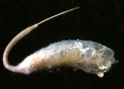
| Opposite ends of the pollution spectrum - Nesameletus mayflies (above) are found in streams with good water quality, while Syrphid maggots (below) thrive in grossly polluted waters. Images - Stephen Moore |
 |
The resource will be comprehensive, covering over 200 genera of freshwater invertebrates from all parts of the country, with high quality photographs of each group. Simple identification keys, combined with close-up images of diagnostic features, will help inexperienced (and experienced) biologists to correctly identify their stream specimens and to find out about the indicator value of each group.
Any aquatic invertebrate group found in New Zealand is highly likely to feature on the web resource. With an improved understanding of the stream invertebrate fauna and quality of the stream, community groups can make better decisions about whether their stream should be protected in its current high quality state, whether it could be a good candidate for riparian planting or whether the council pollution hotline should be called in to investigate.
Stephen has been analysing stream invertebrate samples from many parts of New Zealand over the past 25 years and he has built a collection of thousands of high resolution images of freshwater invertebrates. The resource will provide an “ask Stephen” facility for those needing further help such as identifying anything particularly odd in their samples.
The resource is expected to be online in January 2012 and questions in the meantime can be directed to Stephen.
Further information:
Stephen Moore
Biosecurity
Beating the beetle bug – new biocontrol agent for tradescantia
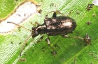 A frustrating two-year delay in releasing a biocontrol agent for one of New Zealand’s most widespread and problematic weeds, tradescantia (Tradescantia fluminensis), is now over.
Landcare Research got permission from ERMA to introduce the tradescantia leaf beetle (Neolema ogloblini) in New Zealand in 2008 but its release was delayed by the discovery of a gregarine gut parasite infecting the beetles held in containment.
For the past two years Landcare Research scientists have been working to eliminate the bug from the beetle populations.
Towards the end of last year three generations of gregarine-free beetles were achieved, resulting in MAF giving permission to release the beetles from containment.
Researchers beat the disease by adopting high levels of hygiene for adults and newly laid eggs, reducing the likelihood of infection, and low levels of hygiene for developing larvae kept in strict solitary confinement.
“By not keeping things too clean at this point any parasites that may be present are given the opportunity to build up to detectable levels in individual beetles, so we minimise the risk of failing to detect very low levels of infection,” says researcher Lindsay Smith.
“Any eggs or offspring from infected adult beetles can then be culled. All this information is recorded, e.g. we have full family trees for all of the leaf beetles and can trace each back to their great grandparents! This knowledge also helps us to reduce inbreeding by making selective crosses between different lines before release.”
Eighty pupae and adults were moved from Landcare Research’s containment facility at Lincoln to its Auckland site in late December. Mass rearing by Auckland staff led to the first release in an Auckland reserve recently. Widespread releases are planned for this spring.
As its name suggests, the tradescantia leaf beetle feeds on the foliage of the weed, which has become widespread in frost-free parts of the North Island and parts of the South Island. Thriving in shaded areas of gardens and bush, tradescantia grows densely on the ground preventing regeneration of desirable plants. Earlier research has shown that this weed is a threat to regeneration, and hence long-term survival, of indigenous forest in northern New Zealand.
Auckland Council recently gained ERMA approcal to release two further tradescantia agents that Landcare Research has been studying: the tip-feeding (Neolema abbreviata) and stem-boring (Lema basicostata) beetles.
Routine disease tests have found low levels of different species of gregarines in both beetle populations and Landcare Research is confident the methods used to rid the leaf beetle population of the parasite will also work for the stem-borer and tip-feeder beetles. Gregarine-free populations of both species should be available for release by the end of this year.
“We have pursued this trio despite the parasite problems because they attack different parts of the tradescantia plant (leaves, stem, stem-tips) and should make a complementary team,” says Lindsay.
“Defoliation experiments indicate that the sum effect of their feeding will be magnified in the presence of each other. Just wait until we get them out there!”
Meanwhile, work is continuing in Brazil with a fourth promising agent, the yellow leaf spot fungus (Kordyana brasiliense).
This project is funded by the Department of Conservation, National Biocontrol Collective and the Ministry of Science and Innovation under the Beating Weeds programme.
Further information:
Lindsay Smith
Sustainable Development
The vexed question of how to monitor plan outcomes: the Long Bay Structure Plan Monitoring Framework
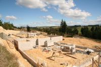
 Auckland’s Long Bay Structure Plan (LBSP) became operative earlier this month and is unique in its coverage of a wide range of sustainability issues across the four well-beings – social, cultural, environmental, and economic.
It integrates many innovative measures designed to require and support low impact urban design and development, while maintaining and enhancing the unique values of local streams, vegetation, coastal character, heritage, and marine environment.
Long Bay is an area of natural beauty with high recreational values, adjoining a marine reserve and a regional park, so it’s understandable that the many interacting resource management and sustainability issues over the range of rural and urban land uses and types of ownership have led to a high level of scrutiny in the environment court over more than 10 years.
The complexity of the LBSP land use strategy demands a high level of commitment from a range of stakeholders – with monitoring playing a key role in identifying if the policy and regulatory objectives are indeed being achieved.
Auckland Council saw the need to understand the effects of their plan and developments beyond the current monitoring and compliance requirements of resource consents and state-of-environment reporting and commissioned Landcare Research to lead the development of a monitoring framework.
We worked with Environment and Business Group and Planning Consultants Ltd to produce a framework that helps the council and other stakeholders check whether the structure plan is delivering the intended results. Long Bay provided the focus for the development of a robust methodology which can now be used by other Councils.
The resulting monitoring framework has six key steps which can be used to prepare a monitoring plan and to inform strategic policy evaluation.
- Issue prioritisation and selection (with the four well-beings in mind).
- Issue analysis to uncover drivers and impacts
- Information stocktake - gathering all stakeholders, data and indicators
- Outcome interpretation – using an “orders of outcomes” cascade to deal with complexity
- Indicator derivation and prioritisation – what new indicators will be useful and what can be monitored?
- Indicator specification – checking for ability to be consistent over time and through different organisations
A number of case studies in Long Bay were used to test the framework and they showed that it works well in practice across aspects of the plan including:-
- Heritage
- Earthworks and sediment control
- Streams and waterways
- and landscapes and coastal character
Monitoring is a key function of local authorities for operational and statutory requirements under the RMA, as well as to inform planning and decision-making. The integration of monitoring practices, data and indicators which may all have been developed for very specific purposes remains a challenge – one which this framework is intended to help resolve at a practical level.
Landcare Research is keen to see this work help councils when writing policy plans and considering how monitoring can be integrated, particularly when planning greenfield development. Seminars on the Evaluation and the Monitoring Framework for regional and local councils can be provided. Please contact Alison Greenaway to discuss specific requirements for evaluation and the potential for application of the framework.
Further information:
Alison Greenaway
Putting people and their behaviour into models of land use change
 Agent-based modelling (the integration of a realistic set of people and their behaviour within a model) has a lot to offer our understanding of changes in New Zealand’s land use.
Existing land use change models, both in New Zealand and abroad, have primarily focused on capturing the transitional possibilities and an understanding of the frequency in which these transitions occur. The role of individual actors within the land use and land cover change process is frequently abstracted or ignored. While removing people from land use change models simplifies a very complex system, the lack of insight into how actors might respond to policy, and/or shifting social norms limits the effectiveness of such an approach. In contrast, a model that does include people, their traits and behaviours would be better positioned to examine how effective a proposed policy would be in relation to land use change.
Two recent research projects have begun to examine the behavioural traits, types and responses of key actors within both urban and rural land use change.
Within the rural sector, agent-based models will enable us to better predict the land-use implications of policy and societal changes. Using existing information on farmer types, perceptions and motivations, researcher Fraser Morgan developed an applicable set of farmer agents and behaviours to explore how social changes (such as changes in the rates of succession); economic changes; and changes in their information networks, can result in spatial changes in land use.
This research project initially examined how farmers are categorised within the literature (with a key focus on Western farmers whose farming enterprises are run in a similar fashion to their New Zealand counterparts) with a focus on a future implementation within an agent-based model of rural land use & land cover change. To achieve this, the investigation has explored a range of existing approaches to categorising farmer types and behaviours; assessed areas which were lacking within the existing approaches; proposed a new typology for farmers within rural land use change models; and then proceeded to develop and implement the proposed approach within an abstract agent-based model.
Agent-based models have also been applied within an urban perspective where they examined another key agent within the process. While it is widely acknowledged that residential property developers are the most important agent in the urban development process, existing urban growth models often fail to examine the diversity of their types, strategies and behaviours and the resulting effects this differentiation has at a spatial level.
Fraser developed a spatial multi-agent model that accounted for the variation in how developers purchase and subdivide land. Using this model, two experiments were conducted that explored how the distribution of developer capital and the heterogeneity of developer behaviour affect the urban landscape. The research answered a range of theoretical and applied questions that highlight the importance of residential developers when examining the changes in urban growth and form.
Further information:
Fraser Morgan
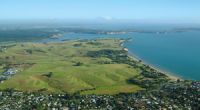
Rural Productive Potential in Greater Ōtaki
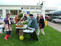 The production of food to supply the local population – and as an important element of the local and national economy - is a subject close to the heart of many New Zealanders. As a primary food producing nation, the decisions on land use are critical to our on-going ability to effectively nourish ourselves and to trade nationally and internationally.
Ōtaki on the Kāpiti Coast was known as the food bowl for Wellington, and good soils, a kind climate and enterprising farmers and market-gardeners developed a diverse range of businesses which delivered a variety of crops and produce – tomatoes, berry-fruit, greens, eggs and dairy to name just a few. With population spilling from the capital and the development of lifestyle blocks demand for land has recently driven prices beyond the ability of some traditional (and new innovative) farming and growing businesses to pay. While the additional population brings wealth and diversity to the area, the subdivision of productive land for housing and lifestyle blocks is of concern to many, including the Kapiti Coast District Council.
The council has a well articulated sustainability approach and is a leader in its support of low impact urban development, water use, and developing resilient responses to climate change. Taking a longer term view when developing the new District Plan, the council wanted to build a better understanding of the local food economy in Ōtaki, identify current and future environmental and economic issues, and ensure that planning decisions would protect future options for food production.
Landcare Research was contracted to undertake this work in 2010. The project reviewed both food production and food consumption to consider the destination of food produced in the area as well as the origin/sources of food consumed. Surveys, interviews and focus groups enabled the research team to build a picture of residents’ and growers’ / farmers’ aspirations about food systems – cultural, social, community, health and environmental well-being alongside the economic impacts. A wide range of secondary sources expanded that data and enabled comparisons with the rest of NZ.
Scenarios for different approaches to food production provided a way of looking at future options. Realising that it was unlikely that there would be consensus across the population, including those connected with food production, we took two strongly contrasting cases to help consider land use impacts and requirements across the entire spectrum. One scenario saw the development of a highly localised and diverse food basket, with an almost “self sufficient” focus on building community resilience – ideas propounded by groups such as Transition Towns, local iwi and growers who hope to set up an Ōtaki farmers market. The other scenario explored the land use, environmental and economic outcomes of focussing efforts on a national or international business based on a single product – we chose raspberries for this.
What we learned
 While people want to buy local product, price and convenience remain the most significant drivers in food choices. Many people look back fondly on the history of local market garden roadside stalls but now shop at the supermarket even for products which could be sourced locally as lack of time, and the convenience of one-stop-shop product variety determine food purchasing habits. Alongside this, we found that 82% of those surveyed grow some food for their own consumption. Locally produced, home prepared food is “fashionable” but not yet the dominant food paradigm and this is likely to be influenced by local product availability as much as by national and international trends.
Amongst growers, there is a high level of awareness of the environmental impacts of their decisions – about what to grow and how – but for many, market forces do not favour the options they would prefer. High volume, low value product (lettuces, winter greens) are particularly susceptible to the buying policies of supermarkets, and this has forced many growers to expand, amalgamate and move north to lower-priced land, or out of the business altogether. There is much interest in niche product opportunities, organics, and value-add – and several exemplar and award-winning businesses of these types in Greater Ōtaki. However, the economics of establishing and nurturing such a business means that many are funded by some or all of the family working in well paid jobs in Wellington. Both the individuals and the community at large recognise that this is unsustainable in the medium to longer term due to the time pressure placed on families and expense (and emissions) of commuting which negatively impact the ability to succeed in the land-based endeavour.
Due to the diverse nature of food growing businesses and evidence of the changing ways that local population wish to engage with local food, it is clear that the population of Ōtaki would prefer to protect their ability to feed themselves and/or use their land profitably. Engaging young people in food production – particularly building desirable employment in the sector – in parallel with the protection and enhancement of productive land - will be a key to delivering a sustainable long term food economy in Ōtaki.
Further information:
Christine Harper
Please note: The newsletters are to keep territorial authorities informed about current research projects. The news items may include interim results that have not been peer reviewed. They should not be disseminated or quoted without first contacting the person mentioned at the end of each item.