Proximal soil spectroscopy for soil C estimation and mapping
Soil samples in the New Zealand National Soil Archive are being scanned to collect visible-near infrared (Vis-NIR) soil spectra. The Archive contains approximately 25 000 soil samples, dating from 1939, and is housed near our Palmerston North site.
Soil Vis-NIR spectra provide a unique signature for each sample (Figure 1). We are developing chemometric methods to interpret accurately the spectra and extract information for soil moisture, C and N. A calibration set of spectra obtained from soils with known properties are needed to predict properties of unknown samples using their spectral signatures. The spectra can also be interpreted for a range of other soil properties, including clay content, mineralogy and soil function, for example denitrification potential and microbial C.
The aim of this spectral dataset is to provide a comprehensive spectral library for New Zealand soil spectra interpretation. We are also contributing our soil spectral library to a Global Soil Spectroscopy Group that intends to develop global calibrations for predicting soil properties. The Global library project aims to develop a global collaborative network for soil spectroscopy to further research and development and encourage its adoption in soil science.
Proximal Vis-NIR soil sensing is also being used to collect soil spectra from soil cores in the field at geo-referenced positions. Our research has found comparable accuracy for field-assessed soil C compared to that determined on spectra collected in the laboratory from air-dried, sieved samples. The denser sampling achievable by proximal sensing compared with conventional methods allows direct soil mapping and monitoring of soils using geostatistics.
Proximal soil spectroscopy with geostatistical interpretation of geo-referenced datasets will be used to improve our soil C mapping methods at the paddock scale, where spatial variability of soil C measurements has been found to vary largely over a distance of just a few metres (e.g. Figure 2). Spectral sampling position is targeted to sample the complete range of variability within the landscape, and the sampling strategy is determined from soil electrical conductivity and digital elevation maps obtained using on-the-go electromagnetic induction soil survey equipment.
Carolyn Hedley & Pierre Roudier
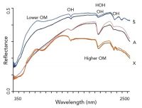
Figure 1. Soil spectra for Semi-arid (S), Allophanic (A) and Oxidic (X) Soils showing that soils with higher organic matter content exhibit less reflectance. The spectra also display the overriding effect of water (HOH) and hydroxyl bonds (OH).
![Figure 2. Soil electrical conductivity map showing soil C content [numbers on map] varying between 2.6% and 11.8% in a paddock where pine forest has recently been converted to pasture.](https://oldwww.landcareresearch.co.nz/__data/assets/image/0008/85373/varieties/thumb200.jpg)
Figure 2. Soil electrical conductivity map showing soil C content [numbers on map] varying between 2.6% and 11.8% in a paddock where pine forest has recently been converted to pasture.

![Figure 2. Soil electrical conductivity map showing soil C content [numbers on map] varying between 2.6% and 11.8% in a paddock where pine forest has recently been converted to pasture.](https://oldwww.landcareresearch.co.nz/__data/assets/image/0008/85373/19_spectroscopy_fig2.jpg)