Effects of mass-movement erosion
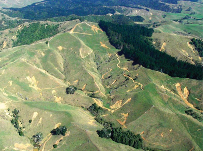
Shallow landslides affecting soil C stocks in hill country near Raglan.
The Soil Carbon Monitoring System (CMS) estimates soil C stocks for each land use in New Zealand to determine the effect of changes in land use on soil C. It is based on a model that combines soil C data from New Zealand soils with national spatial datasets of soil type, climate, land use, and slope to derive estimates of soil C stocks.
Early in the development of the CMS model it was recognised that it had several limitations, one of which was that it did not account for the effect of mass movement erosion on soil C stocks. The Ministry for the Environment recently engaged Landcare Research to define the most suitable approach to account for the effects of mass-movement erosion in the Soil CMS. Specifically we were asked to:
- define the land subject to mass-movement erosion to be recognised in the Soil CMS
- select a suitable approach to mapping that land and produce a map
- compare and evaluate approaches that account for the effects of mass-movement erosion on soil C stocks, and their change with change in land use, in the Soil CMS
- determine the most suitable approach, and develop an implementation plan.
Several approaches to defining the land subject to mass-movement erosion were explored, including actual and potential erosion recorded in the New Zealand Land Resource Inventory (LRI), erosion terrains, and the highly erodible land model. The definition of the land susceptible to mass-movement erosion affecting soil C stocks chosen was:
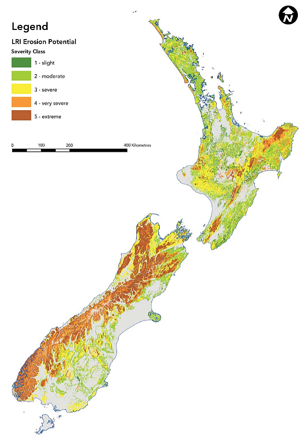
“all that land recorded in the New Zealand Land Resource Inventory survey with the following erosion types recorded as potential erosion: soil slip (Ss), earth slip (Es), gully (G), debris avalanche (Da), slump (Su), earthflow (Ef)”.
In total 7 853 461 ha of land in North Island have potential for some form of mass movement (69% of North Island), and 8 991 907 ha of the South Island (60% of the South Island) (Figure 1). Four possible approaches had previously been suggested to account for the effects of mass movement erosion on soil C stocks:
- Add land-use categories to encompass land subject to mass-movement erosion
- Sample eroded and uneroded land (on both grassland and forest land) to develop bias correction factors to apply to stock estimates
- Include a spatially continuous measure of mass-movement erosion risk as a factor in the Soil CMS model
- Sample areas subject to mass-movement erosion, stratified by land-use subcategory, to achieve proportional representation in the dataset.
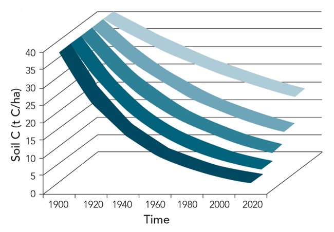
Each of these approaches has advantages and disadvantages and the choice of the preferred approach involved compromise and prioritisation in quantifying the major effects of erosion on soil C. All the proposed approaches have difficulty dealing with the effects of temporal changes in erosion. The recommended approach was to develop a set of time-dependent bias correction factors (Figure 2) that account for mass-movement effects that could be applied spatially to terrains of differing mass-movement erosion susceptibility and different land uses, within the framework of the Soil CMS and the LUCAS Calculation and Reporting Application. The approach will use a series of case studies examining existing erosion data where possible, and measuring soil C to complement the erosion data. Then effects of key processes (landslides, earthflows, and gullies) on soil C stocks can be incorporated into the Soil CMS model.
Les Basher
Figure 1. Potential mass movement erosion in New Zealand showing Land Resource Inventory (LRI) severity classes.

Figure 2. Theoretical landscape scale changes in soil C stocks between 1900 and 2020 on terrians of differing susceptibility to erosion, under constant land use.