Land Use - Data Federation
Land use is difficult to map as there is no single dataset that can easily describe how we use the land. We successfully reconstructed three national land use classifications (namely for PLUTs, LUNRZ, and LUNZ) by developing ways to record the workflow for the creation of a land use map.
Land use is a crucial input information for a variety of reasons. Our geospatial work to produce land use information was used for various projects, e.g. mapping the extent of artificial drainage in New Zealand, an MPI project on producing a framework for pasture quality and to provide advice around collating information on artificial drainage. We also worked in partnership with the Ministry for the Environment to explore various spatial layers and create a grassland classification layer for the Land Use Map in the LUCAS programme for greenhouse gas inventory reporting purposes.
We are now collaborating with Our Land and Water National Science Challenge to produce a land use map that will serve to estimate impacts of human activities on river water quality in the sources and flows programme.
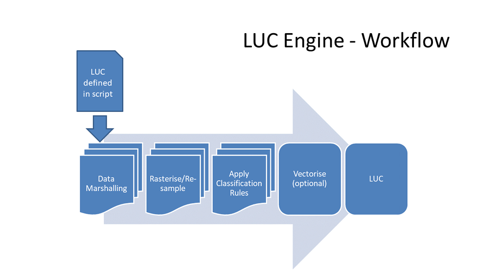
Because of the complexity of combining heterogeneous sources of information on land use or land cover, we developed a platform-independent technology, pyLUC, that enables automatic generation of LU classifications using the latest source data, to a high standard of reliability, and on demand according to end-user needs. pyLUC is a geospatial data-processing framework aimed at complementing standard geographic information system (GIS) tools to generate spatial land use classifications (LUCs) but with increased levels of transparency and repeatability.
pyLUC applies logic written in Python to existing spatial datasets to create new spatial datasets and automatically produces fine-grained provenance data exactly describing all sources and processing steps for the datasets produced (see Supporting IDA component for more information on pyluc and provenance). The idea is that anyone (with appropriate access permissions to the input datasets) can be handed a pyLUC definition script they can then use to reproduce the output dataset in full. pyLUC uses versioned input data available from authoritative instances on the Koordinates geospatial data warehouse platform, e.g. the LRIS Portal, increasing the transparency of the process, but can be extended to access data from other data source end points, e.g. geospatial web services.
Provenance capture was also retro-fitted in LUMASS (Land-Use Management Support System) and tested on an application of SedNetNZ.
The work on data provenance will be published in a forthcoming journal article.
The land use information created by IDA cannot be released for wider use because the data are derived from commercial input data.
References
Ausseil AG, Manderson A, Rutledge D, Wyman T 2015. Land use mapping review for Ministry for the Environment. Landcare Research Contract Report LC2356 for Ministry for the Environment.
Manderson AK, Jolly B, Ausseil A-GE 2018. Land Use Classification replicator.
Rutledge D, Manderson A, Lilburne L, Ausseil AG, Belliss S, Price R. 2016. Methodology for a GIS-based land-use map for Southland: a review. Landcare Research Report LC2491 for Environment Southland.