Research highlights
"On–the–go" mapping of soil water–holding capacity
Assessing environmental trade–offs between soil, carbon and water
Policymakers in the Ministry of Agriculture and Forestry (MAF) and regional councils need more sophisticated and integrated methods for assessing the environmental benefits of forests in terms of three important ecosystem services for New Zealand: climate change regulation, erosion control, and water provision. To help inform debate about the combined value of ecosystem services, we have developed national–scale models for forest growth rate, catchment water yield, and erosion rate as functions of forest cover, annual rainfall, and soil type.
The models are being used to generate maps of New Zealand showing economic value based on direct valuation of marginal benefi ts of land. In one simulation, eroded soil had an associated cost of $1.50 per cubic metre, water had an irrigation benefi t of $1 per cubic metre (where there is demand for irrigation), and sequestered carbon was assumed to have a market value of $73 per tonne.
The simulation showed the net benefit for planting trees was spatially variable and sometimes negative in water–short locations. The best places to plant trees would be in erosion–prone land in catchments with little high class land.
Increasing the effectiveness of the East Coast Forestry Scheme
A project, commissioned by MAF, examined erosion processes on soft rock hill country on the East Coast that has a history of severe gully erosion. Rivers, particularly in the Waipaoa catchment, carry huge sediment loads. Forestry has been the principal strategy for remediating gully erosion, but there was little in the way of quantifiable data.
By taking empirical data on gully shutdown through forestry, we were able to indicate how different reforestation strategies could affect gullying and hence sediment generation in the Gisborne District. Without historical afforestation in the Waipaoa catchment, sediment yields would have been 35% higher than at present. However, the research showed that considerable improvements could be made by more effectively prioritising
the most active gully systems for targeted planting. MAF staff were pleased to have quantitative data that reinforced the environmental importance and economic value of the East Coast Forestry Scheme.
Understanding the effect of soil erosion on carbon accounting
Soil is a major carbon sink, so erosion can have a significant effect on soil carbon. Rivers in the North Island may carry particularly high sediment loads, exporting an estimated 1.9 million tonnes of particulate organic carbon per year to the sea. Regenerating soils sequester an estimated 1.25 million tonnes of carbon per year from the atmosphere. These losses and gains have yet to be systematically measured but it is essential that they are incorporated within the New Zealand Carbon Monitoring System (CMS). We are working with the Ministry for the Environment (MfE) to review current erosion data and models, including the New Zealand Land Resource Inventory (NZLRI), to determine the best way of including the effects of mass movement (erosion) within the CMS. This work draws on our extensive capability in understanding and modelling of erosion processes and many years of developing nationally significant databases in the land resources area.
Understanding soil variability for irrigation efficiency gains
Presently, irrigation needs are usually based on regional evapotranspiration rates (water loss from soil and vegetation) with no allowances for soil differences. As a result, water may be wasted and the risk of water runoff and nutrient leaching increased within the over–irrigated parts of the field.
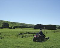
We have designed a new system to measure the soil’s water–status directly through sensors installed in the field so that variable–rate irrigators can deliver water to where it is needed, when it is needed – ´precision irrigation´. On–thego soil electromagnetic induction surveying enables us to map the soil’s available–water–holding capacity and delineate irrigation management zones, which are uploaded to the central controller of the automated variable–rate irrigation system. Wireless sensor networks monitor soil moisture in each of the management zones with data telemetered to a phone or computer advising when to turn an irrigator on or off, and how much water is needed.
We are continuing pilot trials (Canterbury, Manawatu and Ohakune) in collaboration with farmers, the Foundation for Arable Research (FAR), DairyNZ, Massey University, Precision Irrigation (the award–winning, Feilding–based company), and MAF’s Sustainable Farming Fund. Results indicate potential water savings of 9–26% – water that could be diverted elsewhere for improved water use efficiency.
Typically, for New Zealand, each millimetre of water saved for a 100–ha area reduces irrigation water application costs by about $200. Across the 750,000 ha of irrigated land in New Zealand, this amounts to $1.5 million (assuming average cost of irrigation is $2/mm/ha) and 7.5 million cubic metres of water saved.
Mapping irrigable land across New Zealand
We applied our modelling and spatial scaling expertise to produce a national map of irrigable land at a 5–km–grid resolution. This map (a data layer in geographic information systems) is based on resource consent data for Horizons, Hawke’s Bay, Wellington, Canterbury and Otago regional councils. Further work will produce a refined version based on remote sensing mapping. Both MAF Policy and regional councils have expressed strong interest in the data layer as it will help in assessing the current state of land under irrigation, and the potential for new irrigated land.
Improving water quality in iconic North Island lakes
We are assisting Environment Bay of Plenty to improve water quality in the iconic Rotorua Lakes, which are important to both tourism and local iwi. Our environmental economist and policy analysts provided a robust assessment of the value derived from different interventions, ranging from different land–use practices to regulation, for improving lake health. The analysis has been used as the basis for discussions with stakeholders and to help resolve the problem of eutrophication and pollution of the lakes.
While not as severely affected, the once pristine waters of Lake Taupo are also beginning to suffer from nutrient–laden runoff, largely from farms. During the year, we began another innovative project, led and funded by the Lake Taupo Protection Trust (LTPT), to assess the impact of cut–and–carry forage as a viable and flexible farming option to reduce nutrients in runoff. The project will be on an operational scale not used elsewhere in New Zealand or the world, and will use custom–built wick–activated lysimeters (in situ soil tanks) to collect leachate. The LTPT represents the broad community of farmers, landowners, Māori trusts and incorporations in the region.
The research data will provide essential refinements to the widely used, on–farm N–budgeting model Overseer®. Better understanding of forage regimes as part of N–budgeting will also be relevant to other regions where discharges from farming threaten water quality (e.g. Southland, Manawatu and Rotorua).
Rehabilitating mined land
We have provided research and advice on mine site rehabilitation for over 30 years. In 2009/10 this involved reviewing rehabilitation outcomes, helping design trials to develop new rehabilitation methods and developing protocols for rehabilitation to native ecosystems, farmland, and plantation forests, for coal and gold mines from Waikato to Westland and Southland.
Seeing mined land transformed from barren pits to living indigenous ecosystems and productive farms and forests can be inspirational. A continuing challenge is encouraging the collection and use of data to quantify progress towards mine closure.