Port Hills fires: satellite imagery
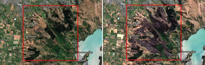
Following the Port Hills fires, Landcare Research quickly adapted and released a simple tool by which users could view the areas of the Port Hills affected by the fires that started on Monday 13 February.
The site uses pre and post-fire imagery taken by the Sentinel-2 satellite. This satellite has a 10-day orbital repeat and we were lucky to get cloud free images over the fire area on 3 of these - 25 January, 14 February, and 24 February. 4 February was cloudy.
If you are interested in the technology or how we visualised the imagery, please contact David Pairman pairmand@landcareresearch.co.nz for further information.