Impact 3.2: Land use options, asset management and other methods that increase carbon storage and mitigate greenhouse gas emissions are understood for environmental, economic and social benefits
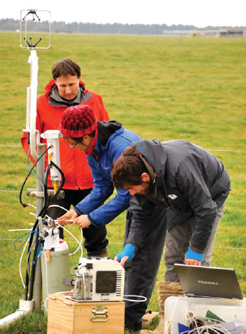
Setting up greenhouse gas sampling equipment. Image - John Hunt
Key performance indicator: Agricultural land managers and DOC are, where appropriate, using validated methodologies and land-use practices to mitigate greenhouse gas emissions and increase carbon storage and adapt to likely climate change effects.
Much of our research is focused on improving understanding of soil carbon in relation to land management and understanding the economic implications of managing land use to reduce emissions and enhance carbon sinks.
2010/11 Baseline situation: Models of carbon dynamics were largely inadequate for understanding wider implications of land use.
Progress 2011/12: |
Progress 2012/13: |
Progress 2013/14: |
| The effectiveness of the nitrification inhibitor DCD in reducing N2O emissions from stock effluent can now be optimised for use by agricultural land managers. | The agricultural sector has updatedinformation on the effectiveness of the urease inhibitor Agrotain in reducing NH3 emissions. | Natural Resources Sector policy officials can make use of our scenario modelling to better understand the costs, benefits and impacts of greenhouse gas emissions reduction targets for New Zealand. |
| Land managers have an improved basis for incorporating variability in carbon stocks when planning emissions management for natural forests. | Land management strategies and the National Greenhouse Gas Inventory benefit from new data on the long-term relative warming and cumulative effects of CO2, N2O and CH4 emissions attributed to land use change. | Land managers will benefit from innovative, cost-effective techniques to measure soil organic carbon at the paddock and farm scale. |
| National-scale indirect measures of the likelihood of, and average time taken for, gorse or broom to become ‘forest land’ could enhance assessment of eligibility for entry into the Emissions Trading Scheme. | Policy-makers, regulators and land managers have new information quantifying the effect of land use and land use change on soil carbon stocks. |
Highlights
Emissions reduction scenario modelling
Over 40 senior Natural Resources Sector policy officials attended our presentation on scenario modelling to support reductions in greenhouse gas emissions. We used three different economic models to assess 24 different policy scenarios that varied by reduction target, sectors covered and policy mechanism. The scenarios considered impacts on GDP, household income and trade. This modelling approach aids understanding of the costs, benefits and impacts as New Zealand considers target options for greenhouse gas emissions reduction in the lead-up to the UNFCCC Conference of Parties meeting in late 2015.
This work is part of the Enhancing Policy Development Portfolio, and is supported by MfE funding.
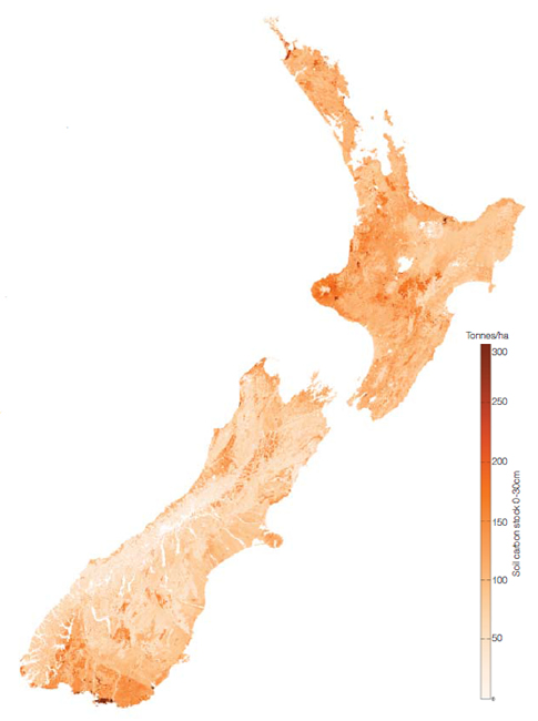
A national spatial model for soil carbon
Soil carbon is part of the life-support system of the soil. Soil disturbance, such as from tillage and erosion, may result in lost soil carbon; but other management factors such as revegetation and manure add carbon. These changes are small, which makes it hard to estimate the total carbon content of soil. Available data on soil carbon content are patchy; some areas are well covered by field measurements while other regions and soil types are relatively sparse in coverage, adding a degree of uncertainty to information in those localities.
In collaboration with AgResearch, we built a model that can estimate the total soil carbon content for every location over the landscape. The model also generates the level of confidence for the estimates – the range of values within which the actual value will be, given a particular set of climate, terrain, and other landscape conditions. Confidence estimates are important for agricultural and climate change models that rely on these soil carbon estimates. This model is currently being used in a collaborative project we are undertaking with the University of Sydney to develop fine-spatial-scale models of soil carbon; this work is funded under the Global Research Alliance (GRA). The model has potential to be used by other GRA countries in future, particularly where soil carbon is required as an input to ecosystem models.
This research is part of the Measuring Greenhouse Gases and Carbon Portfolio, and was supported by the NZAGRC.
Farm-scale measurement of soil organic carbon stocks
Farmers want to monitor the soil organic carbon stocks on their properties for various reasons. These include carbon farming initiatives, carbon accounting exercises and assessing soil quality over time. Therefore, we are developing a farm-scale method to assess soil carbon stocks. We are using the NZAGRC national soil carbon model (described above) to derive baseline values for a property. We then use finer scale environmental data to apportion the baseline value within the property boundary.
The finer scale environmental data that we are using includes EM (electromagnetic) and elevation data. Airborne LiDAR surveys provide very accurate elevation data, typically at one-square-metre resolution, and we obtain further attribute data layers from the digital elevation map; these include slope, aspect, wetness and radiation incidence. These attributes relate to organic matter accumulation and decomposition and improve the performance of the spatial model predicting soil carbon stocks.
A statistical analysis of the spatial layers is used to decide on soil sampling positions. Soils are scanned in the field at these positions using Vis-NIR spectroscopy. This is a cost-effective approach allowing more geo-referenced soil carbon values to be determined for the same cost as traditional lab analytical methods. The method scans soil cores at 1-cm intervals, improving depth resolution and detecting subtle but important changes that may occur centimetre by centimetre down the soil profi le. This will help improve our understanding of soil processes at resolutions that are largely impractical using standard laboratory methods. While it is being developed for soil organic carbon, the method can also be applied to mapping other soil attributes, such as texture and moisture.
This research is part of the Measuring Greenhouse Gas and Carbon Storage Portfolio, and is supported by MPI and GRA funding.
Potential for carbon farming in Gisborne–East Cape
We worked with Motu Economic and Public Policy Research and overseas colleagues to construct a spatial model to evaluate the potential scale and location of carbon farming in the Gisborne – East Cape District. This model assessed carbon accumulation, economic value, andpotential uptake of a carbon farming management system that utilised mānuka regeneration on set-aside land.
The study estimated that, economically, reforestation could out-compete grazing on at least 27% of eligible land in the Gisborne District. Potentially Kyoto-eligible regrowth of native forest species on 379,000 ha of marginal pasture could store 104.21 Mt CO2-e over 70 years. Furthermore the most conservative scenario indicated that promoting carbon farming across nearly 103,000 ha of this land could generate approximately NZ$912 million in excess of expected grazing revenues over the next 70 years.
Additional sensitivity analysis showed that uncertainty about the scale of carbon sequestration can have a sizeable effect on the estimated profitability of carbon farming, and that estimated land conversion is strongly affected by the choice of discount rates (i.e. the weight that future revenues and costs are valued at today). The amount of land that could be converted was also affected by the ability for farmers to benefit from compatible incentives for other ecosystem services such as honey production and payments from the East Coast Forestry Programme for planting on highly erodible land. Furthermore, the expected profits from carbon farming are strongly affected by the uncertainty of the future value of carbon credits.
This research is part of the Enhancing Policy Development Portfolio, and was supported by the Tindall Foundation, the National Science Foundation (USA) and MPI’s Sustainable Farming Fund.
The effect of land use on soil carbon
Landcare Research, in collaboration with the University of Waikato, has continued to make good progress in improving understanding of what effect different land uses have on soil carbon stocks and fluxes. The work is part of the Understanding Ecosystem Services and Measuring Greenhouse Gases and Carbon Storage Portfolios.
Land conversion to dairying
Where plantation pine forest had been converted to dairy pasture in the Central North Island, sampling along a time sequence of soils showed that soil carbon stocks either increased or there was no significant change. Given the large areas of pine plantations converted to dairying across the region in recent years, this research will improve New Zealand’s international carbon accounting, and suggests that accumulation of soil carbon may partially offset the loss of carbon from forest removal. However, an aligned study indicated that nitrogen losses (e.g. via leaching or gaseouspathways such as N2O) had likely increased. An increase in N2O emissions would offset any increase in soil carbon.
This research was supported by MBIE Core funding, Dairy NZ, and the Wilf and Ruth Malcolm Postgraduate Scholarship (University of Waikato).
Long-term carbon changes in pastoral soils
 Resampling soils at 125 flat-to-rolling pastoral sites throughout New Zealand revealed, on average across all sites, a significant decline in soil carbon (8.2 tonnes C per hectare) over roughly 30 years from 1980 to 2010. Interestingly, this average loss was driven by a significant decrease of carbon in gley and allophanic soils, with no significant C-change in any other soil orders. The same study reported significant soil-C increases across 23 hill country sites. Because hill country pastures occupy a large proportion of New Zealand’s total pastoral area, at the national scale it was estimated that there would be a net increase in carbon in pastoral soils (although uncertainty around this estimate was high). Further research is investigating why carbon is increasing in some soils and decreasing in others, with particular interest in why allophanic soils are losing soil-C. These soils contain large quantities of carbon, which was previously thought to be stable.
This research was supported by MPI funding.
Managing carbon in pastoral soils
In addition to soil-sampling-based studies (which can reveal ‘decade-scale’ changes in soil carbon), we have also been making continuous CO2 emissions measurements over grazed dairy pastures at farm scales (partly funded by the NZAGRC). Such measurements allow us to identify how specific management and climatic events affect the carbon balance of pastoral systems. Using these techniques, we were able to quantify carbon losses following cultivation, and identified that the length of time soils are left unvegetated and soil moisture are key determinants of the net amount of carbon lost during cultivation. Based on this, we were able to make a clear recommendation toland managers that re-grassing in late summer/autumn, and minimising the period between spraying and seeding of new pastures, should reduce losses of soil-C. Results also suggest that occasional cultivation (e.g. ~every 10 years) for pasture renewal is unlikely to cause a long-term decline in soil-C, because carbon lost during cultivation will probably be regained later in the year. Ongoing work is investigating whether re-grassing to ‘more diverse’ pastures (e.g. containing chicory and plantain) increases soil-C sequestration, and quantifying the full greenhouse gas balance of irrigated dairy and adjacent dryland pasture systems.
This research was supported by NZAGRC and the University of Waikato.