Use of nationally significant databases & collections: 2014/15
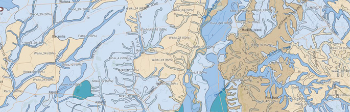
S-map Online showing drainage classes for an area of Southland.
Landcare Research is committed to ensuring our nationally-significant databases and collections and associated services are readily available and can be used efficiently and effectively.
Plant communities
Descriptions of vegetation communities in permanently or temporarily marked plots continued to be in demand and to contribute to international research (see: Measuring biodiversity change)
National Vegetation Survey databank
- 5208 data sets supplied to 35 users (100% service delivery)
- A new remote access service was released to MfE users so that they can view LUCAS (Land Use and Carbon Analysis System) data within NVS to aid international carbon reporting obligations
- Significant resources went into processing many boxes of hard-copy records resulting in 83 new projects being incorporated and available in NVS
- The data entry and management tool used by DOC for Tier 1 monitoring purposes was updated
Biological collections
We continued efforts to increase the value of and services from the biological collections and databases. (see: Defining land biota).
New Zealand Flax Collection (Living Plants)
- 20 sets of divisions supplied, 10 enquiries (100% service delivery)
- 53 visitors
- Information and images of the Orchiston Collection and some of the Offshore Island Collection harakeke plants are now in NatureWatch NZ
- The harakeke collection is part of a National Library and DigitalNZ initiative aimed at making digital content easy to find, share and use
Nga Tipu Whakoranga Ethnobotany Database
- 55,861 page views
- 16,297 visitors
- Technical updates have improved the display of information
- 1280 specimens loaned, 65 transactions (100% service delivery)
- 686 identification and taxa enquiries
- 240 visitors to the collection
- The Cotoneaster identification key was updated with new information, new images, revised descriptions, and nomenclature; the key is important to biosecurity managers
- The online key to Coprosma was also launched as an app for smart phones and tablets
- >5000 images of diagnostic characters of weeds and native flowering plants were made available in the Image Gallery of the eFlora
- A new service notifies DOC, MPI and other users of recent name changes in the Plant Names Database
New Zealand Fungal Herbarium (PDD)
- 36 requests responded to (100% service delivery)
- 325 specimens loaned, 26 transactions
- 1176 identification and taxa enquiries
- 163 visitors to the collection
- Identification keys and diagnostic images prepared for over 140 described and undescribed fungal taxa are being tested by the Fungal Network of New Zealand and NatureWatch NZ
International Collection of Microorganisms from Plants (ICMP)
- 643 cultured strains provided, 117 orders (100% service delivery)
- 450 identification enquiries
- 163 visitors
- ICMP and PDD are part of an international project of developing an authentic dataset of DNA sequences from fungal type specimens. Fungal identifications are now routinely based on a comparison of DNA sequences derived from cultures, dried specimens and from samples.
- Taxonomic updates from national and international research are made available to MPI and EPA via the New Zealand Fungi and Bacteria (NZFUNGI)database
New Zealand Arthropod Collection (NZAC)
- 52 loan requests (96% serviced), 1425 specimens loaned
- 443 identification and taxa enquiries
- 105 visitors
- 13 online publications that include taxonomic keys of value to biodiversity and biosecurity users as well as the broader scientific community
- 1099 records added to the NZAC names data base (updates mainly for Lepidoptera and Coleoptera)
Land and soils
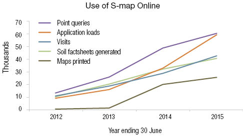
Land Resource Information Systems (LRIS) Portal and S-map Online continued to increase their value to the wider agricultural and environmental community (see: Characterising Land Resources).
Land Resource Information Systems
- 24,408 visits
- 3919 users
- 4,936 data downloads
- 42,713 visits
- 40,660 soil factsheets generated
- 2574 maps printed
- 59,279 application loans
- 60,432 point queries