Convenient access to Māori land information
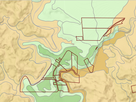
Map generated by the land visualisation tool with a land capability overlay that shows the general capability and versatility of the land.
Landcare Research has developed a Māori land visualisation tool online. The work began in mid-2009 and was funded by Te Puni Kōkiri (Ministry of Māori Development).
The new tool, which combines updated Māori land block data (property and legal) from the Ministry of Justice (Māori land online) with environmental and land resource data from Landcare Research, has been designed specifically for Māori land owners and land managers searching for their land blocks, and wanting to know about the land resource characteristics of the land and its potential. The tool, however, is available to everyone who has an interest in Māori land.
The website can create a custom report of the environmental characteristics for any Māori land block in New Zealand. Māori land can be located by using either an interactive map or by searching for a block name or place name. The tool generates a series of resource maps, statistics, and descriptive information detailing land resource information and presents this to the user as an interactive webpage. To date, underlying data have been derived from two nationally significant databases, the New Zealand Land Resource Inventory (NZLRI) and the National Soils Database (NSD).
The data, displayed over topographic maps, satellite imagery, and aerial photographs, provide convenient access to extensive information about Māori land. This information assists Māori land owners to access and visualise environmental data in relation to four questions:
- Where is my land? This enables the user to see the location of their land on an interactive map that also shows the size of the land holding, the number of owners, and who manages the land (e.g. a trust).
- What does it look like? The user can view a satellite image of their land, land-use capability and soils information.
- What is around me? This shows what geographic features, infrastructure, other land blocks, etc., are on and around their land.
- What can I do with it? This indicates land-use potential, i.e. whether it is suitable for cropping, horticulture, forestry, etc.
The tool has been shown at conferences and workshops and generated considerable interest around the country, especially from Māori landowners and organisations such as trusts and incorporations, as well as many Government departments. Māori have been waiting a long time to gain better and easy access to land resource and environmental data of their blocks. In future Māori land data can be linked to relevant data from many other sources. We have already linked the Māori visualisation tool to the National Library’s DigitalNZ records, providing a wealth of historic and archival information for each Māori land block.
Garth Harmsworth & Marino Tahi — Landcare Research