Meeting the demand for quality soil information to underpin critical decision making
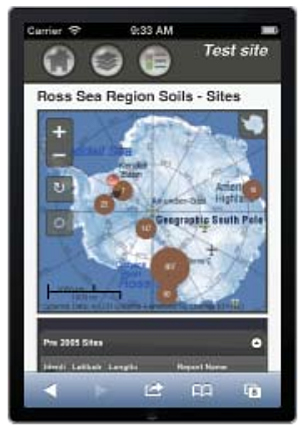
Soil mobile app displaying the Antarctica Soil Database.
Data that characterise land resources are fundamental to improving both agricultural productivity and environmental quality. Knowing the spatial variability in how much water soils can store has a significant impact on the water-use efficiency of irrigation developments.
Soils also vary greatly in their natural abilities to buffer and filter contaminants, and the value of accurate and accessible soil information has heightened as the need to manage the impacts of intensive land use on fresh water has become a national priority.
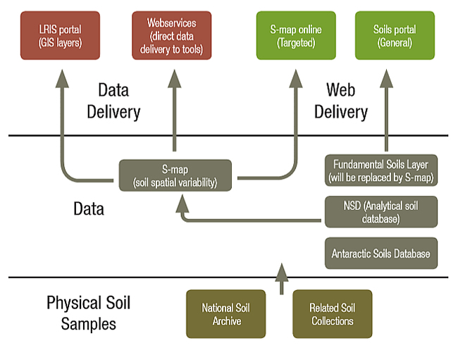
Landcare Research is custodian of the National Soils Database (NSD), the S-map soil survey database, and the National Soil Archive. The NSD stores analytical measurements and their meta-data for a wide spectrum of New Zealand’s soils. This database is supported by the National Soil Archive, which is where physical samples from key soils are stored for future analysis. S-map is building a national soil survey database of the spatial variability of New Zealand’s soils, drawing on the underpinning NSD to link analytical data to areas of the landscape with similar soil properties. The greater accuracy, richer information, and flexibility of the S-map system provide significant advantages over the coarser-resolution national-scale fundamental soil layers, which were derived from the Land Resource Inventory (LRI). Figure 1 shows the relationships between our soils datasets, and the services we provide to supply this information to users. We highlight key initiatives that are underway regarding these nationally significant databases. Thanks to Regional Council support, the coverage of S-map increases incrementally every year, focussed at this stage on the land with potential for intensive land use (generally <15° slope). Last year S-map extended to include new areas in the Gisborne, Waikato, Canterbury, Auckland, Hawkes Bay, Bay of Plenty, and West Coast regions. Work continues in most of these regions, and also in large areas of Southland and Otago. Further progress in S-map coverage depends on the availability of funding.
Use of the S-map Online web service continues to grow highlighting the strong demand for quality and accessible soil information. The popular soil fact sheets, available for each soil through S-map Online, provide detailed soil data specific to land management tools such as Overseer and the Dairy Effluent Storage Calculator. Landcare Research continues to develop the delivery services for our soil information, with research this year focussing on development of an ‘interoperability system’ to enable soil data to be streamed directly from the S-map database into an end-user tool, with the first application being to link S-map to the Overseer model.
To support upcoming farm management environment plans we have added soil vulnerability assessments for nitrate and phosphorous contamination. Improved models have been developed to predict key soil physical properties, including important soil water storage attributes. These new hydrological pedo-transfer functions (generalised linear models) are based on a wider range of data, including percentage of sand, silt and clay, soil classification, soil parent material, and characteristics of the functional horizons (topsoil vs subsoil, stone content, structure size, and consistence classes). This has resulted in changes to estimates of profile available water, particularly for Pumice soils.
National Soils Database (NSD)
Underpinning the soil information provided in the S-map fact sheets are the analytical data stored in the National Soils Database (NSD). This year Landcare Research has renewed investment in the NSD to modernise the design of the database and migrate the data from the existing NSD to a new database technology. At the same time we will enhance our capability to identify, capture, and store key new analytical data as they are generated. Over time the vision is to provide a repository for a range of publicly funded soil analytical data, enabling integration of data from a myriad of projects into a standard format that is readily accessible for re-use in future applications.
Soils Portal
During the winter we also upgraded the Landcare Research Soils portal, which provides access to maps and information on the New Zealand Soil Classification, the New Zealand NSD and Ross Sea Region soil sites, and the 16 class attributes from the Fundamental Soils Layers. During the re-engineering we created a version of the site that would work on mobile devices such as cell phones and tablets. This is available for testing at Landcare Research's mobile soils app (beta).
Sam Carrick — Landcare Research