A new spatial model for New Zealand soil carbon
Soil carbon is part of the life support system of the soil, and it is widely accepted that carbon content is a major factor in the overall health of soil. We know that humans increasingly influence the amount of carbon in the soil, through losses induced, for example, by tillage and erosion, and gains sustained by revegetation and adding manure.
The amount of carbon in soil is important for models in agriculture, as well as for components of global climate models. Landcare Research and AgResearch have recently completed a project that sought to build a model that estimates the total carbon content in the soil for every location over the landscape, as well as the uncertainty in the estimates (Figure 1).
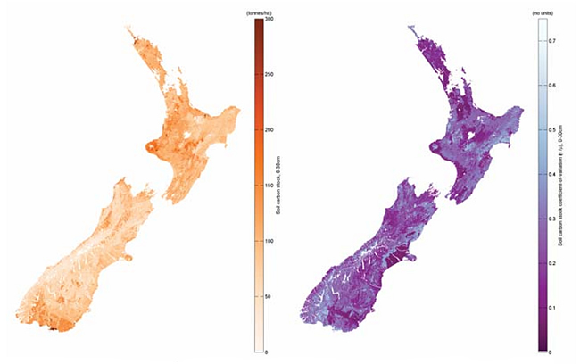 |
| Figure 1. (Left) Soil carbon stock (0–30 cm layer), in tonnes/ha; (Right) Relative accuracy of the soil carbon stock estimate (standard error/mean). |
To build the model, the researchers assembled all the major soil carbon data sources from New Zealand, as well as a range of map layers thought to be associated with soil carbon. These layers describe climate and terrain, as well as soil and landscape. The aim was that the map layers could be used along with the soil carbon sample data to build a model that describes soil carbon in terms of the various map layers. It would then be possible to estimate soil carbon over the landscape using the collection of layers.
There are several problems with this conceptually simple approach. First, the large number of map layers available for use as predictors, as well as their possible interactions, makes the problem of finding the “best” selection of predictors very difficult. Second, available soil data are patchy; some areas are well covered by field measurements while other regions and soil types are relatively sparse in coverage. The disparity in sampling over the landscape causes problems in building a model for soil carbon, especially in respect of the uncertainty.
The researchers used a method from data mining (“boosting”) to find out the best set of map layers to predict soil carbon. Boosting is a method that can readily accept a large number of potential predictors of soil carbon, testing each predictor and their interaction in a systematic manner. Boosting has some disadvantages, however; the method can be quite slow and provides a model that is difficult to interpret. So the result from data mining was used as a starting point for a conventional statistical model-building exercise, but it was a crucial step that drastically reduced the time taken to develop the final model for soil carbon.
A critical step in the research was the development of a model for the uncertainty of the soil carbon estimates, which is the range of soil carbon values within which one might find the “true” value of soil carbon, given some set of climate, terrain, and other landscape conditions. Model uncertainty is essential if the uncertainty or confidence estimates are needed in downstream agricultural and climate change models.
This work was funded by the New Zealand Agriculture and Greenhouse Research Centre (NZAGRC), and involved Dr Stephen McNeill, Dr Allan Hewitt (Landcare Research), and Dr Andrew Manderson (AgResearch).
Stephen McNeill — Landcare Research