Measuring bank erosion using historical aerial photography and LiDAR
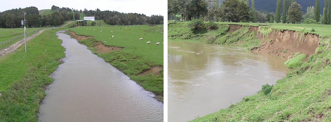
Bank erosion. Image - Les Basher
Introduction
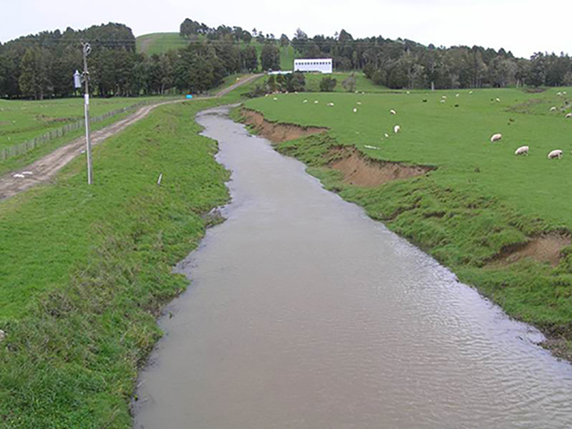
Bank erosion (Fig. 1) is commonly perceived as a significant contributor to river sediment loads but there are few measurements to quantify bank erosion rates. Landcare Research scientists have studied river bank erosion in the Kaipara Catchment in Northland to better understand the sediment dynamics of rivers and measure lateral migration of meandering channels. The extent of bank erosion is a function of multiple controlling factors such as storm and flood events, riparian vegetation, adjacent land use, bank material composition, and topography.
This work contributes to the collection of detailed data to improve SedNetNZ, a sediment budget model being developed by Landcare Research (see Soil Horizons issue 24, December 2015), which includes bank erosion as a core component.
Methods
We measured bank erosion for four different river reaches (Wairua, Mangakahia, Tangowahine, and Hoteo Rivers) with average lengths of 11 km, as well as one smaller (3 km long) reach of a tributary to the Tangowahine River. River bank positions were mapped using historical and modern aerial photography and a LiDAR-derived digital elevation model. We also used the LiDAR data to measure the height of river banks every two metres along both sides of the river channels. The results were in the form of polygons signifying either areas of erosion or accretion (deposition) which were combined with local bank height to calculate volumetric erosion and accretion rates.
Results
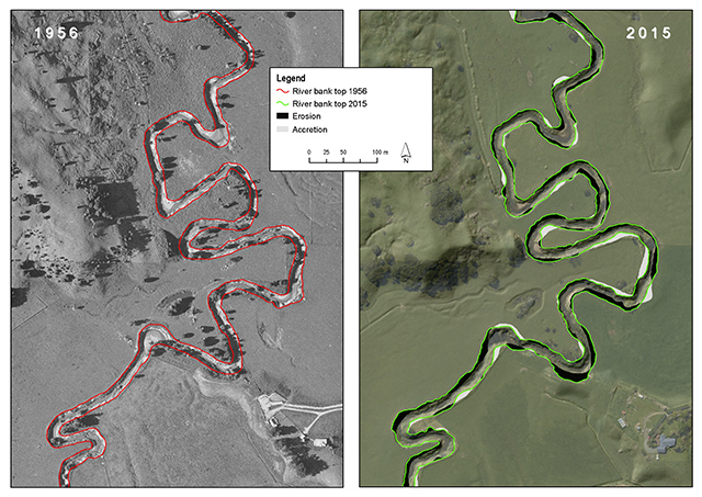
An example of the mapping is shown in Figure 2. Erosion rates varied widely but were usually greatest on the outside of river bends, particularly downstream of the apex of bends. Sites of accretion typically, but not always, occurred on the inside of bends and were frequently greatest upstream of the apex of inside bends. Straight stretches tended to alternate between erosion and accretion and were generally evenly balanced – in some instances with long stretches of erosion countered by similar stretches of accretion on the opposite bank. However, bank migration rates along straight stretches were not as significant as along river bends.
The average lateral migration of eroding banks for the Wairua and Mangakahia Rivers was found to be –0.139 m/year and –0.210 m/year respectively, with average lateral accretion rates of 0.165 m/year and 0.239 m/year (see Table 1; negative values denote erosion, positive values accretion). These rates are comparable to other measurements of bank migration obtained elsewhere in New Zealand, for example in the Waipaoa River, measured in 2011 by scientists Ron De Rose and Les Basher. Changes in bank height along a river reach can have significant influence on volumetric calculations and underlines the value of volumetric measurements of bank migration over planimetric measurements alone (as given above). The volumetric erosion rates for the Wairua and Mangakahia Rivers are –0.027 and –0.126 m3 per metre of river length per year respectively for the entire period of analysis. Rates of erosion and accretion can be quite different for each of the 4–5 periods assessed. Overall, the results reveal a relatively even balance between erosion and accretion at all sites over the entire period.
Table 1: Channel characteristics and bank migration rates for the five study sites
| Study Site | Wairua River | Mangakahia River | Tangowahine Tributary | Tangowahine River | Hoteo River |
|---|---|---|---|---|---|
| Period | 1960–2015 | 1961–2015 | 1961–2015 | 1956–2015 | 1960–2012 |
| Average bank height (m) | 2.9 | 4.5 | 1.2 | 3.1 | 4.9 |
| Average channel width (m) | 17.0 | 19.7 | 2.6 | 4.8 | 15.6 |
| Sum of erosion (m3) | 188,800 | 576,900 | 28,200 | 492,000 | 421,600 |
| Sum of accretion (m3) | 178,700 | 509,200 | 29,800 | 364,200 | 462,900 |
| Average lateral migration (m/yr) at sites of erosion | –0.139 | –0.210 | –0.158 | –0.144 | –0.123 |
| Average lateral migration (m/yr) at sites of accretion | 0.165 | 0.239 | 0.177 | 0.146 | 0.125 |
| Average migration rate (m/yr) | 0.017 | 0.021 | 0.010 | –0.009 | 0.010 |
| Average volumetric migration rate (m3/m/yr) | –0.027 | –0.126 | 0.010 | –0.161 | 0.059 |
This study has provided detailed volumetric data on bank erosion for a number of periods over the past 60 years to help unravel the amount of sediment removed from a reach as well as that redeposited. To improve the bank erosion component of SedNetNZ, Landcare Research aims to collect additional bank erosion data from a diverse range of reaches and styles of river. These data will support the development of relationships between discharge variables, catchment characteristics, morphological characteristics of streams, and bank migration rates.
Acknowledgement: This work was supported by the Ministry of Business Innovation and Employment under contract number C10X1006 for the Clean Water Productive Land research programme.
RAPHAEL SPIEKERMANN, HARLEY BETTS AND LES BASHER – LANDCARE RESEARCH
E: spiekermannr@landcareresearch.co.nz
Figure 1: Photos show typical erosion processes at the Mangakahia River site. © Les Basher
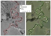
Figure 2: An example taken from the Tangowahine River shows the river planforms mapped using historical aerial photography (1956) and recent imagery (2015). The bank migration during this period (1956–2015 is displayed as areas of erosion and accretion in the 2015 map.