Land water connections
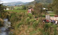
Management of the Sherry River being discussed on an ICM Motueka field trip for New Zealand and Chilean visitors
Soil, land and water – these finite resources directly underpin our economy and provide services of immense environmental, social and cultural value. With good stewardship of these resources, New Zealand will have a healthy future. Science has an important role in assuring this future.
While our databases of nationally significant resources provide excellent documentation of our land resources (what is found where), interpreting the opportunities and risks is considerably more complex. Digital initiatives, such as S–map, and sophisticated process models are clarifying the links between soils, land and water.
Saving Water by Precision Irrigation
Since the 1960s, the amount of irrigated land in New Zealand has more than doubled every decade. The relatively recent intensified land use for dairying has seen water demands surge to potentially unsustainable and hence highly controversial levels. While centre–pivot systems provide the most efficient blanket–coverage, they represent a fraction of the efficiency that could be achieved with precision irrigation, especially where variant soils exist under one irrigation system.
We have developed a sensor and GPS system to map soil variability and define management zones based on the capacity of the soil to hold plant–available water. Soil moisture information is logged hourly and transmitted wirelessly to the farm office. This ensures the required amount of water – no more, no less – is delivered to each of the soil zones, improving water–use efficiency and reducing pumping costs while maintaining maximum crop yield.
Modelling Nitrate Leaching to Aquifers
Nitrate discharge to groundwater from agricultural and irrigation practices is an issue that threatens water quality of aquifers under the Canterbury Plains. We completed modelling of several land use and aquifer scenarios for ECan as part of their Water Management Strategy study. Knowledge of irrigation patterns is critical for assessing nitrate leaching but had proved difficult to interpret from available sources. Using satellite imagery at multiple dates, we developed new methodology to map areas likely to be irrigated.
We also significantly extended the AquiferSim model, previously developed with our partners, to produce horizontal–layer maps of nitrate contamination (before only vertical profiles were possible). It can now model complete groundwater catchments (i.e. where water enters the ground, where it travels, and where it exits) and assess the cumulative off–site impacts of various farm practices on lowland streams and rivers. The final version of AquiferSim will greatly aid ECan staff with policy development and consent decisions.
Prdicting Future Landscapes
Based on our research in the Waipaoa catchment (Gisborne), we developed principles for a four–dimensional model of landscape evolution. Presently the simulation model runs for 63,000 years through the last ice age and for 18,000 years of subsequent warming, with a digital elevation model produced for every 1,000 years. Predictions from the model correlate well with what we see in today’s landscape. This is a highly significant achievement.
By piecing together the past, the research provides rare insight into how future landscapes are likely to evolve as a result of climate change and tectonic activity. These factors have potential effects on sediment generation, flood and tsunami risk, as well as on the integrity of the landscape to provide a whole range of ecosystem services.
Incorporating Social & Cultural Values
Māori believe their personal well–being and health is connected to their physical, cultural, and spiritual environment – an holistic worldview that sits comfortably with the integrated research–management approach being used in the Motueka Integrated Catchment Management (ICM) programme (the only New Zealand project to be recognised by UNESCO in the Global HELP programme).
The ICM programme has successfully brought the community together to resolve issues.
As part of the ICM programme we have linked cultural and scientific monitoring approaches to river and stream health and found that the cultural indicators imposed stricter environmental standards across many criteria. Results reveal, for example, a strong correlation between the cultural measures of stream health and the percentage of catchment in native forest above each site. The two approaches together provide a fuller picture of river health and a better representation of the environmental, social and cultural values we hold for our land and water resources.
An Ecosystem Approach
Over the past year, we engaged with a variety of stakeholders – central government, regional councils and industry – to determine what could really make a difference in natural resource management. The answer? A framework where all the services and values provided by ecosystems are considered in a coordinated and consistent way, and across a broad range of outcomes from local to national scales. This resulted in a new FRST–funded programme ‘Ecosystem Services for Multiple Outcomes’ to be led by Landcare Research.
We will produce a nationwide assessment of ecosystem services, determine how services are linked to land use and management, and offer a framework for natural resource planning and policy. The landmark project will build on our extensive environmental informatics capabilities and understanding of ecosystems and the services they provide.