Highlights: Land resources
Installing lysimeter casings at the large–scale array near Lake Taupo. Image: Craig Briggs
Impact 1 The status and trends of land resources and ecosystem services (including their interactions) are known and understood.
S–Map online
During the year, staff worked on a new software platform, based on open standards and open source software, for visualising data and for querying datasets. The first application of this work focuses on the new national soil dataset S–map, providing easy–to–use interactive soil maps, information about soil classes or attributes, options to customise high–quality soil maps for printing, and downloadable soil factsheets for specific locations. We will continue to work with users to ensure S–map delivers value, for example to territorial authorities (for policy development, monitoring programmes and consent rules), rural agencies and farm managers (for management, planning and standards certification), and science research programmes (for modelling and scaling up of research results).
Mapping irrigated land
During the year, researchers also produced an updated map (a data layer in geographic information systems) of irrigated land, based on the Ministry for the Environment (MfE)’s national database of resource consents. The data show regions with the greatest irrigation pressure (e.g. Canterbury) and can be used by local authorities to manage water allocation and water quality issues.
Impact 2 Opportunities and threats to land resources are recognised and balanced to maintain or enhance the provision of ecosystem services.
NZ–FARM Regional Model
Landcare Research has developed the New Zealand Forest and Agriculture Regional Model (NZ–FARM) that optimises potential rural income across a catchment against the environmental impacts of land use (pastoral, arable, horticultural, forestry, scrub or conservation) and land–use and management change. It takes into account greenhouse gas emissions from agriculture and forestry, forest carbon sequestration, water use and water constraints, and nutrient (nitrogen and phosphorus) and pesticide losses. The model was originally developed for the Hurunui/ Waiau and Manawatu catchments; additional catchments will be added as data become available. Work is currently under way to include additional ecosystem services such as pollination.
The primary intent is to provide decision–makers with information on the economic impacts of environmental policy and how policy targeting one issue could affect other environmental and economic issues (e.g. how a cap on nutrient loading could affect greenhouse gas emissions and vice versa). NZ–FARM has been used to assess the benefits and impacts of:
- Increases in water storage from capital improvement projects
- Proposed caps on nitrogen and phosphorus loads
- Implementation of NZ–ETS on the forestry and agricultural sectors
- Regional afforestation schemes
- Implementation of new farm technology and best management practices
- Increases in farm input costs and/or output prices
Reducing sediment in the Manawatu River
Many rivers in the Manawatu–Wanganui region are silt–laden because of hill–country erosion. Sediment reduces flood capacity, spoils aquatic habitat, and degrades water quality. Horizons Regional Council’s Sustainable Land Use Initiative (SLUI) encourages soil conservation in the most vulnerable, highly erodible land by subsidising farmers for targeted erosion control work, such as forestry, land retirement, and soil–conservation tree planting. SLUI will spend up to $80 million in the Manawatu–Wanganui region.
To help plan and assess progress in SLUI, we have developed a model to assess the impacts of farm plans on sediment yield. Sediment yields can be estimated for the present day, for 2020, and for the target date when all farm plans have been implemented and are fully mature. By 2020, about half of the target reduction (25–50% depending on which river) should have been realised.
These data are being used in mediation discussions with stakeholders in the Manawatu River Accord. Future improvements to the model will use more comprehensive measurements of erosion and sediment transport as part of ‘Clean Water Productive Land’ research.
Leaky soils affect water quality
Pastoral agriculture in New Zealand has many benefits but can also impact water quality. Fertiliser use and animal excreta may increase nitrogen in waterways, promoting the growth of algae and microbes, and degrading aquatic habitat and recreational values. To help understand the extent of the problem and restore water purification services from the soil, we have developed national models of nitrate leaching and dissolved reactive phosphorus leaching to predict what happens anywhere in New Zealand. These models, based on OVERSEER®, cover most soil–climate combinations in New Zealand, and are responsive to stocking rates. Results are expressed as leaching rates per stock unit, with leaching maps produced at 1:50,000 scale.
The regions with the highest leaching values were Northland, Waikato, Bay of Plenty, Manawatu–Wanganui, and Canterbury. Leaching rates are clearly driven by both rainfall and soil type, and need to be taken into account when planning land use. Shallow soils with high rainfall will have excessively high leaching rates that necessitate special mitigation measures. Land managers and policy analysts will be able to use the models to assess the effects of policy intervention or land management on ecosystem services (clean water).
The fate of nutrients in soils
We have three complementary projects focused on understanding the fate of nutrients in the soil. Understanding and quantifying of leachates are essential to managing runoff and reducing the nutrients reaching groundwater, waterways and lakes.
Standard lysimeters to measure the fate of effluent on stony soils: Many years of research show how different soils respond to dairy shed effluent applied to the soil’s surface. Landcare Research produced a general map for all of New Zealand showing where soils are ‘leaky’ to microbes or retained within the soil, but this map revealed a lack of knowledge about what happens in stony soils, many of which are being converted to dairying.
Standard lysimeters – hand–carved cores of undisturbed soil in purpose–built barrels – have been collected from the Mackenzie Basin. In the laboratory, these will be irrigated with dairy effluent and artificial rainfall, and the leachate analysed for microbial indicators.
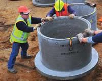
Large scale in situ lysimeter array near Lake Taupo: This is a more direct approach quantifying the impacts of land–use practices and amelioration treatments, such as use of biochar, on reducing the nitrogen entering Lake Taupo. Water in the lake is deteriorating due to nitrogen, of which 30–40% comes from pastoral farmland. Waikato Regional Council has a target of reducing manageable nitrogen entering the lake by 20%, and is exploring nitrogen trading markets as a mechanism to help achieve this. Cut–andcarry lucerne may be an economically viable, low nitrogen–loss option but the effectiveness needs to be quantified.
To provide these data, a specially designed and manufactured lysimeter array has been installed on the western side of Lake Taupo. Each of the 12 lysimeters contains an undisturbed 1–m–diameter soil core 1.5 m high, which weighs about 1.2 tonnes, with the surface of each planted and treated in four different combinations of lucerne, industry standard fertilisers, biochar, and ryegrass/ clover. Leachate is analysed for nitrate, ammonium and phosphate. Rainfall, air temperature, soil temperature and level of leachate in the tanks are being telemetered hourly back to Landcare Research at Hamilton. The research will extend for at least three years.
Channel lysimeters: These are another innovative in situ design with the potential to provide direct feedback to farmers enabling them to modify irrigation schedules, optimising water use and minimising water leaching down into groundwater. Channel lysimeters are inserted horizontally into soil about 1.5 m below the ground surface and just above the water table.
Following a prototype developed and tested at Lincoln, four channel lysimeters have recently been installed, with regional council support, on two dairy farms with stony soils in Central Otago. Irrigation efficiency, both in terms of water and effluent application and impact on leachates, will be monitored from spring (start of the milking season) through summer. The lysimeters and soil moisture sensors are connected to a wireless sensor network supplying real–time data over the Internet, which will enable farmers to tune the efficiency of their irrigation systems. The data will also aid Otago Regional Council in developing policy and resource consenting, and add to research knowledge about the fate of effluent in stony soils.
Māori land visualisation tool: Web–based tools to support Māori resource management
Māori need better and easier access to quality land resource and environmental information when making decisions about their land. With funding from Te Puni Kōkiri (Ministry of Māori Development) we have developed an interactive web–based tool that provides basic land resource information and summary statistics for each registered Māori land block. A pilot version of the tool, shown at a series of conferences and workshops last year, generated huge interest around the country. This year, the tool was released widely for public comment.
It combines updated Māori land block data (property and legal) from the Ministry of Justice with environmental and land resource data from Landcare Research; it is also linked to the National Library’s DigitalNZ records, giving a wealth of additional historical and archival information. Data is displayed over topographic maps, satellite imagery and aerial photographs. It has been designed specifically for Māori land owners and land managers wishing to explore the nature of their land and identify sustainable and potential land use. At this stage it gives a coarse assessment of land type matched to suitability for horticulture, cropping, pastoral farming, forestry, and areas needing long–term protection.
The Māori land visualisation tool should be of enormous benefit to Māori land owners and Māori organisations such as trusts and incorporations, and many government departments.
Resource management framework for Māori:
We have developed a pilot web–based resource management framework (RMF) that provides Māori resource managers with better access to information about statutory obligations and responsibilities in relation to stormwater in estuaries. This work has been carried out in collaboration with Te Ao Mārama Inc. (Southland) and Mana Ahuriri Inc. (Hawke’s Bay) and addresses concerns expressed by Māori resource managers about the difficulties in navigating the complex legislative landscape of natural resource management.
The RMF tool enables users to understand the implications of relevant legislation (e.g. the Resource Management Act and regional policy statements) on their local areas and to find information that will help in responding to requests for resource use. Other key attributes of the RMF tool include the potential to adapt the framework for use on other environmental issues (e.g. water extraction or pest control) and the transferability of the tool to other regions beyond Southland and Hawke’s Bay.
Importantly, the site captures mātauranga from local Māori RMA practitioners (in particular Morry Black of Ngāti Kahungunu, Ngā Raurū and Ngāti Porou) and allows for this knowledge and wealth of experience to be accessed by a wider group of end–users than previously possible. This will have lasting benefit to Māori.