Interactive tools for regional council managers: simulating kill-trap networks in the Cape to City predator control programme

Permanent networks of kill traps have the potential to provide long-term, cost-effective control of vertebrate pests over large areas. Such networks are often initially established with large numbers of traps in order to quickly and substantially reduce the pest population to low levels. It is likely, however, that after the population has been reduced, the number of traps in the landscape is higher than that required for the long-term maintenance of a low-density pest population. Removal of a proportion of the traps at that time will reduce the cost of checking and maintaining the network without reducing its effectiveness.
The optimal number of traps in the landscape depends on a number of factors in addition to the population size of the targeted species. For example, the size of the home range of the species has a significant bearing on the density and/or spacing of the traps required. Rats, for example, have home ranges of about 3 ha, whereas mustelids have home ranges over 300 ha. Thus, if a trap network is set at a spacing of 400 m × 400 m, populations of rats could easily live between trap lines and never be exposed to capture, whereas ferrets and stoats would be likely to encounter multiple traps.
Another factor that can affect the number of traps required for an effective network is the time interval between checking the traps and resetting them. Checking traps too often when populations are low is a waste of resources, as there are likely to be very few traps to clear of carcases and reset. In contrast, checking traps too infrequently can result in many traps having been long triggered by pests and no longer able to catch surviving animals until they are reset. So how can managers decide on a trapping network that will meet their aims?
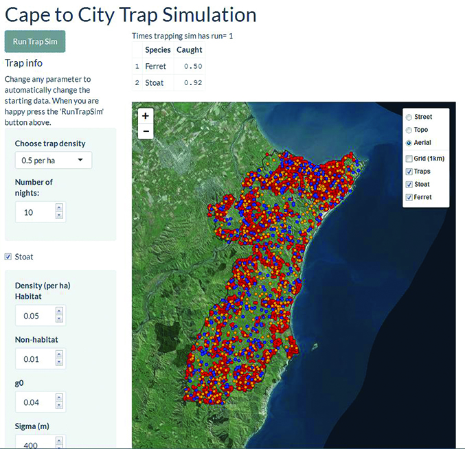
Cape to City is a predator control and ecological restoration programme covering 26 000 ha in the Hawke’s Bay region, encompassing the Cape Sanctuary wildlife restoration project on the Cape Kidnappers peninsula. Andrew Gormley and Bruce Warburton have been working with staff from the Hawke’s Bay Regional Council to develop an interactive tool (a developmental version is available at https://landcare.shinyapps.io/trapsC2C/) that allows managers to examine the effectiveness of various trap spacings on the capture of ferrets, stoats and cats within the Cape to City area (see Figure).
The current version of the tool allows managers to alter the density of traps, the trapping interval and the density of the target species, as well as the density of potential non-target species such as rats, possums and hedgehogs. The tool randomly locates populations of target and non-target species at densities specified by the user across the real landscape (using the LCDB 4.1 habitat map), and then simulates trapping in order to obtain estimates of the percent kill for each species. In its current state the tool can be used to model the initial knock-down of each species and/or for modelling maintenance control over relatively short time periods (i.e. up to a month).
The next stage in the development of this tool is to expand its capability to simulate long-term maintenance control (i.e. several months). This requires incorporating data on population dynamics (births and deaths) into the simulation, along with the migration of each species into the Cape to City area.
The trapping simulation tool will enable managers to make more informed decisions about the effectiveness of various trapping networks, and, when integrated with remote wireless monitoring of traps (another Cape to City project), should significantly reduce the cost of controlling predators over large areas. The interactive tool has been developed in close collaboration with council staff to ensure it generates outputs relevant to their management needs and is accessible through an easy-to-use web-based interface.
This work was funded by the Hawke’s Bay Regional Council and Landcare Research.
Andrew Gormley, Bruce Warburton