A national update on land cover change
The third version of the Land Cover Database (LCDB) – the authoritative record of changes in land cover in New Zealand was publically released at the end of June on our download site. The database classifies all land cover under 33 different classes at three nominal summer periods (1996/97, 2001/02 and 2007/08).
Producing LCDB v3.0 was the major achievement from the first year of our 4-year contract with the Science and Innovation Group within the Ministry of Business, Innovation and Employment (MBIE) to generate new editions and to conduct the necessary research and development to improve mapping quality, efficiency, and accessibility. Building on the first two LCDB versions, produced in 2000 and 2004, the latest database makes use of improvements in the resolution of satellite imagery, as well as Landcare Research’s advances in image processing technology to provide an accurate record of New Zealand’s land cover.
Version 3.0 contains a third time-step based on about 160 satellite images captured over the 2007/8 summer. In addition to the extra time-step, significant improvements have been made to its classification accuracy, its line work quality, and its consistency with other New Zealand map datasets.
Around 64 000 polygons were manually modified in this revision, with about 36% of these being real change between 2001/02 and 2007/08 and the remainder being corrections on previous mapping (at 1996/97 & 2001/02). A further 200 000+ polygons or polygon parts, out of a total of 450 000, were modified by semi-automated adjustments (excluding smoothing artefacts).
We’ve had great support from users of the database. Regional councils, territorial authorities, Department of Conservation, Ministry for Primary Industries, and the Fire Service were given the opportunity to review the draft LCDB v3.0 mapping of their interest area and to provide feedback on general problems as well as specific errors they had identified. At least 16 organisations provided feedback on their areas; in some cases this feedback was comprehensive. Around 3000 of the 64 000 manually modified polygons were the result of checking or other information provided by these collaborating agencies.
Before updating the maps, an automated process was applied to smooth step artefacts found in the previous version. These artefacts originated from pixel level classification and their removal results in a much cleaner and more appealing map product as shown in Figure 1.
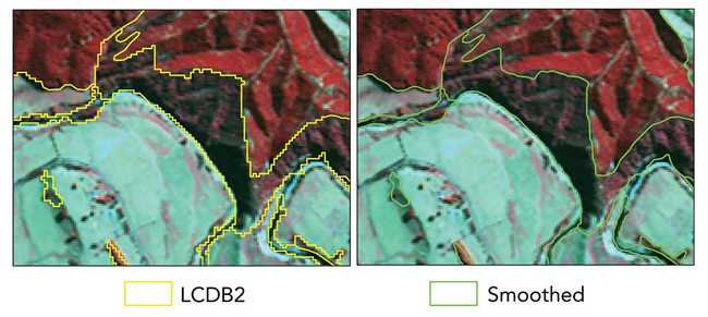 |
| Figure 1. Original stepped boundaries in red, smoothed boundaries in yellow. |
The LCDB technical advisory group decided to adopt the Topo50 coastline to make LCDB easier to integrate with other New Zealand datasets. The process is illustrated in Figure 2, where most classes are clipped or extended to the Topo50 coastline. Three classes – “Mangroves”, “Herbaceous Saline Vegetation”, and “Estuarine Open Water” – are allowed to exist outside the coastline, so an “onshore” flag is used to indicate polygons inside the Topo50 coastline.
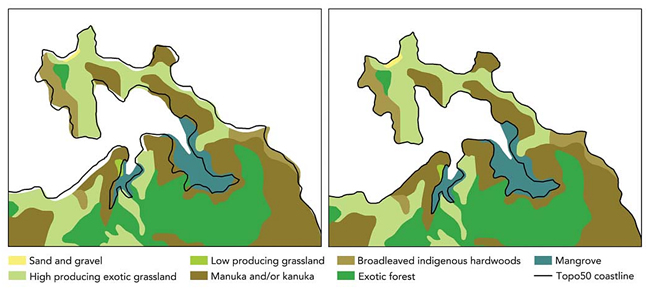 |
| Figure 2. The original LCDB “coastline” was simply interpreted from imagery. As seen on the left, it often deviated from the Topo50 coastline (bold line). On the right, polygons have been made consistent with the Topo50 coastline. |
Currently, we are assessing the accuracy of the new LCDB product and should have initial results by September. We will then go back to users for their feedback on the strengths and weaknesses of LCDB v3.0 and also to survey other datasets held that might be useful to improve future LCDB versions.
Behind all this we have an exciting research programme aimed at improving the efficiency and accuracy of mapping from remotely sensed imagery. A priority here is to integrate automated segmentation methods to reduce the amount of hand-digitisation required. We are also developing smart vector editing techniques to integrate new polygons with existing maps without generating slivers, gaps or breaking topology.
See the LCDB website for more information on the programme.
David Pairman