Water quality issues at the regional scale
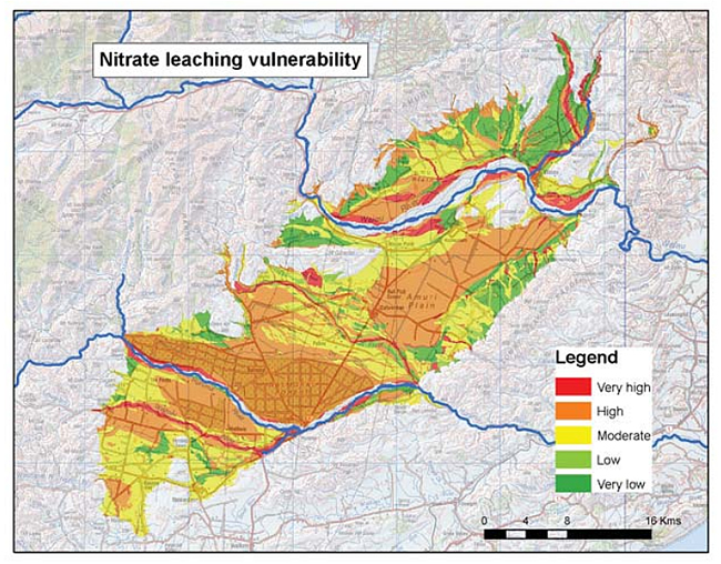
Figure 1. Nitrate leaching vulnerability for part of the Canterbury region.
Regional Councils are charged with managing the cumulative effects of land use on water quality. With the promulgation of the National Policy Statement for Fresh Water and the recent release of the second Land and Water Forum Report, more effective mechanisms for managing land use to meet water quality limits are urgently required.
Landcare Research, through its collaborative relationship with Environment Canterbury, has helped develop this evidence base for the Canterbury region by comparing, integrating, and synthesising data and modelling across different soils, land uses, and scales (field, farm, aquifer, catchment, and regional).
Developing the science
In a simulation study we showed that current methods and technologies for measuring leachate under grazed pasture are woefully inadequate. Impractical numbers of measuring devices are required to estimate accurately average leaching from a grazed field. This is of critical importance, given that this type of data is used by agricultural researchers to develop and evaluate farm-scale leaching models, and some regional councils are hoping to ensure compliance with nutrient discharge limits through such measurements.
In another study, commissioned by Environment Canterbury, the science sector was requested to run farm-scale models to provide estimates of nitrate leached below the root zone under a range of land uses for a range of Canterbury soils. We selected and characterised the soils, then compared and critiqued the modelled values, producing a consensus report of best available estimates of leaching values.
At the aquifer/catchment scale, and in collaboration with Lincoln Ventures Limited, we have developed a spatial model (AquiferSim) to understand potential land intensification options on water quality in aquifers and spring-fed streams. This model is specifically designed to explore the impact of different scenarios within minutes – rather than weeks, as with more complex models. Another design criterion was its capacity for use where there is limited geohydrological data (good information is only available for a few aquifers in New Zealand). AquiferSim was tested in the Central Canterbury Plains (with good data) and in the Hurunui where there is little data information. The Hurunui case study involved the development of methods to integrate with an existing catchment-scale model for surface water. This modelling work contributed to the Environment Canterbury’s Land Use and Water Quality Project, a collaborative process with stakeholders that resulted in the Hurunui and Waiau River Regional Plan. We are now working with Environment Southland to apply AquiferSim to the mid Mataura basin.
At the regional scale we have developed new spatial models of contamination risk by bringing together Landcare Research’s powerful new soil database S-map and relevant research on contaminant pathways. This helps landowners determine where mitigation land management practices are needed, and enables regional councils to apply more appropriate consenting rules for effluent disposal and septic tank discharge fields.
Developing and evaluating policy
Working with Environment Canterbury we developed a new method for allocating a catchment-scale nutrient limit between farms. This method focuses the requirement for more intensive mitigation practices on those land areas where there is a nitrate contamination problem, i.e. intensive land use on leaky soils in catchments known to have poor water quality.
We have also worked with Environment Canterbury to produce regional maps of nitrate concentration in the shallow ground water in Canterbury (using farm-scale modelled nitrate values). These maps were used in the Canterbury Water Management Strategy Strategic Framework document to highlight the impact of intensification due to increased irrigation. More recently we have used an updated regional nitrate-leaching map to provide statistics on the impact of nitrate thresholds being considered for the draft Canterbury Land and Water Regional Plan.
Linda Lilburne