SedNetNZ: a new model to predict land management effects on erosion and sediment yield
Land managers are increasingly turning to spatial modelling to predict the effects of land use on environmental outcomes.
Effective land-use modelling requires tools that can target critical source areas for sediment generation and subsequently predict the impacts of future upstream land management scenarios on downstream water quality and quantity. There is also a need to evaluate contemporary loads in relation to the natural or background loads.
Existing erosion and sediment yield models can contain no information on the contribution from different erosion processes (e.g. Suspended Sediment Yield Estimator, NZeem®), do not simulate the full range of erosion processes present (e.g. GLEAMS), or require vast amounts of data and processing power to run them (e.g. SHETRAN). There is clear need for a model that combines realistic data requirements with better erosion process representation, explicit linkages between hillslopes and channels, and simulation of catchment-scale connectivity, so that we will be better able to simulate the effects of changes in land management on upstream sediment loading and downstream responses.
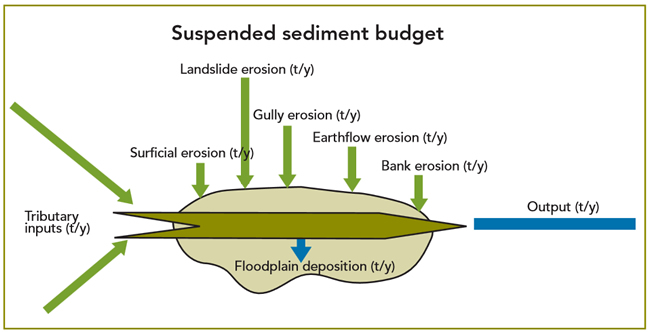
SedNetNZ is based on the Australian SedNet model, a spatially distributed, time-averaged model that routes sediment through the river network using a sediment budgeting approach. It is based on a relatively simple physical representation of hillslope and channel processes that contribute to each stream link in a river network (Figure 1), accounting for losses in water bodies (reservoirs, lakes), and deposition on floodplains and in the channel. SedNetNZ will simulate the contribution of sheet and rill erosion, landslides, earthflows, gullies, and bank erosion, processes that collectively account for the majority of erosion and sediment generation in the New Zealand landscape. It also accounts for floodplain deposition (Figure 2).
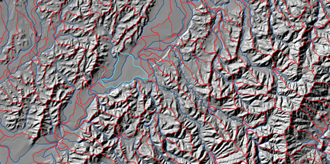
The Manawatu River is being used as a case study for model development because it has major erosion and sedimentation issues, considerable existing erosion and sediment yield data, and a high likelihood of major land management change that can be used to test the model. To parameterise the model considerable effort was needed to characterise erosion processes within the Manawatu catchment, including mapping of historical landslides and determining the relationships between landsliding probability and slope angle, as well as mapping earthflows and determining their contribution to the channel network.
As part of the background work to ensure the model accurately simulates river sediment loads, we have analysed suspended sediment data collected by Horizons Regional Council at eight sites within the Manawatu catchment over the last ten years. Measured suspended sediment yields range from 960 t/km2/yr in the Pohangina River to 440 t/km2/yr in the Tiraumea River, considerably less than yields predicted by existing models.
When fully developed, the SedNetNZ model will be a major step forward in providing land managers with tools to simulate erosion processes realistically and to determine the linkages between hillslope and channel processes.
John Dymond & Les Basher
Figure 1. Stream link and river network in part of the Manawatu catchment.
Figure 2. Conceptual structure of SedNetNZ for each stream link.