Biodiversity
Outcome:Improved measurement, management, and protection of New Zealand’s terrestrial ecosystems and biodiversity, including in the conservation estate.
The integrity of our iconic natural places – and the biodiversity they support – is central to our identity, lifestyle and the economy. Intergenerational responsibility for the management of indigenous ecosystems, expressed through kaitiakitanga, is also central to Māori aspirations.
Since human settlement of New Zealand, many ecosystems have declined extensively in area and function, often as the result of invasive species. Although one-third of New Zealand’s land area is legally protected, there is a strong bias in these areas toward montane and alpine regions. Many of our naturally uncommon ecosystems occur outside protected areas. Lowland and dryland ecosystems face increasing threats from agricultural intensification, conversion to plantation forestry, mining and urban development as well as invasive species.
On the other hand, native vegetation is naturally regenerating across large tracts of retired marginal land. Wildlife sanctuaries, largely driven by community groups, continue to enhance biodiversity across 56 000 ha of mainland New Zealand and near-shore islands. Coordinated community action, based on the best available science, will be critical to progressing the ‘Predator-Free New Zealand by 2050’ initiative locally, regionally and nationally.
The effective management of biodiversity requires accurate knowledge of its composition and of changes in its state through time and in different ecosystems. New Zealand’s international reporting on our biodiversity also requires a systematic approach to monitoring and measurement of our biodiversity. Such an approach allows the most threatened components of biodiversity to be identified through targeted research and addressed through enhanced understanding of risk, how more effective management can be achieved, and opportunities to improve the efficiency and effectiveness of biodiversity management and policy.
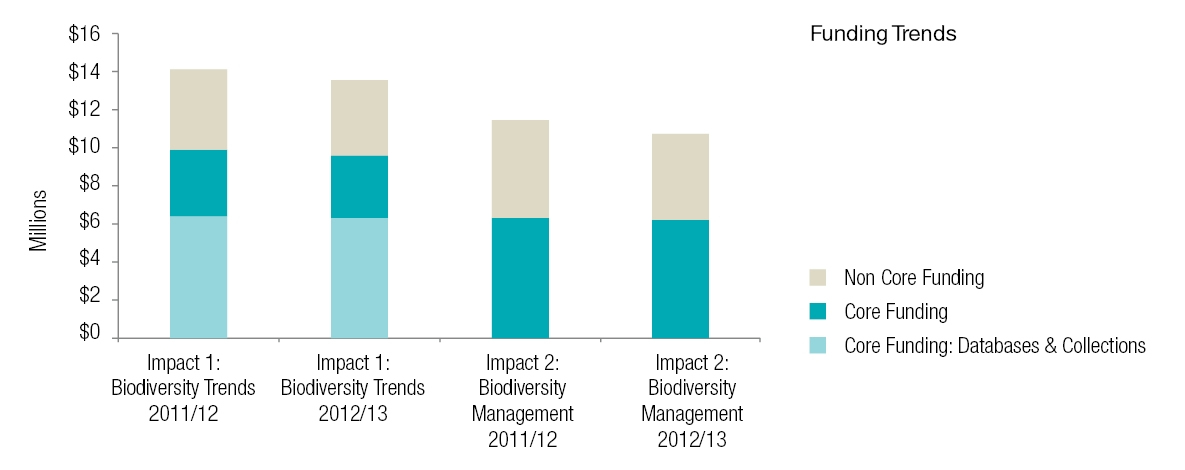
Impact 1: Trends in national and regional biodiversity on public and private land are understood and based on best available definitions and descriptions for species and comprehensive indices of ecological integrity
KPI:
DOC and regional councils are using comparable metrics to measure status and trend and impacts of interventions on biodiversity within their jurisdictions.
2010/11 Baseline situation:
Various methodologies were used to assess biodiversity so it was difficult to understand national and regional trends and to assess the impact of management interventions.
Progress 2011/12:
- As a basis for determining status and trend regional councils and DOC began using our ecological integrity metrics in their reporting, including DOC in its 2011/12 Annual Report.
- Regional councils (through the Biodiversity Forum) and DOC (through its Planning, Monitoring, and Reporting Unit) are adopting the ‘ecological integrity’ concept, and its biodiversity metrics.
Progress 2012/13:
- DOC’s use of robust, nationally-consistent, objective metrics was instrumental in its annual reporting gaining Office of the Auditor- General approval.
- Regional councils have a suite of metrics for monitoring biodiversity on public and private land; metrics are compatible with those used by DOC.
- Status data are provided by our nationally significant collections. The e-Flora was extended with descriptions of one moss family and five fern families; NVS added 100 datasets for 4860 plots; information from all 70 volumes of Fauna of New Zealand is now available via the Biotaxa website.
Impact 2: The most threatened ecosystems, habitats and species can be managed to reduce the risk of decline in native biodiversity.
KPI:
Consents related to land use change under the Resource Management Act (RMA) are informed by a scientifically-based set of criteria that take account of cumulative effects on habitat availability.
2010/11 baseline situation:
Resource Management Act processes were informed by a variety of evidence, with no nationally-consistent biodiversity framework or context.
Progress 2011/12:- Cumulative effects of land-use intensification on highly-threatened dryland ecosystems in inland eastern South Island were used by the Environment Court and High Court in four hearings considering resource consents for major land-use changes.
- Landowners, business and public groups reached agreement that100,000 ha of the Upper Waitaki Basin required protection.
- Of New Zealand’s 72 naturally uncommon ecosystems, the IUCN’s ecosystem Red-List criteria identified 18 as critically endangered, 17 as endangered and 10 as vulnerable.
Progress 2012/13:
- District plans, which guide resource consents, increased protection for indigenous vegetation for lower elevations in highly-threatened dryland ecosystems.
- Court decisions informed by our science protected naturally uncommon ecosystems in the upper Hurunui / Lake Sumner margins and a significant area of North Island frost flat.
- We participated in an international working group assessing application of IUCN ecosystem-Red List criteria and protocols to the Oceania Region, to aid biodiversity monitoring and conservation action (page 13).
KPI:
Management decisions by DOC, MPI and regional councils, aimed at reducing threats to species and habitats, are based on robust risk models that reflect best available knowledge about the efficacy, cost and acceptability of management strategies and tools.
2010/11 baseline situation:
Management decisions largely ad hoc with inconsistent application of robust biodiversity value and risk modelling.
Progress 2011/12:
- Our framework, which links species extinction rates to changes in both spatial distribution and population size, helps sanctuaries and DOC to compare likely outcomes from different management actions.
- Updated threat listings for native biota enable DOC to reallocate resources for managing the most critically threatened species.
- DOC and 14 councils used our risk model to rank their top weeds.
Progress 2012/13:
- Decision frameworks are in use to support threatened species recovery, ecosystems protection, and regional council pest control.
- DOC is using our masting model to predict and cost-effectively manage vertebrate pest irruptions.
- DOC and the NZ Army have evidence from us that biocontrol of heather benefits indigenous biodiversity compared with herbicide control.