How to tell our wetlands from our drylands
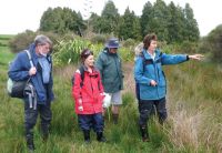
Wetland delineation workshop led by Bev Clarkson (blue parka) (David Palmer).
The RMA definition of a wetland is broad and often difficult to apply. Confusion over where a wetland starts and finishes has created difficulties, especially for regulatory authorities, land owners, DOC and the Environment Court.
To provide greater clarity and consistency, we developed a delineation system for New Zealand, based on a similar system used in the USA for regulatory purposes. The system is vegetation-based because, although water levels fluctuate, plants respond to longer term changes.
Nearly 1000 native and exotic plant species were classified according to their prevalence and dominance in five wetland habitat classes. Where plant-only assessments are likely to be inconclusive (e.g., sparsely-vegetated sites, such as mudflats or following major disturbance, and some gumlands and ephemeral wetlands), additional assessments of soils and hydrology are recommended.
Training workshops and advice have been provided to nine councils, DOC, Meridian Energy, researchers and consultants. The system has been used by DOC and Environment Canterbury in hearing processes, and by Northland Regional Council to delineate wetlands for protection in gumlands development consents.