National Outcome 2: Sustainable Land Use
Achieve the sustainable use of land resources and their ecosystem services across catchments and sectors
Background
New Zealand’s land resources sustain primary sector production, ecosystem services (e.g. clean water, fertile soils), habitat for valued biodiversity, and the aesthetic and intrinsic values on which New Zealand’s economy, tourism, and identity are based.
The demand for environmental information to support effective management of land resources in New Zealand is both urgent and growing. Some of our most important natural resources have been over-allocated or have reached critical environmental thresholds as a result of unsustainable land-use practices.
In response, the Natural Resources Sector has prioritised improving national environmental information and initiated a major programme to fill knowledge gaps to enable policy, regulatory and operational agencies, and land owners to manage land within environmental limits.
Impact 2.1: The status and trends of land resources and ecosystem services (including their interactions) are known and understood
Core Funding Investment
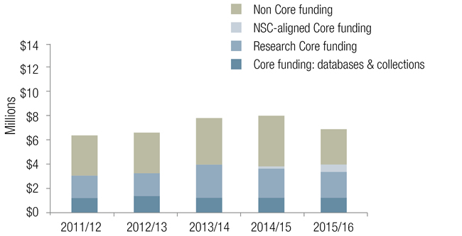
Key Performance Indicator 2.1: Key elements of the Land Resource Information System have been enriched and are being used under the New Zealand Government Open Access Licensing (NZGOAL) framework for web services
Core-funded progress for 2015/16 is reported in the achievements table, particularly under:
Highlights
Global leadership of Pacific Soils Partnership: Landcare Research co-led the second Pacific Soils Partnership meeting with government representatives from five Pacific Islands and CSIRO Australia to identify mechanisms to address priority soil issues in the Pacific (nutrient management, soil information security and capacity building). This work forms part of the United Nations FAO Global Soil Partnership, and is also part of our international leadership in soils research. The meeting resulted in a communique that was tabled to the UN FAO Plenary in May, with the work of Landcare Research and our partner agencies also supporting the development of a business case for $2m investment via ACIAR (Australian Centre for International Agricultural Research) and IFAD (UN International Fund for Agricultural Development). If successful, the regionally focused project will include the development of a Pacific Soils Portal to be hosted by Landcare Research. This is an excellent example of ‘science in diplomacy’ in action, whereby science helps grow NZ’s positive reputation and contribution offshore.
Land-use information to support the Water Reforms: New Zealand does not yet have accurate, up-to-date land use data. Under contract to MfE, we reviewed land-use mapping methodologies, piloted an assessment of land use efficiency, and trialled large-scape remote sensing of agricultural land use to help shape the design of a national land-use map/model to better monitor and report the impacts of land-use intensification on environmental quality (particularly for fresh water). This work demonstrates the wide suite of research expertise we can apply to support New Zealand’s water reforms.
Supporting Māori economic development: We have been working with a number of Iwi, undertaking land and soil profiles for their rohe. We are working with local economic development strategies ‘to’ support initiatives which provide more sustainable options for land use, which have led to discussions with local Councils on how our work could support such strategies.
Charting future national soil management requirements: Our National Land Resource Centre has led a suite of translational research across the science system to identify current pressures on New Zealand soils, soil management practices and readiness to adapt. The resulting three reports – the last of which focused on future requirements for soil management in New Zealand – made a number of recommendations to senior leaders in government and primary industry. These will form the basis of a national Soils Action Plan to be led by MPI.
Benefits of sediment control: After a severe storm in the Manawatū–Wanganui in 2004 caused 62 000 landslides, Horizons Regional Council implemented the Sustainable Land Use Initiative (SLUI), a major soil conservation programme. Our SedNetNZ model was used to evaluate the impact of the SLUI programme in the Manawatū catchment, and results suggest that by 2040, sediment loads will decrease by about 40%, representing an investment with an annual rate of return of 30%. Ongoing application of SedNetNZ with Waikato and Hawke’s Bay Regional Councils is assisting them identify and prioritise sub-catchments requiring soil conservation interventions to meet water quality targets.
Impact 2.2: Opportunities and threats to land resources and ecosystem services are recognised and balanced to maintain or enhance the provision of ecosystem services
Core Funding Investment
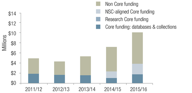
Key Performance Indicator 2.2: Regional councils and the irrigation, pastoral, and arable sectors are using knowledge of soil variability to improve the match between land-use practices and land capability
Core-funded progress for 2015/16 is reported in the achievements table, particularly under:
Highlights
Launch of interoperable S-map data to OVERSEER®: In mid-May, OVERSEER® version 6.2.2 was released. This version automatically extracts data on soil properties that control nutrient leaching directly from Landcare Research’s S-map (national soils) database. This result is the culmination of over 3 years work developing and applying new technologies and approaches in big data and data standards. The new interoperability between OVERSEER® and S-map reduces the manual input of 18 soil data fields by OVERSEER® users, and removes the risk of manual error (or manipulation) by users that results in higher than appropriate nutrient budgets for the property. This is fi rst time OVERSEER® has connected externally to provide auto-population of data, and provides important assurance to support OVERSEER® being used as regulatory tool. The release was widely reported and welcomed in mainstream and social media, highlighting Landcare Research’s national leadership in soils and informatics.
Extending the value of the Land Use Capability Classification System (LUCCS): The LUCCS is a key national land information layer used to assess what land can be used for (i.e. its carrying capacity). Improving the utility and relevance of the LUCCS is critical to supporting the water reforms that set nutrient limits, and developing land for productive use. We recently published a National Land Use Capability Extended Legend that correlated, amalgamated, and rationalised LUC units from various regional legends into a single New Zealand-wide set of LUC units, for ready use across the country. Major stakeholders have responded to the new Legend very positively, and support further developments to make available online an interactive Legend with full spatial search capability. Better nutrient management in the Manawatū: We are partnering with Massey University to deliver a programme of work on land-use mapping, nutrient budgeting, and nutrient attenuation to improve nutrient management in the region. This helps build a strategic relationship with Horizons Council, in support of the Crown’s regional growth strategies.
DairyNZ Riparian Planner tool: DairyNZ’s Riparian Planner tool went live in March. It was developed by Landcare Research through a commercial contract with DairyNZ and has generated high interest in the primary and government sectors. The tool was profiled in DairyNZ’s April ‘Inside Dairy’ publication and through a seminar to about 40 senior government and primary sector stakeholders. The Riparian Planner tool will help dairy farmers, industry and farm consultants meet Sustainable Dairying Water Accord targets (all dairy farms must have a planting plan in place by 2020, with all Accord waterways planted by 2030). It provides practical support to help landowners meet compliance, and enables sector bodies, councils, and central government to quantitatively assess progress towards targets.
Supporting water reforms: We have been active in leveraging our land resource expertise to support community and council decision-making on limits for water quality and quantity. As part of this work, we met with a range of groups, including:
- Ruamāhanga Whaitua Committee, to present a general overview of indicators/attributes used to evaluate socioeconomic impacts as a result of changes in freshwater management. The Whaitua Committee will agree on attributes to be evaluated and incorporated into a catchment economic model being developed to inform the collaborative process.
- Whangarei Harbour Catchment Group, to present a general overview of the Whangarei Harbour Catchment Modelling Project (a Joint Venture between MPI and Northland Council), and discuss early results on the cost of mitigation to reduce sediment and E.coli in the catchment. The Catchment Group will use our work to help inform limit-setting processes.
- Takaka Freshwater and Land Advisory Group (FLAG), Tasman District, to discuss the strengths and limitations of our WaterWheel and water balance modelling projects being used to help the FLAG draw conclusions about appropriate water allocation, environmental flow, security of supply, and water quality limits in the District Plan.