The National Possum Model – involving more than 30 million individuals
The National Pest Management Strategy for bovine TB in New Zealand proposes three options for managing wildlife vectors: containment of the pests, rollback of the disease, and disease eradication. Under all three scenarios, accurate, real-time and future predictions of possum abundance will be critical in order to make management decisions. Also possums have significant environmental impacts as they defoliate trees and prey on the eggs and chicks of native birds. Conservation efforts could be coordinated better if the Department of Conservation, regional councils and private groups have a more complete, up-to-date picture of when and where possums are being controlled. James Shepherd and his colleagues have developed a prototype individual-based model predicting the abundance of possums nationally: the National Possum Model. The model uses open-source GIS software and integrates existing land cover maps, jurisdictional boundaries, and control area boundaries. The model will be delivered and updated over the Web. However, users will need to input data on possum control in order to receive useful current and future population predictions.
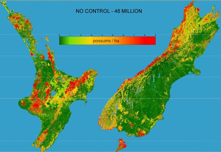
Based on estimates of possum density and home-range size, the model describes the behaviour of individual possums located explicitly in a map of their habitat; hence it is referred to as an ‘individual-based model’. Each individual has an Easting and Northing coordinate representing the notional centre of its home range. Each home range is assumed to be fixed, unless the possum ‘decides’ to disperse. Key events in an individual’s lifetime comprise birth, death, and dispersal, and these are simulated as stochastic (random), competing Poisson processes, i.e. there is uncertainty in the timing of each event. It is assumed that births and deaths are affected by the local density of possums. In the model, the population density of possums is represented by a map that is the sum of the intensity of home-range use by all individuals. Possum carrying capacity (i.e. maximum density) varies across the landscape and is predicted from detailed habitat maps derived from satellite imagery (Fig. 1). Births in the model occur as a single ‘pulse’ each year.
Due to the random nature of events in a possum’s life, a single run of the model provides only one of many possible ‘realisations’ of changes in the possum population. Predictions require many individual model runs with different random starting values to build up a distribution of results from which the mean and spread of behaviour is drawn. This type of modelling is often termed Monte Carlo simulationand is computationally intensive. Typically, a prediction for the outcome of a possum control programme, for example, is created from 500 model ‘runs’. While this amount of processing does seem prohibitive, each run is independent and can therefore be carried out simultaneously on a cluster of computers set up to work as a single coherent unit. Eventually James and his team intend to move their modelling to a nationally based, high performance computing network. The equivalent of a true super computer will enable the complete suite of Monte Carlo simulations to be undertaken in the same time it takes for one run of the model on a desktop computer.
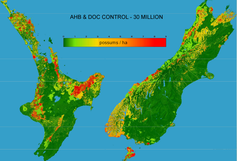
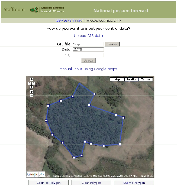
The National Possum Model will provide detailed and realistic forecasts of possum abundance, now (Fig. 2) and at regular time intervals into the future. In other words, it will be a dynamic, continuously updated, national map of possums. To achieve this will require user input of the extent and effectiveness of recent control programmes to ‘reset’ possum numbers locally and to update the national prediction (Fig. 3). An important part of the process will be managers providing feedback to modellers when predictions differ from reality, so access to pre-control monitoring data will be invaluable. It is expected that the effectiveness of the model will be improved by many areas of Landcare Research’s current research: satellite image processing and subsequent classification of land vegetation cover, understanding the relationship between vegetation cover and possum density, and improving model parameters for home range distribution and dispersal of possums through analysis of possum movement behaviour using GPS collars.
This work is funded by the Foundation for Research, Science and Technology (Programme C09X0909: Invasive Mammal Impacts on Biodiversity).
James Shepherd, Mandy Barron & Roger Pech
Fig. 1. Modelled equilibrium density of possums without control.
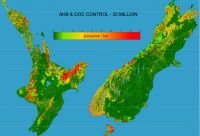
Fig. 2. Modelled density of possums following control programmes by the Animal Health Board and the Department of Conservation in 2008 and 2009.
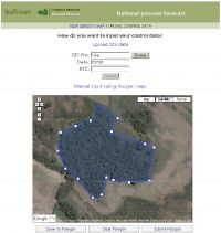
Fig. 3. Example of a web page for submitting the results of a recent possum control programme.