Issue 5, October 2014
In this issue:
|
|
Editorial
 Big, small, natural and a Challenge!
‘Big, small and natural’ is where everything is heading, according to an Intel futurist who spoke to a group of New Zealand business leaders recently.
He was talking about the power of ‘big’ computing capability, the ability to focus on things at a ‘small’ scale and of course the growing importance of small handheld devices, and our ability to sense the ‘natural’ world in new ways.
The themes of ‘big, small and natural’ are certainly evident in three highly innovative MBIE research contracts we have recently won (summarised below). We are also pleased to be included in three additional new projects led by other organisations.
An example of ‘big’ is the first of those MBIE contracts to lead the development of a range of valuable information products to inform land management decision making and environmental reporting. A diverse team of researchers will integrate a wide range of substantial land resource and biodiversity datasets. Through innovative data analysis and modelling, they will provide credible information products, packaged for convenient use by decision makers.
Another example of ‘big’ is the comprehensive new Environmental Impact Assessment that we will lead for the Ross Sea region in Antarctica. By integrating environmental, biological and human activity datasets we will achieve a step-change in understanding of the state of the region’s environment and how we manage human activities there.
At the other end of the scale, our clever DNA analysis work effectively illustrates the power of the ‘small’ and our growing ability to sense the ‘natural’ world. MBIE has renewed our funding to develop a credible DNA-based biodiversity assessment service for land managers. From a soil sample we have demonstrated the ability to provide information about the presence of everything from tiny bacteria to large mammals.
All of these MBIE research contracts will be undertaken in collaboration with other science providers and important stakeholders. The breadth, scale and nature of our work means we have to be integrative, which has become a real strength at Landcare Research.
The other big news was the launch of the new Biological Heritage National Science Challenge by Science and Innovation Minister Steven Joyce. Landcare Research is the contracting agency accountable for the success of the Challenge. Government will invest around $26m of Challenge funding over the first five years, during which period Landcare Research will align around $32m of its Core contract science to the Challenge.
Together with the 21 other partners we will set about undertaking research that will reverse the decline in our all-important bio-heritage – from cows to clover and kaka to kauri. We will be creating a world-class science platform by bringing together biodiversity and biosecurity research for the first time, integrating research on native and exotic species, and spanning both natural and productive landscapes. It is a very exciting initiative and I know I speak for all the research partners when I say we are certainly ‘up for the challenge’.
As always, I welcome any feedback about our research covered in this edition.
Dr Richard Gordon, Chief Executive
Weed and pest management
 Diminishing Impact of RHD
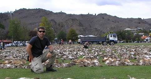 The rabbit haemorrhagic disease virus (RHDV) is still killing rabbits in New Zealand 16 years after its introduction but its impact as a biocontrol agent appears to be waning, according to a study by Landcare Research scientist, Carlos Rouco Zufiaurre.
Carlos analysed kill rates at Alexandra’s Great Easter Bunny Hunt over the past 23 years to arrive at the conclusion.
Contact: Carlos Rouco Zufiaurre
Media Coverage: Calicivirus and the Great Easter Bunny Hunt
Kiwi Science at Work on Aussie Pest Problems
New Zealand science that assists Australian farmers predict mouse outbreaks could soon be applied on this side of the Tasman.
MouseAlert is a new interactive website based on Google-type mapping technology allowing arable crop growers in Australia to record and view mouse activity in their local area in real time. It helps inform the community about changes in mouse numbers or damage, and when to implement control, sooner rather than later, before an outbreak causes severe damage to crops.
Landcare Research is providing expertise on building information from farmers into computer models that forecast outbreaks of mice, as part of a partnership with the Invasive Animals Cooperative Research Centre (IA-CRC) in Australia.
Researcher Roger Pech says the same technology could soon be applied to pest species in New Zealand including wasps, predators, pest birds, and possums as part of work undertaken in the National Science Challenges.
MouseAlert can be used with cell phones and other mobile devices in the field, and a community facility will enable farmers to create online groups and share observations of mouse activity among members. The next stage will be development of a notification system so members of a group can be alerted to changes in mouse activity in their local area as soon as it happens, enabling a coordinated local response.
Contact: Roger Pech
Website: MouseAlert
Media Release: Kiwi science at work on Aussie pest problems
Identifying Cotoneaster
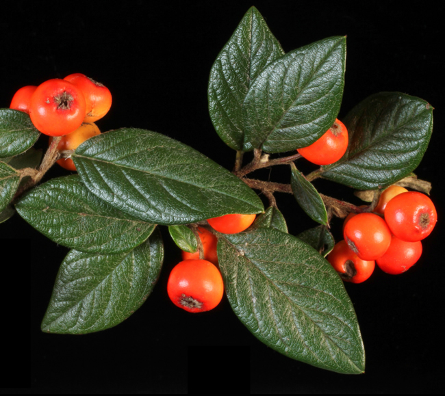 A new interactive key has been developed to help biosecurity professionals identify varieties of Cotoneaster.
The ornamental shrub is a good example of an introduced genus that regional council staff, horticulturists and other plant decision makers need to keep an eye on. Most of the 26 species that are known to be in New Zealand have originated from the Chinese Himalaya. Some species have been cultivated in nurseries and are common in gardens. Others have spread in the wild and have become troublesome weeds. One, Cotoneaster simonsii, is banned from sale.
Cotoneasters are frost-hardy, some will grow under native forest, and their seed is effectively spread by birds. Some species have become invasive weeds in forest and scrub, and they are common on roadsides, where they often spread on to adjacent productive farmland.
The shrubs are notoriously difficult to remove from gardens. When properties in small rural communities are abandoned and the gardens are no longer managed, the plants can quickly spread to adjoining land. Cotoneasters also attract the attention of orchardists as they are a host for fire blight, a disease of pip fruit trees.
Contact: David Glenny
Website: Key to Cotoneaster species present in New Zealand
Woolly Nightshade Lace Bug – A Shady Operator
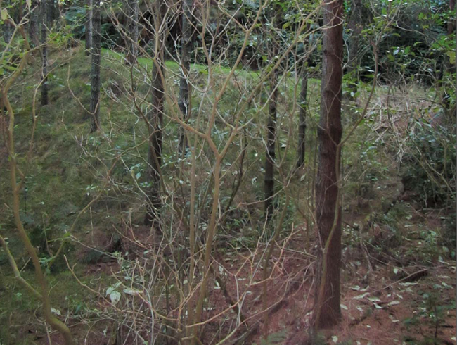 New evidence is suggesting the woolly nightshade lace bug (Gargaphia decoris), first released in New Zealand in 2010 to counter the problematic weed, is having a considerable impact out of direct sunlight.
The lace bug, which was widely released but has suffered from predation, appears to be successfully defoliating woolly nightshade plants that are in shade in Bay of Plenty.
This story, and other biocontrol news, is covered in the latest edition of What’s New in Biological Control of Weeds?
Contact: Simon Fowler
Newsletter Article: Lace Bug Does Best in Shade
Potential Tutsan Biocontrol Agents in Containment
Landcare Research is investigating two small European insects as potential bio-control agents against the pest plant Tutsan (Hypericum androsaemum).
Tutsan is a significant pest in parts of the Central North Island because it forms extensive patches that take over agricultural, production and conservation land. Unpalatable to stock, hard to kill, and shade tolerant, Tutsan is particularly prevalent in areas where the land has been disturbed by the likes of forestry – much like gorse and broom does.
Hugh Gourlay recently travelled to Georgia in Europe to collect specimens of a leaf-feeding beetle (Chrysolina abchasica) and a fruit, leaf and stemfeeding moth (Lathronympha strigana) that are known to attack Tutsan. They are now in containment at our Lincoln site.
“The beetle attacks and feeds on the foliage while the moth attacks stem material,”
Hugh says. “They seem to be host-specific in their native range and quite damaging to Tutsan so it will be good to get them settled into containment to undertake more testing and research. This is likely to take up to one year.”
We have permission from the EPA to import the beetles and moths and will undertake the testing on behalf of the Tutsan Action Group, a farmer-led action group with support from Horizons Regional Council and the Sustainable Farming Fund.
Meanwhile, we’re also investigating plant pathogens as potential biocontrol agents for Tutsan.
Contact: Hugh Gourlay
Video: Potential Tutsan biocontrol agents
Media release: Potential biocontrol agents settling into containment
Land & Water
Structured Decision Making for Collaborative Planning – new Policy Note
With collaborative approaches being promoted for freshwater decision making, Landcare Research’s latest Policy Brief explains how Structured Decision Making (SDM) can provide a clear framework for identifying values and assessing the consequences of different policy options.
Contact: Suzie Greenhalgh
Factsheet: Structured Decision Making for Collaborative Planning
New Insights for Decision Making and Reporting
Landcare Research is about to lead the development of a range of information products that will provide new insights for land management decision making and environmental reporting.
A diverse team of researchers will integrate a wide range of existing land resource and biodiversity datasets. Through innovative data analysis and modelling they will provide credible information products, packaged for convenient use by decision makers.
Science leader, Anne-Gaelle Ausseil says the information will support central and regional government, iwi and industry to report on the state of the environment in a standardised, statistically robust and transparent way.
“We will use the framework of ‘pressure, state and impact’ indicators to assist the Ministry for Environment, Statistics NZ, Department of Conservation and regional councils in environmental reporting and land/water decision-making.
“Through advanced data analysis and work with custodians of the information and end-users, we will develop indicators for soil health, land use, and species occupancy.”
The research team will develop techniques to characterise the provenance, quality and uncertainties of the data, and workflows of the information to enable an auditable process. The information products will be available through existing portals, such as LRIS, Landcare Research's national land resource information portal, and via open standards-based web data services.
“The team is building on a proven track record of working with key stakeholders to convert data/knowledge into policy-ready information. We will be accessing all relevant data, analysing it for environmental reporting and decision making, and delivering it in accordance with national and global standards.
“Having a coherent data ‘landscape’ enables New Zealand to better respond to emerging risks and opportunities, and reinforces our global leadership in environmental stewardship.”
Contact: Anne-Gaelle Ausseil
Land Cover Database Expanded
 The fourth version of the Land Cover Database (LCDB) – the authoritative record of the state and changes in land cover in New Zealand – has been produced by Landcare Research.
LCDB is a digital map of the surface of New Zealand created using satellite imagery which contains detailed information on categories of land cover and boundaries, and is a record of land cover changes over time.
Three previous editions (LCDB1, LCDB2 and LCDB v3.3) show the state of New Zealand’s land cover in 1996, with new data for 2001 and 2008 progressively added into each later edition. These editions have made the LCDB critical for central, regional and local government, industry and research institutions. The information is used for a wide range of land, water and biodiversity management, pest control and monitoring, risk analyses, and environmental monitoring and reporting. For example Land Information New Zealand (LINZ) uses it for vegetation features on their Topomaps such as mangroves or native and exotic forest while the Fire Service uses it for fire risk modelling.
Researcher David Pairman says the goal is that by 2015 end-users will have access to a well-established series of LCDB editions that provide the authoritative record of land cover and land cover change in New Zealand. These datasets will be widely used to support decisions on land utilisation, along with monitoring and reporting requirements.
Users can download the database from Landcare Research’s data portal and use a GIS (Geographical Information System) to manipulate the data and produce the information they require.
Contact: David Pairman
Website: LRIS Portal
S-Map Online Continues to Expand Coverage
 Farmers and land managers across the lower South island and parts of the North Island now have easier access to detailed soil data thanks to a significant upgrade of S-map Online.
S-map Online is a web browser service which provides easy access to information on the soils likely to be found at a location of interest. It’s based on “Google Earth” style navigation to make it easy to search, view and query as well as explore interactive maps of soil properties such as soil drainage and available water. Users can also learn about soil variability, view detailed information about soil classes or attributes, create custom PDF soil maps for printing, and for specific locations, download soil factsheets which provide more detailed knowledge of soil properties and information relevant to a variety of potential uses.
The latest S-map online update includes the addition of 1.5 million hectares of farmland across Southland and Otago as well as more coverage in the Hamner Basin, Greymouth to Hokitika and the area between Cheviot and Kaikoura. In the North Island coverage now includes Manawatu and around Otaki.
Researcher Sam Carrick says that another key update means soils information can also be directly inputted into a range of land simulation models including Overseer, the agricultural management tool which assists farmers and their advisers to examine nutrient use and movements within a farm to optimise production and environmental outcomes.
Work continues to expand S-map Online across more parts of New Zealand.
Contact: Sam Carrick
Website: S-map Online
Minimising the Environmental Impacts of Mining
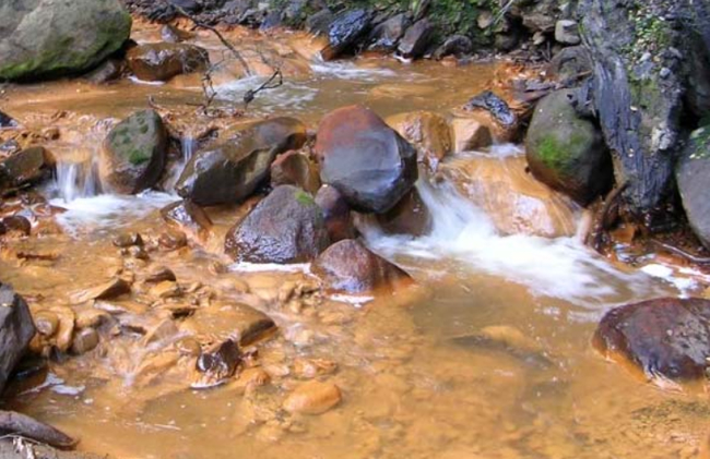 New fact sheets for avoiding mining impacts on streams and for rehabilitating land after mining are now available on the Landcare Research website.
These resources have been developed as part of a collaborative programme that won the 2014 Minerals West Coast Environmental Award.
The group, led by CRL Energy Ltd, recently received MBIE funding to develop a New Zealand Mine Environment Life Cycle Guide to assist regulators, mining companies and other stakeholders to negotiate mine closure successfully, avoiding legacy issues for future generations.
Factsheets: Minimising environmental impacts of mining
Sustainable Development
'Ecosystems Services' Review of the Kiwifruit Industry
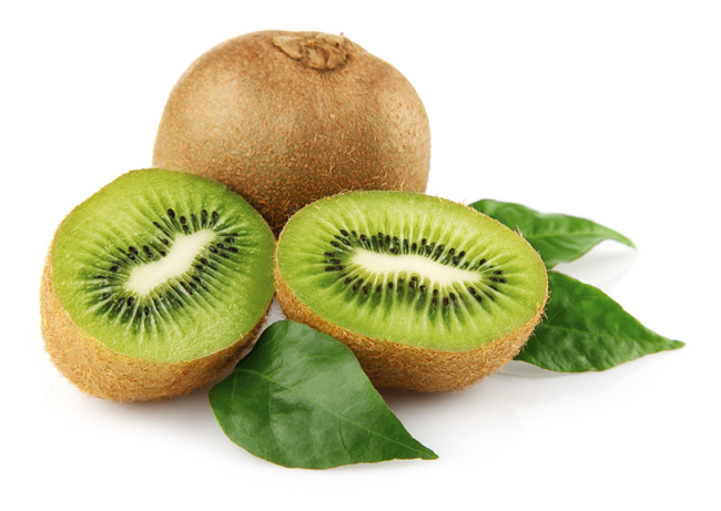 Ecosystem services are benefits obtained by people from ecosystems. That may seem to be a fancy name for what we used to call natural resource use, but there is more recognition of what resources are being used for, and that is for human well-being.
Ecosystem services, on which business and communities depend on, are resources and services provided by nature, such as pest and flood control, pollination, water purification, timber, carbon storage or soil fertility.
As such, consideration of ecosystem services promotes a broader view of all those services that contribute to human well-being, both individually and collectively. Staff from Landcare Research are leading research into this fast growing area where tools and practices for assessing business impacts and dependencies on ecosystems services are still emerging.
Researcher Cerasela Stancu recently completed a rigorous assessment of Zespri’s impact and dependence on ecosystems services utilising the corporate Ecosystem Services Review (ESR) tool developed by the World Resource Institute, one of the most commonly-used measurements.
Zespri is the first business in New Zealand to apply this methodology.
Five priority ecosystem services were identified as important for the continued sustainable production of kiwifruit in the Tauranga catchment.
- Freshwater: kiwifruit growers depend on water available for fruit growing (especially new orchard development) and frost control. Quantity of water is currently satisfactory but water allocation will limit irrigation. Quality overall is declining as a result of nutrient discharge and over-extraction.
- Regulation of water timing and flows: management of the Kaimai Ranges, competing water uses, and increasing water scarcity as a result of climate change are factors that can increase the dependency of kiwifruit production on this ecosystem service. Quantity is currently satisfactory but climate and land-use changes, including deforestation, are likely to lead to instability in water flows, including increased risk of flooding.
- Erosion control: generally, kiwifruit growing and orchards prevent soil loss and sedimentation generation through the vegetation cover they provide. However the incursion of Psa led to significant soil disturbance through orchard removal and re-development had a temporary negative impact on erosion services.
- Maintenance of soil quality: good practices in kiwifruit management systems can maintain and improve soil quality over time, including soil organic carbon. Soil quality is satisfactory and maintained for key indicators such as organic matter content (total carbon, nitrogen) or compaction (bulk density, macroporosity). There are insufficient or inconclusive data for soil microbiology.
- Pest mitigation: kiwifruit orchards are vulnerable to a range of pests and diseases, and integrated pest management practices promote natural controls that would help with pest mitigation. There are insufficient data on the conditions and trends in natural enemy control in kiwifruit industry, especially how climate change is driving changes.
Zespri will now align this work with their sustainability dashboard project which aims to coordinate how the company reports information to kiwifruit industry stakeholders spanning production through to retail.
Contact: Cerasela Stancu
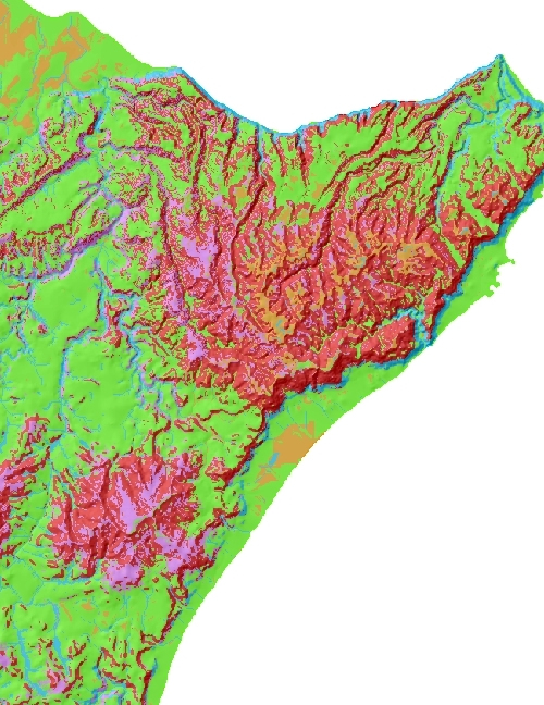
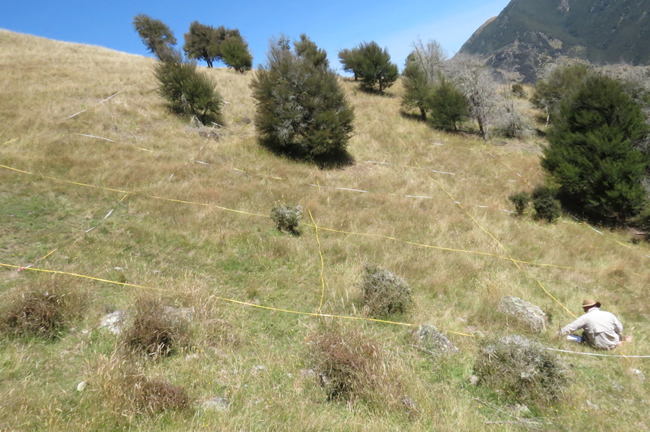
Informing Better Management of the Ross Sea Region
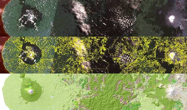
 A comprehensive new Environmental Impact Assessment (EIA) of the Ross Sea region in Antarctica aims to provide a step change in our understanding of the state of the region’s environment and how we manage human activities there.
The innovative new research project, led by Landcare Research, will integrate and analyse three different types of data that exist for the region: environmental; biological; and human movement, activity and impact.
Science Leader Dr Fraser Morgan says the research will fill a critical gap in the environmental management ‘tools’ for Antarctica.
“We aim to provide policy-relevant insights into the environmental pressures facing the region by ‘harmonising’ a wide range of existing data and then using it within five new analyses: climate modelling; biologically available water modelling; digital soil mapping and analysis; analysis and visualisation of environmental constraints for biology; and analysis and modelling of human movement and impact within the region.
“Utilising both the harmonised data and the results from the new analyses, we will develop a new regional scale EIA for the Ross Sea region with Antarctica New Zealand, alongside an easy to use spatial tool to visualise and query the data and analyses. This will enable policy makers to apply the new EIA, and understand and undertake steps to mitigate these pressures.”
A key to the project is the multi-disciplinary nature of the researchers. Landcare Research scientists will be joined by experts at the Universities of Canterbury, Waikato and Auckland, GNS Science, Australian Antarctic Division and Antarctica New Zealand.
“Our research will support New Zealand’s call for the evidence-based management of the region and strengthen New Zealand’s environmental leadership role for the area.”
Contact: Fraser Morgan
Award-winning Modelling
Research that used NZFARM (New Zealand Forest & Agriculture Regional Model) to assess the possible impacts of nutrient and greenhouse gas policies on regional land use and farm profits has been awarded the 2014 New Zealand Economic Policy Prize by the New Zealand Association of Economists.
The work, undertaken by Landcare Research’s Adam Adam Daigneault, Suzie Greenhalgh and Oshadhi Samarasinghe was noted for its rigorous economic modelling techniques and policy relevance, particularly given the recent release of the 2014 NPS for Freshwater.
The now updated NZFARM can be used by central government and regional councils interested in assessing regional impacts of environmental policy on land use. Because it accounts for a number of environmental outputs, it can also be used to assess the impacts of several policies implemented at the same time.
Contacts: Adam Daigneault, Suzie Greenhalgh, Oshadhi Samarasinghe
Website: NZ–FARM: New Zealand Forest and Agriculture Regional Model
‘Ecosystem Services in New Zealand’ – Now Online
The first comprehensive overview of ecosystem services in this country, published earlier in the year, is now available online from the Manaaki Whenua Press website. The content is available as individual chapters.
Environmentally-focused Businesses
Enviro-Mark Solutions has produced two new video case studies on Fletcher Aluminium (Enviro-Mark programme Diamond member) and Sudima Hotels (carboNZero programme member) to highlight their environmental achievements.
Biodiversity
DNA Information Transforming Biodiversity Assessment
 A new Landcare Research-led programme will use DNA analysis to transform biodiversity assessment.
“We aim to make the power of environmental metagenomics – the identification of biodiversity using advanced molecular methods – available to all New Zealanders,” says Science Leader, Jamie Wood.
Individuals (landowners, farmers, foresters, DOC workers, etc.) will be able to sample soils from sites of interest, send the samples to a centralised facility for advanced DNA processing, and receive a complete assessment of the biodiversity present at the site, including plants, birds, insects, pest species, fungi, and microbes.
Traditional approaches to surveying biodiversity are restricted to only a few groups of organisms, such as plants and birds, and not the vast majority of the biodiversity that productivity and sustainable land use relies on, such as microbes and fungi. Current approaches also require significant on-site expertise and lack uniformity across different land use types.
In addition to biodiversity information, the DNA assessment will provide information on key soil functions that underpin biodiversity and productivity, such as nutrient availability and carbon storage.
Jamie says this new faster, more comprehensive and less expensive approach to biodiversity assessment is internationally significant. “Our approach is novel in that it bring together strict field sampling and study design, the combined DNA and soil function analyses, and the framework to analyse all the data and construct metrics around it.
“It will help land managers ensure the long-term sustainability of their terrestrial ecosystems. It will provide government agencies and industry sectors with a better understanding of how different land uses affect biodiversity. It will demonstrate that biodiversity reporting can be achieved in a cost-effective way, and will provide auditable measurement of improvement initiatives.
“For industry, the toolkit will allow robust benchmarking, including green labelling and certification of products and determination of best-practice to maximize biodiversity outcomes. This will enhance the marketability of our primary industry-based products and the New Zealand brand.”
This is the second phase of a programme in which we have already demonstrated the effectiveness of DNA biodiversity assessment. We developed a rapid, cost-effective, and comprehensive DNA biodiversity assessment toolkit and in a pilot study sampled soil DNA from five different land uses (native forest, plantation forest, low-producing farmland, viticulture and irrigated agricultural land) in the Wairau Valley. Molecular information was obtained for 12 taxonomic groups, from bacteria to mammals. We validated the molecular analyses by pairing the results with traditional plot-based plant and bird surveys.
“Interestingly, our initial research showed significant variability in both biodiversity and ecosystem function within individual land uses. This indicates an exciting potential for industries to develop best practice standards so that optimum biodiversity outcomes can be achieved.”
In this second phase we will further develop our DNA assessment toolkit to get a better understanding of biodiversity variability across the country within land use types, and within individual management units (e.g. paddocks).
The Landcare Research-led team, which includes counterparts from University of Auckland and Lincoln University, has received MBIE Smart Ideas Programme funding for this research.
Contact: Jamie Wood
Trying to Cure Kakapo ‘Crusty Bum’
Exudative cloacitis - literally seeping inflammation of the cloaca (the posterior opening that serves as the only opening for the intestinal, reproductive, and urinary tracts of birds) is a pretty nasty thing to get.
But New Zealand’s kākāpō (Strigops habroptilus) certainly does get this debilitating and potentially fatal condition, often referred to as ‘crusty bum disease’, that was first recorded in 2002 on Codfish Island.
Since then thirteen more cases have been recorded, with one possible related death. This has generated considerable concern within the Department of Conservation and, along with the New Zealand Centre for Conservation Medicine (NZCCM) at Auckland Zoo, they have made substantial effort to learn more about the disease. A recent two-day kākāpō and takahe recovery meeting at NZCCM, Auckland Zoo was held in part to update members of the recovery group on progress.
But without a single known cause for the condition (exudative cloacitis can arise from many different pathways and be symptomatic of numerous conditions) and with limited cases arising sporadically over a 12 year period a big question for this work is, where does one begin looking for its cause in kākāpō?
Such a challenge lies at the heart of the newly emerging field of pathogen discovery, and a new and powerful tool, de novo metagenomics, is one approach used by Landcare Research staff Dan Tompkins and Daniel White to search for potential viral causative agents of exudative cloacitis. Since this work relies on generating millions of DNA sequence reads, and subsequent bioinformatics analysis, Dan and Daniel’s work forms part of a collaboration with another CRI (ESR), and relies heavily on the pre-existing collaboration with National e-Science Infrastructure (NeSI) for computing power. And their work has led to an exciting discovery.
Bacteriophages are essentially viruses that infect bacteria, and in one infected female, Rakiura, our staff found a strong presence of bacteriophage TL-2011b, or something closely related. The host E. coli strain for this phage is known to be associated with serious foodborne disease in humans. If confirmed, and repeated in another case, this result would point to a potential route of infection via human activity, likely resulting from the ongoing and intense volunteer program for kākāpō.
The meeting at NZCCM was attended by our staff and gave an opportunity for them to share their findings with the recovery group. Ongoing work was planned and as a direct result of their work, modifications to the management of volunteer programs have been proposed, including hygiene protocol.
Contacts: Dan Tompkins, Daniel White
New Species of Parrot Described
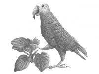 New Zealand officially has a new species of bird but unfortunately, like the Norwegian Blue parrot in the Monty Python sketch: “This parrot is no more. He has ceased to be.” It has been extinct for several hundred years.
Analysis of fossil parrot bones from the Chatham Islands has confirmed that they represent a distinct species, which was once endemic to the island group. The research team have officially named the extinct parrot ‘Nestor chathamensis’ in the latest issue of the Zoological Journal of the Linnean Society.
Scientists first collected large parrot bones from the Chatham Islands in the late 19th Century. The possibility that the bones could represent an undescribed species was first raised in the 1990s, although no one had followed up on this idea since. The new study, which included morphological examination and extracting ancient DNA from one of the bones, has confirmed that the species was distinct, yet most closely related to the New Zealand kaka, says lead author Jamie Wood.
The DNA work used a new method to fish out trace DNA from an ancient bone of the parrot. By comparing the DNA sequence from the Chatham Island bone with those of other parrots, the team estimate the Chatham Islands parrot originated from a kaka that flew to the Chatham Islands around 1.75 million years ago. This was probably not that long after the islands emerged above sea level.
Being large and terrestrial meant the Chatham Islands parrot was probably easy to hunt and, as was the case for similar animals on most islands around the world, it likely became extinct soon after the first human settlers arrived.
Contact: Jamie Wood
Media Release: New species of parrot described from the Chatham Islands
New Tool for Native Plant Selection
Landcare Research has launched NZ Nature Services - a one-stop shop that provides the best native plant selection for your location, environment and purpose.
NZ Nature Services, based on Google type mapping technology, allows the user to locate an area and then find out what native plants would be best suited for a number of different purposes such as habitat restoration, shelter, landscaping, mitigation, wildlife, cultural uses and other ‘ecological services’.
For example a lifestyle block owner could choose the appropriate planting situation within the rural dropdown menu – such as shelterbelt, hedgerow or centre pivot irrigator – then locate their property on the map and a planting list is automatically generated.
Contact: Colin Meurk
Website: NZ Nature Services