Ecosystem Services for multiple outcomes
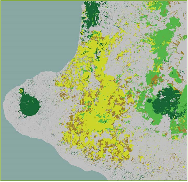
Figure 1. The contribution of Taranaki and inland ecosystems to a national measure of natural habitat provision (a supporting ecosystem service): dark green is high; light green is moderately high; yellow is moderate; brown is low; and grey is near zero.
Communities not only require their environment to provide food and drink but also shelter, livelihoods, lifestyle, and access to goods. These components of human well-being are provided directly and indirectly by both managed and natural ecosystems.
This broader approach to natural resource management, which recognises the full range of services provided to humans, is called the ecosystem services approach.
Landcare Research has been contracted by the Ministry of Science and Innovation to conduct a detailed assessment of ecosystem services for New Zealand. The work has three major objectives:
- identify and assess the full range of ecosystem services
- model future land use/management and associated ecosystem services
- establish an ecosystems service framework to be used by policy and management agencies.
It is planned to make the assessments sufficiently detailed to permit the evaluation of real tradeoffs in resource management.
There have been several key achievements in the programme over the last year:
Optimising ecosystem services: A tool for optimising ecosystem services for spatial configuration of land use has been developed using open-source software. An analysis of the conversion of forestry to dairy in the central North Island was completed, and preliminary results suggest that conversion is not always taking place on the most appropriate soil types.
Soil formation and maintenance: The loss of high-class land to urbanisation over the last 20 years has been determined from satellite imagery as 0.5% (7080 h in 1.3 million hectares). This is not high, but in contrast, the proportion of high-class land occupied by small holdings (“lifestyle blocks”) at 10% is significant and could impact on national food productivity levels.
Provision of fresh water: National models of nitrate and phosphorus leaching based on soil/climate combinations have been developed. The models are used to produce leaching maps at 1:50 000 scale for any area in New Zealand in response to land use and stocking rates. This level of spatial detail exceeds that of presently existing national models. These models will permit better matching of land-use intensification with soil type.
Provision of natural habitat: Recent trends in provision of natural habitat for biodiversity have been quantified using remote sensing. A national measure for provision of natural habitat has been developed (Figure 1) and used to identify contributions from individual ecosystems.
John Dymond