New Zealand – part of GlobalSoilMap.net
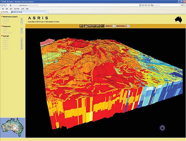
The Global Soil Map will produce a digital 3D map of the world’s soils predicting soil attributes such as carbon and texture. This image shows how the variability of properties with depth can be displayed. Credit: CSIR.
What is GlobalSoilMap.net?
A global consortium has been formed that aims to make a new digital soil map of the world. Data for 11 key soil attributes will be modelled for 6 soil depth increments and mapped at 90-m resolution. Values will be provided to 2-m depth, unless shallower, as continuous depth intervals. The initial attributes are soil depth, percent carbon, pH, bulk density, sand, silt, clay, stones, available water capacity, effective cation exchange, and electrical conductivity. Countries may add other desired attributes to this list. In the first version the data will be modelled from available legacy soil data and uncertainty estimates will show where further investments are necessary to improve accuracy.
The project is very challenging technically and is only now possible given recent advances in digital soil mapping techniques. Alex McBratney and Budiman Minasny of Sydney University have been prominent in the development of the science. Another enabling factor has been the recent availability of spatial prediction layers, for example, the global 90-m digital terrain model derived from the NASA Space Shuttle radar mission.
Equally challenging is the organisation necessary to achieve global coordination. GlobalSoilMap.net will be a major IUSS project. See the web site: http://www.globalsoilmap.net/. Good support has been gained from around the globe as it is well recognised that countries, including New Zealand, have much to gain in terms of capability development, the regrowth of the discipline of pedology (in conjunction with informatics), and support for local soil mapping initiatives.
Why is this needed?
We are all aware of the multiple, looming, global issues of climate change, food security, water quality and quantity, environmental contamination, erosion, etc. Science communities involved in modelling these issues are finding a lack of suitable global soil data. Polygon maps at scales of 1:5 000 000 are available but are too generalised, and it is also difficult to extract attribute information from them. The soil science community needs to lift its sights from local concerns and also contribute effectively to the global modelling efforts.
New Zealand activity
New Zealand is part of the Oceania node of GlobalSoilMap.net, and New Zealanders are involved in the Oceania and Global leadership. Resulting benefits to New Zealand are likely to be the development of new pedological skills in digital soil mapping, and the ability of our national S-map soil mapping programme to operate in conjunction with the global initiative. The intention is to apply GlobalSoilMap.net procedures at finer resolution for local use and deliver a generalised version for the global coverage. S-map is achieving the collation and harmonisation of legacy data as it proceeds so it is setting the stage for GlobalSoilMap.net in New Zealand. For the lowlands where S-map has made greatest progress, GlobalSoilMap.net outputs can be produced by analysis of soil polygons. It will be in the hill and mountain lands that the digital soil mapping techniques of GlobalSoilMap.net will most significantly advance our soil mapping coverage.
There is no external funding for GlobalSoilMap.net in New Zealand. Each node and country has to find their own sources. The Bill and Melinda Gates Foundation has contributed to the global administration, and has adopted the work of the African Node. Another American foundation is contributing to the Latin American Node. The North American Node has already completed draft production of the key attribute layers for the continental US – showing what is possible given good resources and good legacy data. We hope that eventually all the territories of Oceania will be adequately funded and that New Zealand will be part of that. Our role in the Oceania effort will focus on the areas we know best and for which we have significant data sets – the Pacific Islands, Antarctica, and of course the islands of New Zealand.
Allan Hewitt & Pierre Roudier