Making better use of LiDAR in soil and landscape modelling
LiDAR (Light Detection And Ranging) is a remote sensing technique that uses high-frequency laser pulses to gather information about a surface. A LiDAR survey may contain multiple points per square metre over very large areas with vertical accuracies of 0.15 m or even better, enabling the generation of very high resolution Digital Elevation Models (DEMs).
Barriers to using LiDAR
As technology continues to develop and costs decrease, LiDAR is becoming increasingly widely used in New Zealand and internationally. However, a more widespread uptake of LiDAR in New Zealand has been held back by several factors:
- A lack of understanding of what LiDAR is, and how and when it should be used
- A perception that LiDAR is expensive, especially in New Zealand
- A reluctance by organisations to collaborate and share LiDAR data (often due to cost)
- Consequent relatively poor coordination between organisations, and a poor level of awareness of who has, or is using, LiDAR.
As a result, New Zealand’s LiDAR coverage is patchy, mainly project-driven, and raw data are often inaccessible to organisations outside those who commissioned and paid for the original surveys. There is also a lack of consistency as to the level of specification at which LiDAR surveys are acquired, meaning that not all existing LiDAR data are equally suitable for different applications. Additionally, the rapid increase in LiDAR scanner technology, particularly regarding the operating frequency of a modern scanner (as high as 250 kHz, or 250 000 outgoing pulses per second), means that even a small LiDAR survey can now contain many millions of data points – which places great demand on software and computing resources when it comes to processing such large datasets.
So why bother with LiDAR?
Being an active rather than a passive technique, high-quality LiDAR data can be acquired under cloudy skies or low sun angles, unlike aerial photography. LiDAR is also able to “see” through some vegetation canopies, providing a valuable source of elevation data for vegetated areas that would otherwise be obscured on photogrammetrically derived DEMs. LiDAR surveys produce extremely dense and accurate elevation data, making them ideal for mapping and modelling landscape and vegetation attributes at resolutions far higher than previously possible. LiDAR data are also immune to the effects of poor image texture in aerial imagery – which, along with interference by vegetation, can be a major limitation on the quality of photogrammetrically derived “bare earth” DEMs.
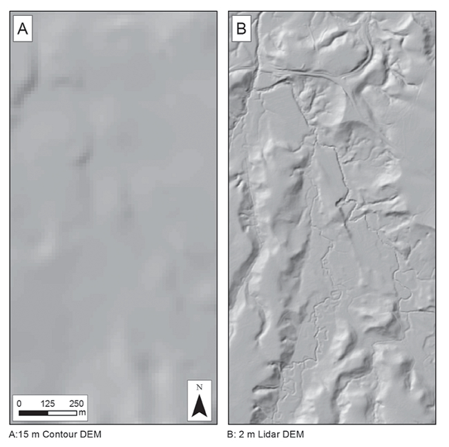
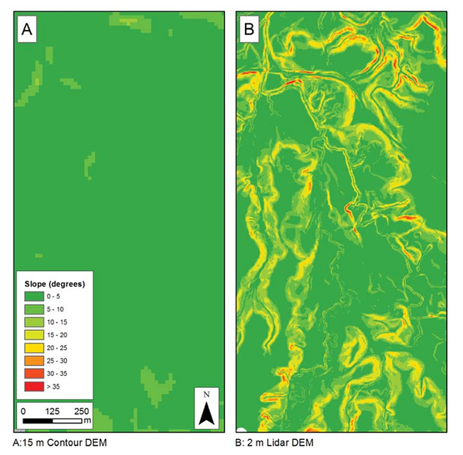
Figure 1 shows an example of how a 2 m resolution LiDAR DEM (for part of the Waitetuna catchment, south of Raglan Harbour) compares visually with Landcare’s existing 15 m national DEM (based on 20 m contour data). Figure 2 contains slope layers calculated from these DEMs. There is no question that the LiDAR DEM contains far more landscape detail than the contour-based DEM, particularly in low-relief areas where 20 m contour spacing is generally wide, with a corresponding lack of detail in contour-based DEMs.
Having national-scale, high-quality LiDAR data would be of enormous benefit to environmental research and management in New Zealand. Such data would support very high-resolution mapping and modelling work, which is becoming more feasible at large scales thanks to ongoing rapid improvements in data processing and storage. The availability of very high-quality environmental data and information would ultimately support more robust regional and national environmental policy decisions.
How could we make better use of LiDAR in New Zealand?
Recognising the opportunity that LiDAR represents for improved landscape mapping and modelling in New Zealand, Landcare Research is undertaking the following in response to the barriers to the uptake of LiDAR uptake identified above:
- We intend to canvass special interest groups such as regional councils, forestry groups and central Government (the latter via the NZ Geospatial Office) to determine whether there is national support for a NZ-wide LiDAR coverage
- We are developing a set of open-source software tools (based mainly on GRASS, a leading open-source GIS software package), that will be capable of utilising Landcare’s high-performance computing capabilities. This will enable us, quickly and efficiently, to generate high-resolution DEMs and DEM derivatives such as slope, aspect, and hydrological indices directly from very large LiDAR datasets. This facility could also be used, along with our own expertise, to process LiDAR data for third parties
- As part of Landcare’s proposed National Land Resource Centre, we could potentially act as a custodian for a national-scale LiDAR dataset, using our newly developed capability to process and “serve up” LiDAR-based DEMs and DEM products on demand, as well as working to improve the consistency and quality of metadata for LiDAR data nationwide.
Harley Betts & Pierre Roudier
Figure 1. Shaded relief views of 15 m contour-based DEM (Panel A) and the equivalent 2 m LiDAR DEM (Panel B). Note the far higher level of landscape detail on the LiDAR DEM. (Raw LiDAR data courtesy of Environment Waikato.

Figure 2. Slope layers generated from 15 m contour-based DEM (Panel A) and the equivalent 2 m LiDAR DEM (Panel B). The LiDAR DEM would clearly be much more useful for high-resolution erosion applications requiring slope information, such as erosion and soil-landscape modelling. (Raw LiDAR data courtesy of Environment Waikato.