Tracking the depth to water table in the Manawatu Sand Country
We are using a wireless network of sensors installed in the ground to monitor soil moisture and depth to water table at our research site in the Manawatu Sand Country. Information is transmitted every 15 minutes from the sensors to a base station and from here to a website.
We are also using soil survey gear that uses very accurate GPS (centimetre accuracy) in conjunction with an electromagnetic (EM) sensor to map soil electrical conductivity at very high resolution. The high resolution soil map is used with the water table data to model depth to water table accurately at any one position. This information is used for precision irrigation scheduling.
The Manawatu Sand Country, the largest area of coastal dunes in New Zealand, is a complex of sand dunes and plains, peat swamps and lakes. Early development of these soils was hampered by wind erosion, and variably high water tables. However, the introduction of forestry onto sand dunes, and minimum cultivation and controlled drainage of sand plains are enabling successful agricultural development of this region. Depth to water table does vary in the undulating sand plains, with freely draining hydrophobic areas frequently occurring next to low-lying zones with high water table that remain relatively wet into the late spring, inhibiting plant establishment.
Excessively high water tables can be controlled to some extent by insertion of drainage channels to maintain the subterranean freshwater resource at an optimum depth of about one metre below the bottom of the root zone. However, the undulating and variable nature of the terrain still results in significant depth differences to the water table in any one irrigated field. Where precision irrigation scheduling is employed, these site-specific differences need to be addressed. We have therefore developed a method to map and monitor varying depths to the water table so that the effect of the water table on soil water status and irrigation timing can be managed precisely.
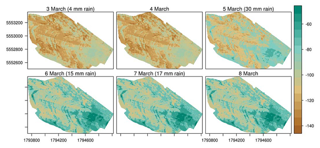
The electromagnetic sensor used in the soil survey measures soil electrical conductivity, which is closely related to soil moisture in these uniformly textured sand soils. Soil moisture, in turn, reflects the depth of the water table at this site. The soil electrical conductivity map is therefore used both to delineate soil moisture zones and to determine where to place sensors to monitor water table depth. We have used the EM survey and rainfall data to develop a mathematical model to accurately predict depth to water table (Figure 1).
The ability of our wireless sensor network to monitor water table and soil moisture simultaneously provides direct information about the amount of plant-available water. Our research, in collaboration with Massey University, continues to develop this method for real-time variable rate irrigation scheduling.
Carolyn Hedley, Pierre Roudier & Jagath Ekanayake