New editions of the NZ Land Cover Database
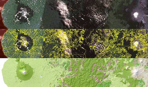
LCDB – from satellite imagery (top) to a useful map (bottom).
How and where is land cover in New Zealand changing through time? What are the major characteristics of this change? These two key questions will be answered by new editions of the New Zealand Land Cover Database (LCDB).
LCDB is a digital map of the surface of New Zealand created using satellite imagery. It contains detailed information on categories of land cover and boundaries, and is a record of land-cover changes over time.
Two completed editions (LCDB1 and LCDB2), which show the state of New Zealand’s land cover in 1996–1997 and 2000–2001 respectively, have become critical to central, regional and local government, industry and research institutions. The information is used for land, water and biodiversity management, pest control and monitoring, wildfire threat and risk analysis, and environmental monitoring and reporting.
The creation of new land-cover databases and related research has been identified as an important priority by the Ministry for the Environment (MfE), Department of Conservation (DOC), and regional councils. Landcare Research has been commissioned to deliver two further editions of LCDB and a parallel research programme that will develop improved ways of generating land-cover information.
LCDB3 will be derived from the 2008 satellite imagery used for the MfE Land Use & Carbon Analysis System (LUCAS) and delivered in July 2012, while LCDB4 will use 2012 LUCAS imagery and will be delivered in July 2014.
“This project will answer key environmental research questions about how land cover is changing,” says Project Leader, Peter Newsome. “This research has spin-off benefits for other applications that require spatial analysis and classification of imagery – ranging from the monitoring of sustainable land use, habitat analysis, agricultural applications, economic modelling, to disaster response planning.
“Our goal is that by 2015 end-users will have access to a well-established series of LCDB editions that provide the authoritative record of land cover and land-cover change in New Zealand. We expect these datasets will be widely used to support decisions on land use, along with monitoring and reporting requirements.
“Landcare Research will then have an effective methodology, and the experience and user support, to take the series into the future, with a land-cover classification that utilises the most appropriate satellite imagery available.”
The project is collaborative, with contributions from the MfE, DOC, MAF, and regional councils.
The development of LCDB3 and LCDB4 is largely being funded by Ministry of Science and Innovation, with financial support also from MfE, DOC, MAF and regional councils.
David Pairman