Land Environments of New Zealand - improved methods and tools for ecosystem conservation and management
Goal 3 of the New Zealand Biodiversity Strategy aims to halt the decline of indigenous biodiversity by (a) maintaining and restoring a full range of habitats and ecosystems and (b) maintaining and restoring viable populations of all indigenous species and subspecies across their natural range and maintaining their genetic diversity. Meeting that goal requires knowledge about the extent and status of species, habitats and ecosystems across a range of scales, including how well the full range of ecosystems is represented within the national conservation network.
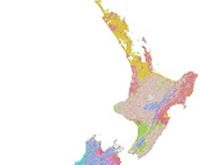
LENZ 20 Environments
Goal 3 of the New Zealand Biodiversity Strategy1 aims to halt the decline of indigenous biodiversity by (a) maintaining and restoring a full range of habitats and ecosystems and (b) maintaining and restoring viable populations of all indigenous species and subspecies across their natural range and maintaining their genetic diversity. Meeting that goal requires knowledge about the extent and status of species, habitats and ecosystems across a range of scales, including how well the full range of ecosystems is represented within the national conservation network.
Landcare Research developed the Land Environments of New Zealand (LENZ) classification as a quantitative, multi-scale system to underpin ecosystem conservation and management. LENZ classifies New Zealand's terrestrial land environments based on their environmental similarity. Land environments serve as a simpler surrogate for more complex ecosystems for which we have incomplete information and provide a framework to help assess progress toward Goal 3.
The LENZ system consists of 15 underlying data layers on which the classification is based and 4 classification layers dividing New Zealand into 20, 100, 200, and 500 land environments. When coupled with other land information systems, especially the Land Cover Database (LCDB) and Protected Areas Network (PAN-NZ) database to generate the Threatened Environments classification, LENZ helps quantify: (a) condition of land environments, (b) ‘representativeness' within the protected areas network, and (c) susceptibility to future loss, primarily through land clearance. The LENZ underlying data layers also have a range of uses related to assessment of land suitability and economic potential.
Since its introduction in 2003, LENZ has contributed to a wide range of biodiversity conservation policy, planning and management across New Zealand including:
- Underpinning National Priority 1 Guidelines for protection of biodiversity on private land2
- DOC strategic planning3
- MfE reporting on national environmental indicators for biodiversity4
- Second-generation regional policy statement for Horizon's One Plan5
- Wellington Region State of Environment (SoE) reporting6
- Analysis of representativeness for West Coast and Nelson City7
- Supporting DOC's review of the National Coastal Policy Statement8
- Helping delineate the historical and current extent of wetlands in the Waters Of National important (WONI) project9
- Assessing the biodiversity outcomes of the High Country Tenure Review process10
An unexpected offshoot of LENZ has been the use of the underlying data layers to help evaluate the suitability of land for different uses11.
DOC's use of LENZ enables much more effective conservation outcomes to be achieved from ~$75m spent annually on protecting biodiversity. DOC spends about $187.5m annually on conservation, with about 40% of the expenditure focused primarily on biodiversity retention goals (T. Stephens, pers. comm.). Cost-effectiveness analysis has shown that the most cost-effective mix of projects produces cost:benefit gains of 1000-fold. DOC uses the LENZ classification to assess environmental representation - a key component of ecological integrity - in identifying the best mix of projects to maximise biodiversity outcomes.
LENZ is one of five ecological classifications used by MfE for national state of the environment reporting4, which forms the basis for international assessment (e.g. by the OECD) of New Zealand's environmental performance. Recognising that better prioritisation and national direction would help focus restoration and protection efforts, in 2003 MfE encouraged improved regional management of biodiversity by providing the LENZ data set (classification layers and underlying data layers) on CD to all regional and district councils in New Zealand to use in their biodiversity and conservation planning. In July 2009 MfE made LENZ more accessible and easier to use by making it available online12 with a Creative Commons attribution licence that allows the public to freely use, share and distribute the data.
Landcare Research's development of LENZ occurred in three phases. Foundational work took place as part of the FRST-funded Biodiversity Indicators Programme (1996-2000; $250,000 was allocated to LENZ) and regional trials funded by MfE. MfE also provided funding for the final classification (dataset, books, data CDs) (2000-2002, $900,000 in total). Uptake and maintenance from 2003 to the present was initially funded via sales of data CDs (~$10,000 to $150,000 per annum in revenue), aligned Capability Funding from MoRST, and a Terrestrial Freshwater Biodiversity Information Systems (TFBIS) project to co-fund regional workshops. Even if only the benefits quantified by the small sample of LENZ users interviewed for this case study are accounted for, the rate of return on the science investment easily exceeds 9% per annum.
Notes
- Department of Conservation, 2000. The New Zealand Biodiversity Strategy. http://www.biodiversity.govt.nz/
- Ministry for the Environment ‘Biodiversity on Private Land Guidance'
http://www.mfe.govt.nz/issues/biodiversity/initiatives/private-land/work-programme.html#national - Department of Conservation Statement of Intent 2009-2012.
http://www.doc.govt.nz/upload/documents/about-doc/role/policies-and-plans/statement-of-intent/statement-of-intent-(2009-2012).pdf . LENZ was used to assess environmental representation for the Department of Conservation´s Vital Sites Project. See Overton & Price, 2008. - Ministry for the Environment 2007. Environment New Zealand 2007.
http://www.mfe.govt.nz/publications/ser/enz07-dec07/ - Horizons One Plan. LENZ was used to identify and quantitatively classify habitat types to support policy frameworks developing around biodiversity (providing a crucial component of the policy framework) and underpin both the regulatory and non-regulatory methods for the implementation of the One Plan. In the work, LENZ was combined with other types of information, such as natural vegetation types, wetlands extent, and current land cover to assess areas of high priority for protection or restoration.
- Wellington Regional Council uses LENZ to report on the state of ecosystems within the region (http://www.gw.govt.nz/story13109.cfm)
- Landcare Research undertook Envirolink-funded analyses of the status of land environments for West Coast Regional Council (Price & Briggs 2006) and Nelson City (http://biodiversityasia.net/strategy/nelson%20nz.pdf)
- LENZ was used to assess condition and trends in terrestrial coastal environments (Rutledge et al. 2007)
- Ausseil A-G, Gerbeaux P, Chadderton WL, Stephens T, Brown D, Leathwick J 2008. Wetland ecosystems of national importance for biodiversity: Criteria, methods and candidate list of nationally important inland wetlands. Landcare Research Contract report LC0708/158. 174 p.
- Landcare Research assessed the biodiversity outcomes of the High Country Tenure Review process for LINZ.
- LENZ underlying data layers have contributed to land use suitability evaluations for Taupo, analyses for Taupo and the Waikato region and for creating land use suitability layers for the Waikato Region Integrated Spatial Decision Support System (www.creatingfutures.org.nz).
- http://koordinates.com/maps/environment/
Additional References
Ausseil A-G, Dymond J, Shepherd J 2007. Rapid mapping and prioritization of wetland sites in the Manawatu-Wanganui Region, New Zealand. Environmental Management 39: 316-325.
Leathwick J, Wilson G, Rutledge D, Wardle P, Morgan F, Johnston K, McLeod M, Kirkpatrick R. 2003a. Land environments of New Zealand - Nga Taiao o Aotearoa. Auckland, David Bateman. 184 p.
Leathwick J, Morgan F, Wilson G, Rutledge D, McLeod M, Johnston K 2003b. Land environments of New Zealand: A technical guide. Auckland, David Bateman. 237 p.
Overton JMcC, Price R 2008. Identifying vital sites to avert biodiversity loss in New Zealand. Landcare Research Contract Report LC0708/095 to the Department of Conservation.
Price R, Briggs C 2008. Threatened environments classification for the West Coast Region, New Zealand.
Rutledge D, Price R, Ausseil AG, Heke H 2004. National analysis of biodiversity protection and status: methods and summary results. Landcare Research Contract Report LC0405/042 prepared for the New Zealand Ministry for the Environment. 30 p.
Rutledge D, Briggs C, Price R, Ausseil AG, Belliss S, Morgan F 2005. LENZ regional workshops final report. Landcare Research Contract Report LC0405/126 prepared for the New Zealand Terrestrial and Freshwater Biodiversity Information System Programme (TFBIS). 22 p.
Rutledge D, Briggs C, Price R 2007. Condition and trends of terrestrial coastal environments. Landcare Research Contract Report LC0506/148 prepared for DOC. 67 p.
Walker S, Price R, Rutledge D, Stephens RTT, Lee WG 2006. Recent loss of indigenous cover in New Zealand. New Zealand Journal of Ecology 30: 169-177.
Walker S, Price R, Rutledge D 2008. New Zealand's remaining indigenous cover: recent changes and biodiversity protection needs. Science for Conservation 284. 82 p.