Modelling hill country erosion
Annual costs associated with hill country erosion are estimated by MAF to be $100-150m per annum. Costs result from loss of soil and nutrients, lost animal-production, and damage to pasture, waterways and infrastructure. The Ministry spends $2.5m per annum to build regional council capacity to address erosion.
Erosion
Annual costs associated with hill country erosion are estimated by MAF to be $100-150m per annum1. Costs result from loss of soil and nutrients, lost animal-production, and damage to pasture, waterways and infrastructure. The Ministry spends $2.5m per annum to build regional council capacity to address erosion2.
In collaboration with Horizons Regional Council, Landcare Research modelled hill country erosion in the Manawatu-Wanganui Region. The model linked erosion and sediment yields to land use and management and illustrated the potential to almost halve soil loss by targeting regional sustainable land management initiatives to reduce erosion and sedimentation. On a regional basis this translates to cost savings of $11m3 to $22 m4 per annum. As erosion is a similarly significant problem for other regions, annual savings of $50-75m nationally are possible5 through the effective adoption of land management initiatives to reduce hill country erosion. Realisation of these benefits would yield a 250-fold return on the modest (~$300,000 over 5 years) investment in catchment erosion modelling to date.
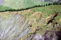
The Manawatu-Wanganui Region is one of six regions1 particularly prone to hill country erosion. Over 12% of the region - 270 000 ha of land - is at risk to landsliding because it is steep and has no forest cover. Consequent economic losses from decreased production are considerable - hill country sheep and beef cattle farming in the region directly contribute $125m to the Gross Regional Product (GRP), and a further $125m (approx.) through its supply chain (i.e. services to agriculture)6. Sustainable management of hill country is therefore a major priority for action in Horizons Regional Council's One Plan. Based on the value of the benefits identified through the Landcare Research erosion modelling study, the council will spend $40m on its Sustainable Land Use Initiative (SLUI) to implement whole-farm plans to improve sustainable land use and soil conservation in the region.
As part of SLUI, Landcare Research identified land at risk to landsliding in the region. A simplified version of the SedNet model was used to link erosion and sedimentation in the Manawatu River with land use, management and soil conservation activities. SedNet constructs sediment and nutrient budgets for regional-scale river networks (from 3000 to 1 000 000 km2). A budget consists of the major sources, stores and fluxes of material. The model was used to examine the effect of targeting implementation of soil conservation measures (as defined in whole-farm plans produced under SLUI) on ‘downstream' effects of erosion/sedimentation in the Manawatu River.
At present, an average of 3.8 million tonnes of hill country soil is lost to the sea each year as sediment transported by the Manawatu River. The modelling study indicated that targeting implementation of whole-farm plans (including soil conservation) first on the 10% of farms (500) in the most highly erodible areas of the catchment would almost halve sediment generation - reducing soil loss by 1.8 million tonnes, 25% of which is topsoil. In contrast, a non-targeted first-in first-served approach to farm plan implementation had little impact (8% reduction) on sediment. On the basis of avoidance of capital loss, and assuming a bulk-purchase retail value of topsoil of $30 per tonne, the value of avoided erosion in the Manawatu catchment alone is $11m3. An additional ~$0.9m per annum is saved in avoided costs of flood protection works. Horizons Regional Council is upgrading its flood control works because of sedimentation of berms, and currently plans to spend about $36m on work with a 20-year lifespan - i.e. a cost of $1.8m per annum. Reduction in sedimentation by 50% would therefore be worth half that amount, valued on the basis of avoidance of cost.
If, as estimated by MAF1, planting for conservation reduces post-storm erosion from 10% to 1% of a catchment, targeting conservation first at the most highly erodible areas has the potential to reduce losses to the region's GRP by $22.5m4. Landcare Research's work over 5 years (2004-2008) has involved three FTEs and has been funded ($300,000) by FRST and MoRST (through capability funding) and $10,000 by Horizons Regional Council. The research has provided for Horizons a mechanism to mitigate future risks that are likely to increase (7).
References and assumptions
- The Manawatu-Wanganui region contributes a significant portion of the national erosion problem, with Gisborne, Greater Wellington, Hawke's Bay, Taranaki, and Northland regions.
www.maf.govt.nz/mafnet/rural-nz/slm-hill-country-erosion-programme/page.htm - MAF's Sustainable Land Management (SLM) Hill Country Erosion Programme.
- Estimate based on ‘retail' value of topsoil component of 1.5 million tonnes of soil lost per annum - the difference between soil losses with targeted and non-targeted farm plans; assuming 25% of the soil lost is topsoil.
- Estimate based on MAF's estimated reduction in post-storm erosion from a catchment (from 10% to 1% - see (1)) - protecting 9% of hill country from soil loss by conservation plantings, and of the $250m direct and indirect contribution of hill country to GRP (from Montes de Oca Munguía et al. 2009 - see (6)).
- Estimation assumes that national costs are directly associated with soil loss and/or sediment production, and that all six regions with high erosion risk have similar patterns and types of erosion to the Manawatu-Wanganui study region. The model used assumes riverbank erosion is equivalent to floodplain deposition, so the source of sediment in the Manawatu River is primarily hillslope erosion.
- 2004 figures in: Montes de Oca Munguía O, Andrew R, Forgie V, Lennox J 2009. Environmental input-output analysis of the Horizons Region Pastoral Sector. Landcare Research Contract Report LC0809/129, Palmerston North.
- Climate change may result in the region becoming up to 20% wetter with more varied rainfall patterns, and the frequency of flooding is predicted to increase up to four-fold by 2070.
www.mfe.govt.nz/issues/climate/about/climate-change-affect-regions/manawatu-whanganui.html
Additional References
Dymond JR, Betts HD (in prep.) An erosion model for evaluation of regional land-use scenarios in New Zealand. Environmental Modelling & Software.
Dymond JR, Shepherd JD 2006. Highly erodible land in the Manawatu-Wanganui Region. Landcare Research Contract Report LC0607/027 to MAF Policy.
Dymond JR, Ausseil A-G, Shepherd JD, Buettner L 2006. Validation of a region-wide model of landslide susceptibility in the Manawatu-Wanganui Region of New Zealand. Geomorphology 74: 70-79.
Krausse M., Eastwood C., Alexander R.R. 2001. Muddied waters: estimating the national economic cost of soil erosion and sedimentation in New Zealand. Palmerston North, Manaaki Whenua - Landcare Research.
Schierlitz C, Dymond JR, Shepherd JD 2006. Erosion/sedimentation in the Manawatu catchment associated with scenarios of whole farm plans. Landcare Research Contract Report LC0607/028 to MAF Policy.