Indigenous forest remnants
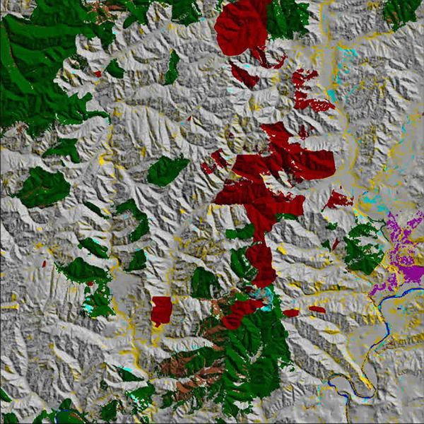
Extract from EcoSat basic land cover of Manawatu/Wanganui region. Dark green is indigenous forest. Dark red is pine forest. Brown is narrow-leaved scrub. Yellow is unspecified woody vegetation. Grey is pasture. Cyan is bare ground. Purple is urban bare ground (Taumaranui). Blue is water
Indigenous forest remnants play an important role in the biodiversity of rural landscapes. Indeed, some of these remnants are the only remaining survivors of certain forest types. They sometimes contain rare species of plants, and for many indigenous birds in a rural landscape they provide the only habitat. The EcoSat project can now map indigenous forest remnants down to less than one quarter of a hectare, which is useful for compiling a regional inventory of remnants and the networks they form. Landcare is now collaborating with Horizons Regional Council to develop methods to use this information to prioritise remnants for conservation in the Manawatu/Wanganui region.
Resources available for biodiversity conservation are small compared with the work to be done. So resources need to be targeted to those remnants that make the greatest contribution to biodiversity. But where does one start, given that the full extent of biodiversity in the landscape is extremely difficult to measure? Rather than relying on schemes to estimate biodiversity value, which are necessarily subject to arbitrary rules, we intend to develop more robust methods using a goal-based approach to conservation. Forest remnants may be ranked according to their contribution to habitat goals, and then resources targeted to those remnants contributing most to the goals.