Possum Habitat mapping
The Animal Health Board (AHB) requires the effectiveness of possum control operations be monitored to ensure these operations are preventing the spread of TB from possums to cattle. This monitoring procedure involves placing possum traps in lines through potential possum habitat. This habitat can in practice be any type of woody vegetation, such as forest, scrub or blackberry. It is important to know the distribution of these wooded areas, as scattered scrub and shelterbelts on farmland can support a high density of possums. However, these areas are small and can change quite quickly. Manual mapping methods such as those employed in the current national vegetation map, the Land Cover Database (LCDB) are not easily able to map woody vegetation to the required level of detail (much less than the LCDB minimal mapping unit of 1 ha).
Our techniques allow the mapping of woody vegetation automatically from Landsat ETM+ satellite imagery. This imagery is ideal for 1:50 000 regional mapping as it has a large footprint (180 km x 180 km) and can be processed to 15-m pixel detail (about 50 pixels per hectare). The classification process involves first identifying non-vegetation areas (such as water and bare ground), and then dividing vegetated areas into either woody or herbaceous classes.
 |
 |
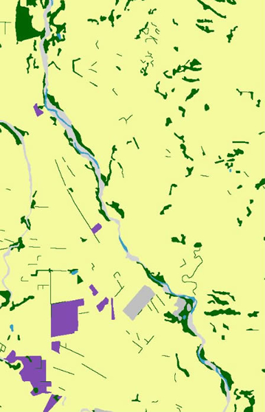
| LCDB2 woody vegetation (dark green) | EcoSat woody vegetation (dark green) |
This figure compares the spatial detail of the LCDB2 with the EcoSat woody layer. They both map large and medium patches of woody vegetation accurately, but EcoSat maps the the smaller patches with much greater detail.
The high accuracy of this woody classification is due to the Landsat sensor having bands in both the visible and infrared parts of the spectrum (6 in total). This provides more spectral information than aerial photography and can be calibrated to reflectance. Once woody vegetation is identified, the 15-m pixel map can then be used in a GIS to give an accurate area of potential possum habitat for a control operation. This area then defines the number of trap lines required for monitoring. The computer can randomly place lines within the control area, greatly speeding up the process of monitor design. As imagery can be routinely acquired, the map of woody vegetation can be regularly updated to account for changes in scrub or exotic forestry.